_from_Mill_Mountain_Star_at_Dusk.jpg)
Roanoke, Virginia
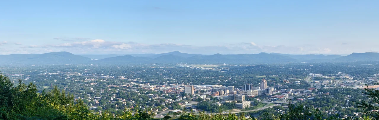
On a December night in 1949, the Roanoke Merchants Association switched on an 88.5-foot illuminated star atop Mill Mountain. It was meant to advertise the Christmas shopping season. People kept the star burning past Christmas, past New Year, and never turned it off. Seventy-five years later it still glows above the city - and the city has been called the Star City of the South ever since. From a long way off, the star is the first thing you see at night. The Roanoke Valley narrows around it, the Blue Ridge cradles it from three sides, and the city below it is the largest urban place in Virginia west of Richmond.
Big Lick, Bigger Bet
Roanoke was once a small place called Big Lick - named for the salt deposits that had drawn game to the valley for centuries. Before that, the Roanoke Valley was home to the Tutelo, a Siouan-speaking people who were gradually pushed out by Scotch-Irish and German farmers in the 17th and 18th centuries. The town's transformation began in 1882, when the Norfolk and Western Railway chose Big Lick as the junction of the Shenandoah Valley Railroad and the N&W. Residents voted to rename the town Kimball, for railroad executive Frederick J. Kimball. Kimball declined the honor. On the Roanoke River in Roanoke County, he said - name it Roanoke. They did, on February 3, 1882. By the end of 1883, the population had passed 5,000 and the new Hotel Roanoke had opened its doors. On January 31, 1884, Roanoke became a city.
The Magic and the Magic City's Failures
Between 1880 and 1890, Roanoke's population grew from under 700 to over 16,000 - twenty-two times its starting size. The Magic City, the nickname stuck. But the infrastructure was nonexistent. No sewers. Marshy ground. Repeated outbreaks of diphtheria and cholera. Bond initiatives to fix the problems exposed deep racial fractures: the African American community made up about 30 percent of the population in 1891, and they opposed bonds that would pay only for improvements to white neighborhoods. Roanoke was among the first Southern cities to adopt Jim Crow laws. In September 1893, a mob of hundreds surrounded the city jail demanding the African American prisoner Thomas Smith. A shootout with the militia left eight dead and thirty-one wounded - among them Mayor Henry Trout, who had vowed to protect Smith. The mob got him anyway. Smith was lynched and his body mutilated. National condemnation followed; Mayor Trout, who had fled for his life, returned a week later to be praised for his courage.
Mountain Star and Marsh Town Gone
Through the early 20th century, the city kept growing - from 0.5 square miles at incorporation to over 42 square miles by 1980. Mill Mountain, the 1,700-foot summit that stands detached from the surrounding ridges, became the city's recreational heart. An incline railway ran up it from 1910. Mountain Park, with a casino and roller coaster, opened at its base in 1903. Roanoke Memorial Hospital, completed in 1900, is now the flagship of Carilion Clinic. The American Viscose plant, built in 1917, became reportedly the largest rayon mill in the world. Then came the urban renewal era. In a sweeping mid-century clearance, the city demolished over 1,000 buildings, often through controlled burning, to build the Civic Center and the I-581 interstate spur into downtown. Whole African American neighborhoods - Gainsboro especially - lost most of their fabric in the process.
After the Railroad
In 1982, the Norfolk and Western merged with the Southern Railway to form Norfolk Southern, which immediately moved its headquarters from Roanoke to Norfolk. The corporate departure that built the city took its keys back. The railroad shops closed in stages, the last shuttering in 2020. Manufacturing followed. Roanoke had to remake itself. It did so on two pillars: a robust healthcare industry centered on Carilion, and the deliberate development of its outdoor amenities. The valley now has 26 miles of greenways for walking and cycling. The city is the largest along the Appalachian Trail, which runs just north, and along the Blue Ridge Parkway, which runs just south. Carvins Cove, the second-largest municipal park in America at 12,700 acres, sits in the hills outside town. In 2020, the population passed 100,000 for the first time since 1980. The star still burns.
From the Air
Roanoke sits at 37.27 N, 79.94 W along the Roanoke River in the Blue Ridge foothills, 50 miles north of the Virginia-North Carolina line. Cruise at 5,500 to 8,500 feet MSL for valley orientation. The illuminated Roanoke Star atop Mill Mountain (1,700 feet) is visible day and night and serves as a key visual landmark. Hotel Roanoke (Tudor Revival) stands prominently in downtown. The Appalachian Trail runs just north of the city, the Blue Ridge Parkway just south. Nearest airport is Roanoke-Blacksburg Regional (KROA) at field elevation 1,176 feet, served by I-581. Watch for ridge-induced turbulence in westerly winds.
Nearby Stories
- Battle of Galudoghson 1.8 km away
- Franklin County, Virginia 14 km away
- Poplar Forest 17 km away
- Pulaski County, Virginia 18 km away
- Alleghany County, Virginia 18 km away
- Draper's Meadow Massacre 19 km away
- Hargrave Military Academy 29 km away
- 2020 Williamsburg Massacre 42 km away