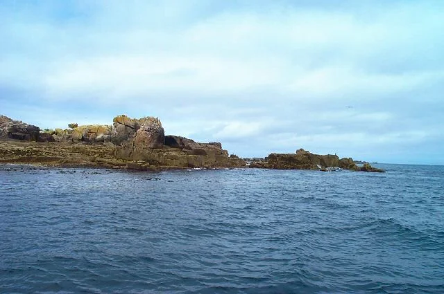

Rosevear
Rosevear is 0.63 hectares of flat-topped granite in the Western Rocks of Scilly, and you are not allowed to land on it. The Duchy of Cornwall owns it, the Isles of Scilly Wildlife Trust manages it, and storm petrels nest there in numbers that make the rest of the island a closed door for human feet. But for almost three hundred years, Rosevear was one of the strangest pieces of inhabited land in Britain - a wave-pummelled rock, a kilometre and a half from the nearest other island, that humans kept moving back onto. In 1709 it was a salvage camp for the wreck of HMS Association. In 1784 it received the body of an English opera singer and her infant son, both drowned on a packet ship at the edge of the rocks. In the 1840s and 1850s it housed the masons and engineers building Bishop Rock lighthouse, and they swore they heard music in the night. The lighthouse-builders left in 1858. The opera singer's ghost, the local story says, never did.
The Rock Itself
The Western Rocks of Scilly are a 3-kilometre chain that runs from Round Rock of Crebawethan in the north down to Pednathise Head in the south, the southernmost land in the United Kingdom. Rosevear sits about midway down the chain, the largest of the group, with a relatively flat top rising to about five metres above the high-water mark. The Cornish name means 'great promontory', which captures both its outline - longer and flatter than the surrounding stacks - and its size relative to the smaller rocks around it. It has no soil to speak of, no fresh water, no shelter beyond what humans built and what storms inevitably took back. The seabed around it is littered with metal: a ship's funnel from the Cité de Verdun, wrecked there in 1925, lies amongst the rocks. There are more wrecks here than there are stones above water.
Ann Cargill
On 24 February 1784, the East India Company packet ship Nancy ran onto the rocks near Rosevear in heavy weather. Most of the people aboard drowned. Among the dead was Ann Cargill, a celebrated English opera singer and actress in her mid-twenties, returning home from a performing engagement in India. Her body washed onto Rosevear still holding her 18-month-old son. The captain, a man named Haldane, was found with them. All three were initially buried on Rosevear itself - there being nowhere else nearby to put them - and only later moved to consecrated ground at Old Town Church on St Mary's. Cargill had been one of the most famous singers of her generation, a soprano who had performed at Covent Garden and the King's Theatre, and her death drew widespread mourning. The Scillonian story, as it grew over the next two centuries, became something more local and more haunted: Ann Cargill walks Rosevear at night, looking for her son. The men who built the Bishop Rock lighthouse, sixty years later, said they heard music in the wind. They believed it was hers.
Salvage and the Lighthouse Camp
Two decades after the Association disaster of 1707, the Royal Navy was still trying to recover what it could from the wrecks scattered through the Western Rocks. In 1709 and 1710, the Herbert salvage expedition used Rosevear as a base camp, working the wreck of the Association and the three other warships lost the same night. They were diving by skin-dive standards, with weights and held breath, in tide-driven water that has killed strong swimmers in our own century. What they recovered is now in museums and private collections; what they left, twentieth-century diving teams eventually found. Then, in the 1840s and 1850s, the rock filled with people again. The masons and engineers building James Walker's first Bishop Rock lighthouse - the iron-legged tower that the Atlantic destroyed before it could be completed - lived on Rosevear in barracks while they worked. The same workmen returned for Walker's second, stone-built tower in the 1850s. The remains of their structures were designated a Scheduled Monument in 1997. The men who lived in them told their families they heard mysterious music. They were on Rosevear, three kilometres from the nearest other human, in storm season.
The Birds That Stayed
Today Rosevear is one of the most important storm petrel colonies in England. The Seabird 2000 survey counted 57 occupied nest sites; by the 2006 repeat survey, that number had risen to 129, making Rosevear the third-largest European storm petrel colony in the country. The island also holds nationally significant numbers of European shag, which roost in cliff cracks across the Western Rocks group. Atlantic puffins, razorbills and great black-backed gulls all use it. In October 1990, the naturalist Rosemary Parslow happened to be there during a heavy fall of migrant land birds, and recorded dozens of European robins and goldcrests, and several rare yellow-browed warblers, all feeding through the wind-pruned vegetation. The Site of Special Scientific Interest designation came in 1971, and it is unambiguous: no landing. The Duchy of Cornwall owns the rock, the Wildlife Trust patrols it, and Rosevear, after centuries of being lived on and dug up and built upon and fought over, is now the simplest thing in the chain - a place that humans look at from outside and let alone.
From the Air
Rosevear lies at approximately 49.87 N, 6.40 W, in the Western Rocks of the Isles of Scilly. The nearest airport is St Mary's (EGHE), about 9 km east-northeast, with Land's End (EGHC) some 52 km east on the Cornish mainland. Bishop Rock lighthouse, 4 km southwest, is the primary visual landmark. The island is a flat-topped granite mass distinct from the surrounding smaller stacks of the Western Rocks chain. Recommended viewing altitude is 1000-2000 ft AGL. Do not overfly low - the island is a designated SSSI and a critical storm petrel colony. Expect strong Atlantic winds and reduced visibility off the open ocean.
Nearby Stories
- Wolf Rock Lighthouse 17 km away
- The Brisons 18 km away
- SS Irma (1905) 22 km away
- HMS Brisk (1851) 31 km away
- Cape Cornwall Mine 57 km away
- SM U-27 73 km away
- Wolfpack Prien 162 km away
- Tower of Hercules 696 km away