.jpg)
Sambisari
In July 1966, a farmer named Karyowinangun was working his field near Yogyakarta when his hoe struck carved stone. He had been farming above a Hindu temple for years without knowing it. Buried 6.5 meters beneath volcanic ash deposited by Mount Merapi, Sambisari had been invisible for centuries -- no mound, no surface trace, nothing to suggest that an entire 9th-century Shaivite shrine complex lay underfoot. The discovery sent immediate word to the Archaeology office at nearby Prambanan and sparked one of the most remarkable excavations in Indonesian history. Twenty-one years of digging and reconstruction followed before the temple was formally inaugurated in 1987. Today, visitors descend a flight of stairs to reach a temple floor that sits at what was once ground level more than a thousand years ago -- a disorienting reminder that the landscape itself has risen around these stones.
Merapi's Patient Burial
Mount Merapi, one of the most active volcanoes on Earth, stands about 25 kilometers to the north. Its eruptions have been reshaping the Yogyakarta landscape for millennia, depositing layer after layer of ash and pyroclastic debris across the surrounding plains. Sambisari was built during a relatively stable period in the early 9th century, but subsequent eruptions buried the temple completely. Unlike ruins that collapse from neglect and exposure, Sambisari was preserved by its burial -- the ash packed tightly around its carved surfaces, protecting stonework that would otherwise have weathered away. When excavators finally reached the temple floor, they found walls, statues, and decorative carvings in remarkable condition. The volcanic deposit that hid the temple for a millennium had also saved it.
A Shivaite Shrine on the Plain
Historians date Sambisari to the first or second decade of the 9th century, roughly 812 to 838 CE, based on architectural similarities to Prambanan and the style of script on a gold plate found in the vicinity. The Wanua Tengah inscription III, dated 908, lists the kings who ruled the Mataram kingdom, and Sambisari was likely built during the reign of Rakai Garung, who held power from 828 to 846. But historians also note that not every temple was a royal commission -- lesser nobles could fund construction, and the relatively modest scale of Sambisari suggests it may have been a local lord's devotional project rather than a dynastic statement. The lingga-yoni inside the main chamber, the statues of Durga, Ganesha, and Agastya in wall niches, and the makara carvings flanking the entrance all identify it firmly as a temple dedicated to Shiva.
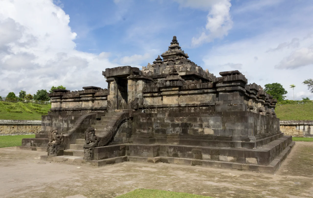
Descending into the Past
The experience of visiting Sambisari is unlike any other temple in the region. Visitors walk down a staircase on the western side, dropping 6.5 meters below the current ground level to reach the temple's base. The surrounding walls of excavated earth rise on all sides, framing the sky above in a way that makes the sunken temple feel like a secret the ground reluctantly gave up. The complex consists of a main temple and three smaller pervara guardian temples arranged in a row before it. Only the northeastern section of the outer retaining wall has been fully excavated; the rest remains underground, suggesting the full extent of the complex is still not entirely known. In the main courtyard, eight small lingga stand at the cardinal and corner points, marking the sacred geometry of the site.
Gods in the Walls
The main temple faces west and measures roughly 13.65 meters on each side. Its body rises 2.5 meters, with niches on three sides housing Hindu deities: Durga to the north, Ganesha to the east, Agastya to the south. Each niche is topped by the carved head of Kala, a demon face that serves as both decoration and spiritual guardian. The entrance on the western side was once flanked by statues of Mahakala and Nandisvara, though only their empty niches remain. Inside the main chamber sits a yoni stone measuring 1.34 meters across and 1.18 meters tall, with a waterspout on its north side supported by a carved Naga serpent. Atop the yoni rests a lingga, the phallic symbol of Shiva's creative power, 0.85 meters tall. Twelve stone bases in the surrounding gallery -- eight round, four square -- once supported wooden pillars, implying the temple was covered by a timber-and-thatch roof that has long since decayed.
What Else Lies Beneath
Sambisari's discovery electrified archaeologists in part because of what it implied about the broader landscape. If a complete temple complex could remain undetected for centuries under Merapi's volcanic blanket, what else might be down there? The question was not idle speculation. In 1994, sand diggers near the village of Kedulan struck the stone base of another buried temple at a depth of four meters. Only the main structure's foundation has been exposed; secondary temples remain underground. The Yogyakarta plain, fertile and densely settled, may conceal dozens of undiscovered sites beneath its rice paddies and villages. Each eruption of Merapi adds another layer of ash to the palimpsest, pushing the 9th-century ground level deeper, making the next discovery both less likely and more dramatic when it comes. Sambisari stands as proof that the earth here remembers what the surface has forgotten.
From the Air
Located at 7.76S, 110.45E in Sleman Regency, Special Region of Yogyakarta, approximately 8 km east of Yogyakarta city center. The temple sits in a sunken excavation pit that is not visible from the air, but the surrounding park and access road are identifiable. Mount Merapi (2,930 m) dominates the view to the north. Nearest airport: WAHH (Adisucipto International Airport), approximately 3 km to the east -- the temple is essentially under the airport's approach path. The Prambanan temple complex lies about 8 km to the east.
Nearby Stories
- The Ring of Fire's Restless Spine 8.4 km away
- Mount Merapi 13 km away
- Candi Sukuh 22 km away
- The Sultan Who Besieged the Future 37 km away
- Fort van den Bosch 44 km away
- The Ghost Boat That Built an Empire 131 km away
- Shaken Foundations: The 2021 East Java Earthquake 166 km away
- Mahameru: The Great Mountain That Never Sleeps 259 km away