The Ring of Fire's Restless Spine
Seventy-four thousand years ago, a volcano in northern Sumatra expelled 2,800 cubic kilometers of magma in a single eruption -- enough to blanket South Asia in ash and, some scientists argue, nearly extinguish the human species. The caldera it left behind is now Lake Toba, a serene body of water 100 kilometers long, surrounded by pine forests and small farming villages. That eruption was the signature act of the Sunda Arc, a volcanic chain stretching more than 3,000 kilometers from the northern tip of Sumatra to the island of Flores. This is the backbone of the Indonesian archipelago, and it has been building, erupting, and reshaping itself for millions of years.
Where Continents Collide
The Sunda Arc exists because the Indo-Australian Plate is diving beneath the Eurasian Plate at a rate of 63 to 70 millimeters per year. That may sound modest, but over geological time it has driven an ocean floor deep into the Earth's mantle, where intense heat and pressure melt rock into magma. That magma rises, and where it breaks the surface, volcanoes grow. Along Java, the subduction is nearly head-on -- orthogonal, in the language of plate tectonics -- producing a dense concentration of stratovolcanoes. Along Sumatra, the collision is oblique, and the subducting slab appears to fragment at depth. The two zones are separated by the Sunda Strait, where Krakatoa sits like a cork in a bottle between the islands. Beneath it all, 62 geothermal fields on Java alone hint at the enormous energy still trapped underground.
Eruptions That Changed the World
The Sunda Arc's volcanoes are not merely dangerous; several have altered global climate. In 1815, Mount Tambora on Sumbawa erupted with a force rated 7 on the Volcanic Explosivity Index, killing tens of thousands directly and triggering the "Year Without a Summer" across Europe and North America. The 1257 eruption of Mount Samalas on Lombok was equally powerful, depositing sulfate aerosols that cooled the planet for years. And then there is Krakatoa. When it erupted in 1883, the explosion was heard 5,000 kilometers away -- the loudest sound in recorded history. Tsunamis with run-up heights of 41 meters devastated coastal communities, and the atmospheric shockwave circled the globe multiple times. Today, Anak Krakatau, the child island born from that catastrophe, grows at an average rate of 13 centimeters per week, a restless reminder that the arc's work is far from finished.
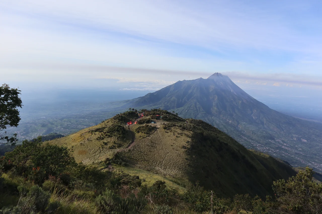
A Living Laboratory of Fire
Each section of the arc has its own volcanic personality. In East Java, eruptions tend toward the Plinian type -- towering columns of superheated debris that can collapse into deadly pyroclastic flows. Mount Bromo, one of the region's most active volcanoes, smolders inside the vast Tengger caldera, its plume visible for dozens of kilometers. Central Java is dominated by Mount Merapi, a steep stratovolcano whose lava dome periodically collapses, triggering explosive eruptions of andesitic material. Merapi's eruptive history stretches back 40,000 years, with significant events in 1994, 2006, and 2010. In West Java, volcanic activity dates to the Late Cretaceous, and geochemical studies of lava have confirmed steady-state subduction and ongoing magma replenishment for the past 10 million years. Far to the northwest, Mount Sinabung in North Sumatra -- just 40 kilometers from the Lake Toba supervolcano -- has been continuously active since 2013.
The Human Cost of Proximity
More than 150 million people live within the Sunda Arc's reach, and the consequences of that proximity have been devastating. On December 26, 2004, a magnitude 9.15 earthquake off the coast of Sumatra triggered a tsunami that killed more than 230,000 people across the Indian Ocean. In Banda Aceh, waves reached 35 meters high. Less than two years later, on July 17, 2006, a magnitude 7.7 earthquake off West Java sent a tsunami along 250 kilometers of coastline, killing more than 600 people. Hundreds of thousands have perished over the centuries in eruptions at Tambora, Krakatoa, Merapi, Kelud, Galunggung, and Agung. The arc's volcanoes also deposit rich minerals -- gold, copper, silver, zinc, lead -- in epithermal veins associated with magmatic activity, creating an uneasy bargain between geological wealth and geological peril.
The Arc from Above
From altitude, the Sunda Arc reveals its structure with startling clarity. The volcanic peaks form a line along the southern edges of Sumatra and Java, paralleling the deep trench offshore where the ocean floor plunges beneath the continent. On clear days, the conical silhouettes of Merapi, Bromo, and Semeru punctuate the horizon like a geologist's diagram come to life. The green patchwork of rice terraces climbs the lower slopes, giving way to bare rock and ash fields near the summits. Steam plumes rise from multiple vents simultaneously, a visible reminder that beneath this densely populated landscape, the mantle is always in motion and the next eruption is not a question of if, but when.
From the Air
Centered near 7.49S, 110.00E in Central Java. The arc stretches from northwest Sumatra (5N, 95E) to Flores (8.5S, 121E). Major volcanic peaks including Merapi (7.54S, 110.44E), Bromo (7.94S, 112.95E), and Semeru (8.11S, 112.92E) are visible from FL350 on clear days. Nearby airports: WARJ (Adisumarmo/Solo), WAHH (Ahmad Yani/Semarang), WARQ (Adisucipto/Yogyakarta). Volcanic activity may produce ash advisories -- check NOTAMs for SIGMET volcanic ash warnings across the region.
Nearby Stories
- Dieng Plateau: Where the Gods Reside Above the Clouds 0.1 km away
- Sambisari 7 km away
- The Fort That Changed Hands 8.8 km away
- 2010 Eruptions of Mount Merapi 9.8 km away
- The Fortress That Buried Itself 35 km away
- Sasana Wiratama 54 km away
- The Island of Flowers and Firing Squads 59 km away
- Kraton Kasepuhan 100 km away