San Francisco, Cundinamarca
The story is almost too neat to be true. In January 1857 a commission arrived at a scattering of twenty thatched houses on a mountain plain 52 kilometers northwest of Bogotá. They had come to decide whether this place deserved to be a municipality. The patron saint of the day, because it was January 29, was Saint Francis de Sales. The couple who had donated the land were named Francisca and Francisco Convers. The coincidence struck everyone present. By evening the village had a name: San Francisco de Sales. The parish had a patron. And a Cundinamarca town was born in a convergence of three Francises on a single afternoon.
Before the Name
Long before any Francises arrived, the mountain plain was a borderland. The Panches - a Carib-language people - lived on the hot western slopes. The Muisca, Chibcha-speakers of the high savanna, held the eastern flanks. On what is now San Francisco's southeastern edge, where it borders the municipality of El Rosal, the Muisca built a fort to keep the Panche from raiding up into the Confederation of Bacatá, the southern Muisca federation whose capital lay on the savanna below. Long before Spanish encomiendas, this was a frontier between two Andean civilizations. The Muisca called the land Chinga - a word that meant "wildness" or "bravery" in their Chibcha tongue, an admission that the country was difficult and the people who lived there were not easily conquered.
Chinga Fría, Chinga Caliente
After the conquest, an encomienda - a grant of indigenous labor - was assigned to a Spaniard named Juan de Vera, who named his property Chinga Fría. The naming is darkly funny in hindsight: in later Mexican Spanish chinga became a crude word, but in the 16th-century Chibcha sense it simply meant the wild land. Juan de Vera later exchanged Chinga Fría for a warmer property, which he called San José de Chinga Caliente - San José for the Christian patron, caliente to distinguish it from the cold one. The indigenous people assigned to those encomiendas lost their land and their autonomy in the exchange. Around 1750 Pedro Pulido of Tenjo bought the hacienda; in 1828 Francisca Sánchez of Tabio bought it from Pulido. In 1833 she married the French citizen Francisco Convers, and after 1850 the couple built a house on the grounds called La Carlina, replacing the by-then ruined colonial mansion.
One Afternoon in January
In 1855 Father Santos María Camero was made parish priest of nearby La Vega. Not long after his appointment, he was called up over the pass to Chinga Caliente to give last rites to a dying man. When he crested the ridge and the plain opened below him, he saw what he later described as a beautiful expanse - a landscape that should, he thought, have a town at its center. The local farmers had been asking for exactly that; the journey to La Vega for Mass, weddings, and civil affairs was long and difficult. Father Santos asked Francisca Sánchez de Convers to donate the land. She agreed. By 1856, 41 lots had been subdivided along a bridle path leading up toward the Yaque mountains, and 20 families had built thatched houses with clay tile and dirt floors. On January 29, 1857, the commission came to decide whether the village should be officially a municipality. It was the feast of Saint Francis de Sales. The owners were Francisca and Francisco. The name suggested itself.
Building a Town
The Archbishop of Bogotá formally created the parish by episcopal decree on August 15, 1857. On November 21 of the same year, the Cundinamarca State Assembly approved the new municipality, ordering the land expanded to nine hectares and the construction of public offices and a jail. The civil war of 1859 forced Francisca Convers to sell the hacienda; her successor, Dr. Senen Gutiérrez Castillo, delivered the promised nine hectares to Fray Blas Lombana in 1873. The first co-educational school opened in 1884. In 1895 Mayor Rogelio Alvarado and priest Florentino Sarmiento established a post and telegraph office. The first power plant opened in 1928 at the Quinta de San Luis, three kilometers from town. The current parish church, which now anchors the plaza, was built between 1943 and 1953 under Father José Arquímedes Castro.
El Jardín Encantado
Fifty-two kilometers from Bogotá, at about 1,500 meters elevation, with an average temperature of 20 °C and a páramo bajo climate - cool mornings, gentle afternoons - San Francisco has become a destination for one particular reason: the hummingbirds. El Jardín Encantado, the Enchanted Garden, is a private reserve inside the municipality where dozens of hummingbird species come to feeders set in tropical gardens. Birders arrive from across the Americas to see species found nowhere else at such density. The town itself remains small - roughly a third of the municipality's population lives in the town proper, with the rest spread across the rural districts of Arrayán, El Peñón, Juan de Vera, La Laja, Muña, Pueblo Viejo, Sabaneta, San Antonio, San Miguel, and Tóriba. The Convers hacienda is still there under its later name, La Carlina. The parish church still stands. The coincidence of names that founded the place has long since become simply the name of home.
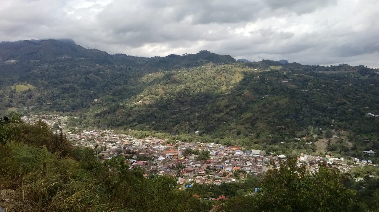
From the Air
San Francisco lies at 4.971°N, 74.289°W on the western flanks of the Eastern Range of the Colombian Andes, about 52 km northwest of Bogotá, at roughly 1,500 m elevation. The nearest major airport is Bogotá's El Dorado International (SKBO), from which it is about 75 km by road. From altitude, the municipality reads as rolling green farmland and scattered páramo cut by the San Miguel River and ringed by higher ridges; the cloud-forest belt on surrounding peaks is often misty. A small paved road from Bogotá via Facatativá and La Vega reaches the town. The area receives heavy rainfall (average 1,493 mm annually), so afternoon clouds are common.
Nearby Stories
- Sabana Formation 16 km away
- Magdalena Valley montane forests 39 km away
- Lake Iguaque 50 km away
- Valle de Cocora 65 km away
- Manizales 70 km away
- Villavicencio 71 km away
- El Infiernito 77 km away
- LaMia Flight 2933 98 km away