Sabana Formation
Bogotá is built on the bottom of a lake that isn't there anymore. For most of the Ice Age, the high valley now occupied by Colombia's capital was filled with Lake Humboldt - a cold body of water fed by glaciers from the Sumapaz páramo to the south. Around 30,000 years ago the lake began to retreat. When it was gone it left behind 320 meters of grey shale, lignite, and volcanic ash, embedded with the bones of Pleistocene mastodons and the butchered remains of their last meals. The Sabana Formation is that lakebed. The city sits on it. The roads crack because of it.
A Lake in the Andes
The Altiplano Cundiboyacense - the high plateau in the Eastern Range of the Colombian Andes - was formed during the final stage of Andean uplift in the Plio-Pleistocene. Before that last uplift, this region was a rift basin that had flooded periodically since Mesozoic time. When Miocene compression folded and thrust the rocks upward, the former seafloor became a plateau nearly three kilometers above sea level, trapped between mountain fronts. The depression at its center filled with water. Lake Humboldt, named for Alexander von Humboldt, who passed through these highlands in 1801, was the lake that Bogotá now stands on. The Sabana Formation is its uppermost sediment layer - horizontally bedded grey and greenish shales, lignites, diatomites, and repeated beds of volcanic ash that record eruptions on the surrounding ranges.
The Lake's Last Residents
During the final phase of Lake Humboldt, around the Last Glacial Maximum, the shoreline hosted populations of Pleistocene megafauna. Fossils of the giant ground sloth Megatherium have been found at Quipile; Eremotherium at Fusagasugá and Tocaima; Notiomastodon platensis, a South American mastodon, at Tocaima and Pubenza; the extinct horse Equus neogeus throughout the sediment. A fluorine-dated molar from a gomphothere in the Sabana Formation at Mosquera places that animal between the last interglacial and the start of the last glaciation. The fossils from Pubenza and Tibitó were dated at 16,300 and 11,740 years before present. Researchers at the Federal University of Rio de Janeiro have proposed that all gomphotheres found in Colombia should be reclassified into a single species: Notiomastodon platensis. The savanna was then cooler, the timberline 1,000 meters lower than today, and the páramo ecosystem stretched much farther down.
First People
About 12,500 years ago, the first confirmed humans in Colombia came to this landscape. At El Abra, Tibitó, and Tequendama - rock shelters at the edge of the retreating lake - small groups of hunter-gatherers sheltered, worked stone into tools, and used the bones of the still-extant Pleistocene animals for construction, tools, and clothing. They arrived as the lake was drying and the megafauna was going extinct. The people who sheltered in those rock shelters witnessed the end of that world. During the Holocene they moved out of the caves into open-air settlements like Checua and Aguazuque. About 5,000 years ago agriculture took hold: the fertile clays and volcanic ash of the Sabana Formation proved ideal for crops, and the bimodal rainfall - two wet seasons, two dry - suited growing. Pottery began about 2,800 years ago in what archaeologists call the Herrera Period.
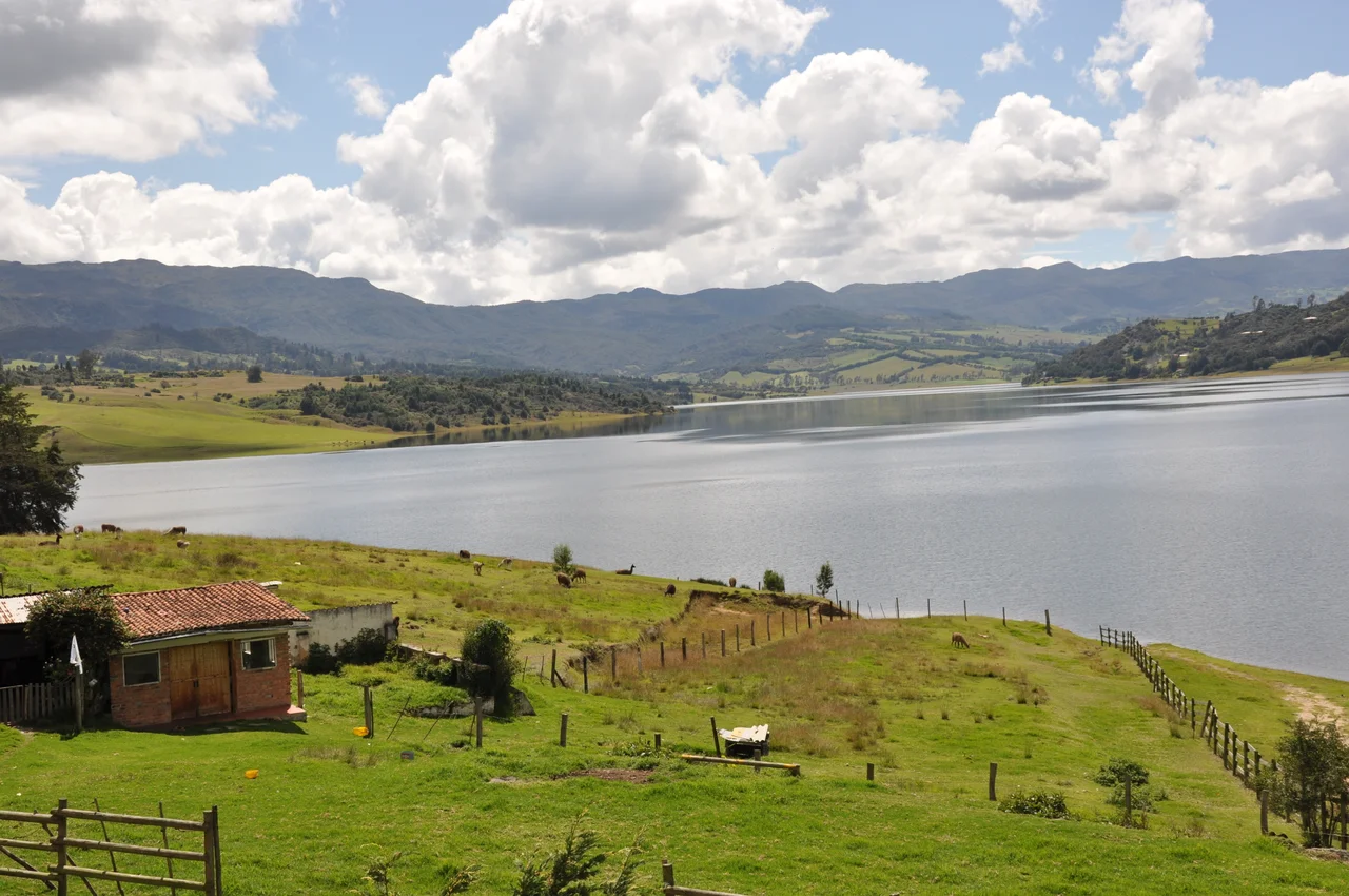
The Muisca Center
By the first and second millennia CE, an advanced civilization had grown on the savanna: the Muisca Confederation, a loose alliance of caciques governing much of the Altiplano. The southern Muisca territory centered on the Bogotá savanna, with its main settlement at Bacatá in the middle of the plain - the namesake of modern Bogotá. The clays of the Sabana Formation fed the pottery tradition that archaeologists still use to group and date Muisca sites; the northern settlement of Suesca was a major ceramic production center. The lakes of Fúquene, Herrera, and Suesca, and the wetlands that still dot the outskirts of modern Bogotá, are the last puddles of Lake Humboldt. The Muisca inherited the landscape the lake left behind. The Spanish who arrived in 1538, under Gonzalo Jiménez de Quesada, built their colonial capital on the same soft lake-bottom.
The City That Cracks
The foundation is not kind to modern construction. The northern neighborhoods of Bogotá - especially those north of Avenida Chile (Calle 72) in Chapinero and west of the Autopista Norte - sit on unconsolidated Sabana Formation shales that compact differentially under load. Sandy beds settle at one rate, clayey beds at another, and the roads built over them split into the fissures that anyone who has driven Bogotá's potholed north knows well. The older, historic center of Bogotá rests on the firmer Tunjuelo Formation - a fluvio-glacial unit deposited by the same glacial system that fed Lake Humboldt, but coarser and more competent. The Funza II well, on the western edge of the savanna, is the type locality where geologists first formally defined the Sabana Formation. Below every building in Bogotá north of Calle 72, a last thin layer of the Ice Age lake is still slowly giving way.
From the Air
The Sabana Formation underlies most of the Bogotá savanna at roughly 4.717°N, 74.217°W, at about 2,600 m (8,530 ft) elevation. From altitude, the savanna reads as a broad, flat, green plain tucked between the Eastern Hills (Cerros Orientales) on its east and lower ranges to the west. Nearest airport is El Dorado International (SKBO) near Fontibón, about 13 km west of Bogotá's historic center. Remnant wetlands of former Lake Humboldt are scattered across the plain as small ponds; the lakes of Fúquene, Herrera, and Suesca to the north are the larger survivors. Cloud cover is frequent and often heavy by midday, especially in rainy periods (April and October-November); mornings give the clearest view of the plateau.
Nearby Stories
- San Francisco, Cundinamarca 9.2 km away
- Villavicencio 36 km away
- Tolima Department 56 km away
- Valle de Cocora 64 km away
- Manizales 71 km away
- Lake Iguaque 85 km away
- Tunja 111 km away
- Valle del Cauca Department 245 km away