Valle del Cauca Department
Stand anywhere on the flat valley floor between the Cordillera Central and the Cordillera Occidental and you can see the geography of Valle del Cauca in a single sweep: green cane fields pressing outward for kilometers, both ranges of the Andes walling them in, and the Cauca River threading quietly through the middle. This is one of the most fertile places in Colombia. It is also where some of the country's oldest human stories - hunter-gatherers dating back 40,000 years, goldsmith chiefdoms, Spanish founders, and a port that now moves 8.5 million tons of cargo a year - have layered one on top of the next.
Two Ranges, One Valley
The department sits in Colombia's far west, bordering the Pacific Ocean. Four distinct zones divide it. The Pacific fringe is hot, humid jungle. The Cordillera Occidental rises behind it - also jungle-covered, though heavily deforested from paper-industry logging. Between the ranges lies the Cauca Valley itself, broad and astonishingly fertile. On the eastern side, the western slopes of the Cordillera Central climb toward coffee country. The Cauca River drains the whole system, fed by streams from both ranges. Offshore, the department also administers Malpelo Island, a bare volcanic rock 500 kilometers out in the Pacific that draws scuba divers from around the world to see its hammerhead shark schools.
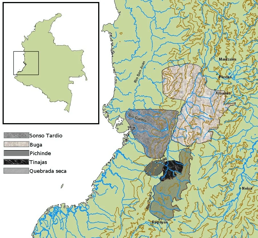
Forty Thousand Years of People
Pollen analysis of the Calima River basin tells a long story. During the late Pleistocene, between 40,000 and 10,500 years ago, Andean forest covered these valleys. Projectile points show that hunter-gatherers arrived before the ice age ended. By 5000 BC their descendants were cultivating maize. Around 1500 BC the Ilama culture emerged, living in small chiefdoms along the Calima River in what is now Restrepo and Darién. The Ilama gave way to the Yotoco by 100 AD - a stratified society whose goldwork, still famous in Colombian museums, shows just how skilled their metallurgy became. The Yotoco declined after the 6th century, replaced by the Sonso culture that the Spanish eventually met. When Sebastián de Belalcázar's expedition arrived from Quito in the 1530s, his captains founded Cali on July 25, 1536, on the edge of Gorrones territory.
Sugar, Ships, and Salsa
The valley's fertility shaped everything that came after. Belalcázar himself introduced sugarcane, and five centuries later the cane still dominates - enormous plantations feeding refineries that supply the country and export beyond. Coffee grows in the surrounding mountains. The industrial city of Yumbo, just north of Cali, houses more than 2,000 factories turning out paper and cement. On the Pacific coast, Buenaventura - often called Colombia's hardest-working city - handles the bulk of the country's Pacific trade. Cali itself, with around 2.8 million people, is the department capital and the world capital of salsa. The music leaks from open windows on most Friday evenings, spills out of clubs in the Juanchito district, and fills the streets every December during the Feria de Cali.
Six Cities That Don't Need Cali
Here is an unusual statistic: Valle del Cauca has six independent towns of more than 100,000 people that are not part of any metropolitan area. No other Colombian department comes close. Cartago, in the north, is famous for its hand-embroidery and the colonial Casa del Virrey. Roldanillo hosts a museum full of works by Omar Rayo, one of Colombia's most important modern artists. Tuluá sits at the geographic center. Palmira stretches across prime cane-growing land east of Cali. Buga draws Catholic pilgrims to its basilica of the Señor de los Milagros. Jamundí edges up against the Cauca Department border. Between them, 42 municipalities divide the valley floor and the mountain slopes, each with its own mayor, market day, and patron-saint festival.
Sancocho and the Herb That Makes It
Ask any vallecaucano what their region tastes like and the answer is sancocho de gallina - a stew of old hen, yucca, potatoes, corn, and plantain, simmered slow over wood fire. The trick is the herb. A wild cilantro-relative called cimarrón, or recao (Eryngium foetidum), grows on the valley floor and gives the broth its unmistakable sharp, almost metallic edge. No cimarrón, no real sancocho. You find the stew at roadside stands between Palmira and Buga, at family tables on Sundays, and at agrotourism haciendas that have turned former sugar estates into weekend escapes. The flavor tells you exactly where you are.
From the Air
Coordinates 3.93°N, 76.52°W (approximate department center). Valle del Cauca spans Pacific coast to the western slopes of the Cordillera Central, roughly 3°5'N-5°1'N latitude. Main airports: Alfonso Bonilla Aragón International (SKCL) serves Cali; Palmaseca (same facility) handles cargo. Buenaventura port is visible from the Pacific coast. The Cauca River runs north through the valley floor between the two Andean ranges - unmistakable as a navigation landmark. Malpelo Island (500 km offshore) is department territory but well out over the Pacific.
Nearby Stories
- Romeral fault system 45 km away
- Quindío Department 71 km away
- San José del Palmar 80 km away
- Popayán 139 km away
- Gorgona Island 155 km away
- Isla Gorgona 172 km away
- Gulf of Tribuga 174 km away
- San Vicente del Caguán 218 km away