Romeral fault system
Run a pen down the map of western Colombia and the cities line up along it like beads on a thread: Sincelejo, Medellín, Manizales, Pereira, Armenia, Cali, Popayán, Pasto. That line is the Romeral fault system - a 200-million-year-old scar where oceanic crust welded onto the ancient western edge of South America. The Cauca River fills the valley the fault carved. The Andes' Western and Central ranges rose on either side of it. And on March 31, 1983, and again on January 25, 1999, the fault briefly remembered it was still alive.
An Ancient Suture
The Romeral fault system has been moving since the Triassic - more than 200 million years. During the Cretaceous it was the western margin of northwestern South America, the literal edge of the continent before later mountain-building stitched additional crust onto it from the Pacific side. The fault today marks the boundary between obducted oceanic crust to the west and continental crust to the east, a suture zone visible in the rock: mid-ocean-ridge basalts, greenschists, Paleozoic metamorphics, and Triassic ultramafic intrusives, all jumbled together in what geologists call the Romeral Mélange. The 697 kilometers of the system in detail described, with 1,788 kilometers of cumulative length across its many parallel strands, run from Colombia's Caribbean lowlands south into Ecuador, where it continues under the name Peltetec Fault System.
Five Plates Meet Here
Colombia sits where five tectonic plates crowd one another: the Caribbean, the Panama, the Coiba, and the Malpelo (the last three formerly lumped into the Nazca plate), plus the North Andes plate that carries most of the country. The Romeral fault system tracks the seam where the North Andes plate has been welded together over geologic time. Its behavior is not simple. In the north of Colombia - above latitude 5° - the fault zone moves as a left-lateral (sinistral) reverse system. South of that, through Valle del Cauca, Cauca, and Nariño, it becomes mostly right-lateral (dextral). Scarps up to 400 meters high rise above Pleistocene sediments; older Cretaceous and Paleozoic rocks show eroded scarps, linear valleys, offset streams, and triangular facets - the classic surface signature of a long-lived strike-slip fault.
Volcanoes Overhead
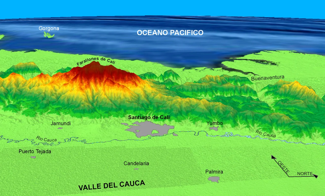
The active volcanoes of Colombia trace the fault zone. Galeras, which smokes above Pasto and has killed scientists at its crater, is underlain by the Romeral system. So is the Romeral volcano itself, which gave the system its name. So are the volcanoes of the southwestern chain running into Ecuador - Chiles and Cerro Negro de Mayasquer on the border, the volcanic flanks of the Central Range farther north. The tectonic depression that the fault zone carved in the central and southern sections has been filled by the Cauca River valley, Colombia's second most important fluvial artery after the Magdalena. The river's path through some of the most productive farmland in the country - sugar cane, coffee, cattle - exists because the fault made the valley.
Popayán, 18 Seconds
On Maundy Thursday morning, March 31, 1983, the Rosas-Julumito fault (or the nearby Julumito Fault, less than 2 kilometers west) slipped for eighteen seconds beneath Popayán. The magnitude was only Mw 5.5 - modest by global standards - but the quake struck a 400-year-old colonial city at the start of its most sacred week. The great dome of the cathedral came down. Hundreds died. Colombia's first seismic design code was written in response. Then, on January 25, 1999, the Córdoba-Navarco segment of the same fault system released a Mw 6.2 rupture beneath Armenia in Quindío Department. More than 1,000 people died. Combined, the 1983 and 1999 events killed over 2,000 - two strands of the same ancient system, waking up 16 years apart and destroying the capitals of Cauca and Quindío.
A System Still Moving
Individual segments slip at rates from 0.2 to a few millimeters per year. That seems slow - and it is, by human measure. But the fault has been moving for 200 million years, and the slippage accumulates. Strike-slip along Romeral has had at least three phases since the Miocene: right-lateral in the Late Miocene, left-lateral in the Pleistocene, then right-lateral again from the Pleistocene to the present, with a final left-lateral phase now visible in microseismic monitoring. The Quindío Fan near Armenia, some 400 square kilometers of volcanic and volcano-sedimentary Pleistocene deposits, is literally offset by the Montenegro Fault cutting across it. The Córdoba-Navarco fault, responsible for the 1999 Armenia quake, is still there. So is the Rosas-Julumito, still sitting under Popayán. And so are most of the major cities of the Colombian west, built on and across a scar that has been rearranging itself since before the dinosaurs.
From the Air
The fault system runs north-south through western Colombia at roughly 4.53°N, 75.68°W for its central segment, extending more than 700 km from Córdoba Department south to the Ecuadorian border. From altitude, its trace is most visible where it forms the straight western boundary of the Cauca Valley - a long, narrow lowland between the Western and Central Ranges, dotted with cities (Cali, Pereira, Manizales). The active volcanoes Galeras (near Pasto) and Nevado del Ruiz sit above or near the system. Nearest airports for overflight viewing are Cali's Alfonso Bonilla Aragón (SKCL), Armenia's El Edén (SKAR), and Manizales' La Nubia (SKMZ). Afternoon clouds frequently obscure the range - morning flights give the clearest view.
Nearby Stories
- Valle del Cauca Department 41 km away
- Manizales 45 km away
- Tolima Department 60 km away
- San Francisco, Cundinamarca 108 km away
- Tutunendo 114 km away
- Sabana Formation 116 km away
- Villavicencio 178 km away
- Gulf of Tribuga 182 km away