
Saronic Gulf
The ancient Greeks believed the Saronic Gulf took its name from a king named Saron, who drowned in the lake that once occupied its northern shore. Mythology aside, the gulf's real claim on history is harder to argue with: in 480 BC, in waters just west of the island of Salamis, the Athenian-led Greek fleet shattered Persia's navy in one of the most consequential battles of the ancient world. The same body of water that carries tankers and container ships to the refineries of Piraeus today once carried the fate of Western civilisation on an autumn morning.
Shape and Setting
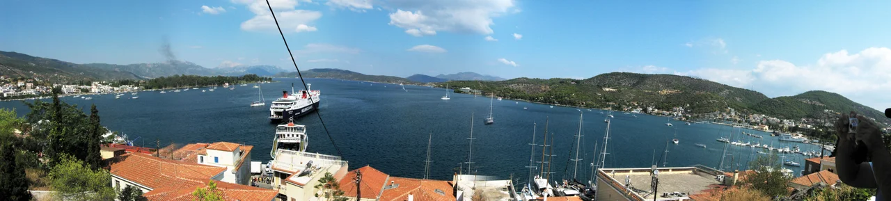
The Saronic Gulf is formed between the Attica peninsula to the north and east — where Athens sits along the northern coast — and the Argolis peninsula to the south and west. It opens into the Aegean Sea to the south. At its northwestern corner, the Corinth Canal connects the gulf to the Gulf of Corinth, cutting across the isthmus and making the Saronic Gulf the eastern terminus of one of the world's most dramatic shortcuts. The gulf encompasses the islands of Aegina, Salamis, and Poros as main bodies, with smaller islands including Patroklos and Fleves scattered through the water. Phaleron Bay, Elefsina Bay, Kechries Bay, and Sofiko Bay provide the main sheltered anchorages along its fringed coastline. The port of Piraeus — Athens' enormous commercial and passenger harbour — lies on the northeastern edge, alongside the site of the former Ellinikon International Airport, closed in 2001.
The Battle That Named an Era
On a morning in late September 480 BC, the Persian fleet of Xerxes I entered the Strait of Salamis expecting to finish off the smaller Greek force. The Athenian general Themistocles had chosen the ground carefully: in the narrow strait, Persian numerical superiority was a liability rather than an asset. The Athenian-led fleet, with roughly 370 triremes against a much larger Persian force, turned the confinement into a trap. The Persian fleet was broken. Xerxes, who had positioned a throne on the Attic shore to watch his victory, watched his defeat instead and withdrew from Greece. The Battle of Salamis, fought in these waters, contributed directly to Athens' subsequent rise as the dominant power of the classical Greek world — the city that built the Parthenon, codified democracy, and produced Plato, Sophocles, and Thucydides within a century of the battle.
A Gulf Built on Industry
The modern Saronic Gulf is one of the busier bodies of water in the eastern Mediterranean. Refineries cluster along the northern and northwestern coastline — east of Corinth, at Agioi Theodoroi, Eleusis, Aspropyrgos, Skaramangas, and Keratsini — producing most of Greece's refined petroleum products, much of which is then exported. Commercial shipping to those refineries, to Piraeus, and through the Corinth Canal keeps the gulf busy with freight traffic. On its geological underside, the northwestern part of the gulf sits on active fault lines. The volcano of Methana lies to the southwest, the youngest-active centre of the volcanic arc that runs through Milos, Santorini, and Nisyros. Its most recent eruption was a submarine event in the 17th century; the hot sulphurous waters that still rise at Methana feed a hydropathic institute that has operated for generations.
Sailing and What Lives Beneath
The Saronic Gulf is a popular sailing ground, partly because the Attic mainland provides partial shelter from the summer Meltemi wind — the northerly that can blow Force 7 and above further east in the Aegean islands. The gulf's winds are generally more manageable, making it accessible to smaller vessels and beginners. Beaches line much of the coastline, from Poros to Epidaurus on the Peloponnese side, from Megara to Eleusis and down from Piraeus to Anavyssos on the Attic shore. Below the surface, the gulf is a feeding and congregating ground for short-beaked common dolphins. In recent years, fin whales — among the largest animals on Earth — have been sighted in the gulf with increasing frequency, a sign that water quality has improved enough to attract animals that had been largely absent. The ancient theatre at Epidaurus and the Temple of Aphaia on Aegina mark the gulf's two most celebrated archaeological sites, visible from the water on clear days.
From the Air
The Saronic Gulf lies at approximately 37.70°N, 23.60°E, immediately south of Athens. From altitude, the gulf is unmistakable: a roughly triangular body of deep blue water bounded by the tan-and-grey Attic coast to the north and east, the Argolis peninsula to the west, and the open Aegean to the south. The island of Aegina is clearly visible near the centre of the gulf; Salamis is the elongated island close to the Attic shore near Piraeus. The Corinth Canal — a narrow cut just a few metres wide — can sometimes be spotted at the northwestern corner at higher altitudes. Recommended viewing altitude: 8,000–15,000 ft for full-gulf perspective. Nearest major airport: LGAV (Athens International Airport, Eleftherios Venizelos), on the northeastern shore.
Nearby Stories
- Museum of the Center for the Acropolis Studies 0.1 km away
- HMHS Britannic 2.3 km away
- Franchthi Cave 6.7 km away
- Great Sand Beach 8.4 km away
- Kythnos 15 km away
- Sanctuary of Apollo Maleatas 16 km away
- Loutraki 20 km away
- Hydra: The Island That Refused the Car 25 km away