Sawre Muybu Indigenous Territory
The Munduruku call the territory Daje Kapap Eipi, the place where the creator Karosakaybu made humanity and the Tapajos River from a tucuma seed. On the stretch of river they call the Fecho, where the Tapajos narrows, the river first emerged from the ground. These are not metaphors the Munduruku use for tourists. The sacred sites of Ilha da Montanha and the Fecho are specific locations inside the 178,173-hectare territory, and when Brazilian engineers proposed to flood seven percent of that land under the reservoir of the Sao Luiz do Tapajos Dam, the Munduruku responded by picking up a GPS and demarcating their own borders.
Where the River Was Born
The territory sits on the right bank of the Tapajos River in the southwest of Para state, bounded by the Tapajos to the west and its tributary the Jamanxim to the east. The land is composed of what Brazilians call terra preta, the fertile dark earth that indigenous agriculturalists built up over centuries of careful soil management. Archaeological work by Bruna Cigaran Rocha and Vinicius Honorato de Oliveira has shown that the middle Tapajos was occupied by the Munduruku long before the twentieth century, with nineteenth-century European accounts describing Munduruku villages along the river. The rubber economy pushed them out after 1900. When the rubber trade collapsed decades later, in the 1970s, the Munduruku returned to the Fecho and rebuilt their lives in the place where their creation story says they began.
The Dam Downstream
The proposed Sao Luiz do Tapajos Dam would have been one of the largest hydroelectric projects ever built in the Amazon. Its reservoir, at 729 square kilometers, would have submerged thirteen thousand hectares of the Sawre Muybu territory, including the village of Boa Fe. Upstream, the proposed Jatoba Dam would have put the territory between two reservoirs, and the proposed Cachoeira do Cai Dam on the Jamanxim would have flooded its eastern border. The entire Tapajos hydroelectric complex, if built, would have affected at least 32 communities and two thousand square kilometers of indigenous land. In January 2012, President Dilma Rousseff reduced the protected boundaries of Itaituba II National Forest, removing a legal obstacle to flooding the area the Munduruku had reoccupied.
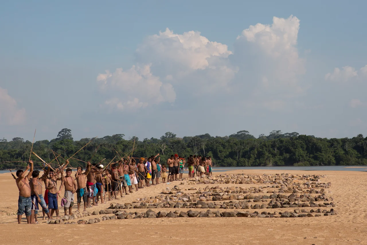
Self-Demarcation
FUNAI, the federal agency responsible for indigenous affairs, had begun the formal demarcation process for Sawre Muybu in 2007. The detailed identification study was finished in September 2013, with findings that the state was constitutionally obligated to recognize the territory. Publication stalled. In 2014, with FUNAI refusing to make the report public, the Munduruku began marking the borders themselves, an act they called autodemarcacao. The Ipereg movement, the Munduruku-led organizing body behind the effort, received a United Nations award for its self-demarcation work at the end of 2015. Thirteen thousand Munduruku live along the Tapajos and its tributaries, and their position was consistent: they would not accept the five dams, and they would not relocate. The creation story does not allow for the river to be dammed at the place where it was born.
The Signs They Put Up Themselves
In June 2016, the Munduruku announced they would install about fifty signs along the boundaries of the territory declaring that the area was protected and access by strangers was forbidden. Environmental activists helped. When journalists asked FUNAI whether the signs were legal, the agency would only say that the demarcation process was in a ninety-day public challenge phase. The Munduruku's calculation was straightforward. They knew the reservoir of the Sao Luiz do Tapajos Dam, as designed, would flood at least four hundred square kilometers of their territory. They knew the 1988 Brazilian Constitution prohibits removing indigenous people from their traditional lands. They also knew what had happened to the people displaced by the Tucurui Dam on the Tocantins thirty years earlier, still waiting for the compensation they had been promised.
What Recognition Forced
On April 17, 2016, the Brazilian Chamber of Deputies voted to impeach President Dilma Rousseff. Two days later, on April 19, FUNAI finally published the identification and delimitation study for Sawre Muybu that had been sitting on a shelf for two and a half years. On the same day, the federal environmental agency IBAMA suspended licensing for the Sao Luiz do Tapajos Dam. IBAMA said the timing was coincidental. No one involved with Munduruku advocacy believed that. The published study made the dam unconstitutional because the Constitution forbids flooding demarcated indigenous land, and in August 2016, IBAMA formally canceled the environmental license. The largest hydroelectric project proposed for the Amazon in decades was dead, killed by the persistence of a people who had returned to a place their ancestors had been driven from and refused to leave it a second time.
The Decree Signed
Recognition is not demarcation, and demarcation is not a presidential decree. In November 2016, indigenous leaders from the Indigenous Missionary Council and Greenpeace environmentalists occupied the Ministry of Justice in Brasilia, placing 180 arrows on the ministry's lawn to mark the 180 days that had passed since the demarcation report's legal deadline. A FUNAI official told them the agency had not anticipated how hard the final step would be. On September 25, 2024, Brazil's Minister of Justice Ricardo Lewandowski signed the declaratory decree delimiting the boundaries of the Sawre Muybu Indigenous Land - a victory the Munduruku had fought for over seventeen years. The Munduruku continue to live in the Fecho, to fish in the river that was born from the tucuma seed, and to hold the ground their ancestors walked. The dams have not been built. The land has now been formally demarcated - though threats persist, including renewed hydroelectric studies authorized by ANEEL and the proposed Ferrogrão railway planned without indigenous consultation.
From the Air
Located at 4.89 degrees S, 56.59 degrees W on the middle Tapajos River in the state of Para, in the municipalities of Itaituba and Trairao. The territory runs between the Tapajos and its tributary the Jamanxim, covering 178,173 hectares. Nearest airport is Itaituba Airport (SBIH), about 80 km north. Best viewed from 5,000 to 10,000 feet where the bright blue-green of the clearwater Tapajos contrasts with the muddy Jamanxim and the forest canopy around them. Sacred sites of the Fecho and Ilha da Montanha lie within the territory boundary.
Nearby Stories
- Amazonia National Park 48 km away
- Jatobá Hydroelectric Power Plant 55 km away
- Jamanxim National Park 72 km away
- Fordlândia 93 km away
- Cachoeira dos Patos Dam 120 km away
- Alto Maues Ecological Station 146 km away
- Crepori National Forest 185 km away
- Amazon Tall Tower Observatory 353 km away