Serra dos Órgãos
Fifty kilometers north of downtown Rio de Janeiro, on a clear day, a row of jagged granite towers stands out against the horizon like the teeth of a stone comb. One of those towers has been visible from the city since the Portuguese first built there, and it has had a name - Dedo de Deus, God's Finger - for almost as long. The Serra dos Órgãos is the range that carries that finger and about two dozen other named peaks, an escarpment 20,024 hectares in extent that forms the northern edge of the Guanabara Graben. The rocks are more than 600 million years old. The vertical relief is closer to 2,200 meters from the coastal plain to the highest summit. Between those two numbers sits the geological story of how a piece of the Brazilian Shield was shattered into something that resembles the pipes of a cathedral organ.
The Name That Stuck
The name predates modern Brazil. Early Portuguese settlers, climbing inland from the coastal settlements that would become Rio de Janeiro, saw the row of vertical rock towers along the escarpment and compared them to the pipes of church organs - the large wooden and metal instruments that anchored the acoustic life of the cathedrals they had left behind. The comparison was observational, not poetic. The towers actually do stand in ranked lines, with similar heights and spacing, shaped by the same geological processes that produced the vertical fractures in the granite. The name Serra dos Órgãos appeared in early maps and never left. Today the range contains Serra dos Órgãos National Park, protecting about half of the mountain's total area, and the mountain's silhouette still appears on postcards sold in Rio, where the God's Finger peak makes a cameo on the state flag.
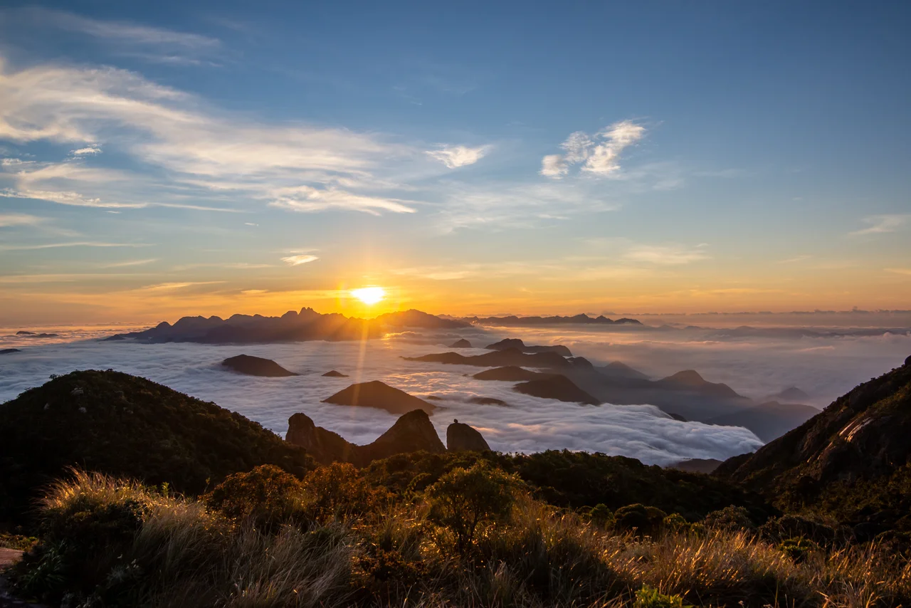
From Sea Level to 2,263 Meters
The escarpment is remarkable for what it does in a short horizontal distance. The altitude ranges from near sea level in the coastal plain to 2,260 meters above sea level just four kilometers inland. Average elevation across the plateau is around 1,100 meters. The highest point is Pedra do Sino, Bell Rock, at 2,263 meters. Dedo de Deus sits at 1,692 meters, and its neighbor Escalavrado at 1,490 meters. These named peaks, along with the nearby rock walls, can be seen on a clear day from Rio de Janeiro itself, 50 kilometers distant. The range forms an almost vertical wall on its seaward side - the reason it appears so dramatic from a distance, rising almost without foothills from the Baixada Fluminense lowland. Between Petrópolis and Teresópolis, the escarpment runs east-west across the central part of Rio de Janeiro state. The two cities sit at altitude on the plateau above the wall; the highway connecting them winds up the face.
The Dike That Made God's Finger
The reason Dedo de Deus looks like a finger and not a rounded hill is a quirk of differential erosion. The mountains of the Serra dos Órgãos are mostly granitic gneisses of the Neoproterozoic era - metamorphic rocks formed around 620 million years ago. But the specific ridge containing God's Finger and the other vertical towers is held up by a thick dike of Cambrian granite. The dike intruded into the older orthogneiss after the metamorphism was complete, and the younger granite proved more resistant to weathering. As the softer gneiss around it wore away over hundreds of millions of years, the dike remained standing. What is visible today is essentially the dike, denuded. A northwest fracture system defines the primary ridge-and-valley orientation; northeast fractures cross those at right angles, spaced about every 500 meters. Erosion along these intersecting fracture sets has isolated the blocks that the Portuguese colonists saw as organ pipes.
The Night of November 1981
The proximity of the Serra dos Órgãos to Rio de Janeiro is both its main touristic attraction and its main source of risk. In November 1981, intense rainfall over several days saturated the steep slopes. On one night in particular, the accumulated water triggered hundreds of shallow landslides across the range. Slides of mud, rocks, and forest debris ran off the mountainside into the valleys below. The BR-116 highway, the primary north-south artery that passes through Serra dos Órgãos National Park, was blocked. About 20 people were killed. The disaster was a warning about what the steep Atlantic Forest escarpments can do when precipitation exceeds the soil's capacity to hold it. Similar events have struck this stretch of the Serra do Mar more than once in the decades since, with the 2011 floods in the Região Serrana of Rio de Janeiro - slightly further north - killing more than 900 people in a single night. The mountains that look like organ pipes from a safe distance contain real hazards up close.
Painted by the Wandering Germans
The Serra dos Órgãos has a visual record older than most Brazilian landscapes. Johann Moritz Rugendas, the German painter who traveled Brazil in the 1820s documenting everything he saw for European audiences, painted the range during his time in Rio. His image shows the peaks rising above a flat coastal foreground, the characteristic silhouette already recognizable. Sixty years later, the German-Brazilian painter Georg Grimm produced his oil canvas Vista de Teresópolis, showing the range from the plateau side as a sweep of cloud-wrapped ridges. These paintings matter because they preserve a specific kind of evidence: the mountains looked this way then, and they look this way now. The Atlantic Forest that clings to the slopes is reduced compared to Rugendas's era, but the granite itself is unchanged. The organ pipes stand where the Portuguese colonists first named them, where the Tupi peoples who preceded them first lived among them, where the geology that shaped them set them down more than 600 million years ago.
From the Air
The Serra dos Órgãos range is centered at 22.42 degrees south, 42.75 degrees west, forming the northern rim of the Guanabara Graben between Petrópolis and Teresópolis about 50 km north of Rio de Janeiro city. The escarpment rises from near sea level in the Baixada Fluminense to 2,263 m at Pedra do Sino. Recommended viewing altitude 8,000-10,000 ft AGL for clearance over the highest peaks. The vertical granite towers including Dedo de Deus (1,692 m) are visible from the city of Rio de Janeiro itself on clear days. BR-116 highway climbs the escarpment and is useful for navigation. Rio de Janeiro Galeão (SBGL) is about 55 km south; Santos Dumont (SBRJ) is about 50 km south. Expect afternoon buildups of clouds along the ridge; morning viewing typically clearest.
Nearby Stories
- Miguel Pereira 24 km away
- Macaé 41 km away
- Desengano State Park 43 km away
- Juiz de Fora 46 km away
- Rio de Janeiro 54 km away
- Leopoldina, Minas Gerais 69 km away
- Basilica of Our Lady of Aparecida 205 km away
- Grytviken 3546 km away