
Sharp Island
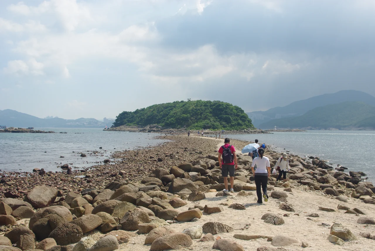
Twice a day the tide goes out and a causeway appears. Sand and gravel deposited by sea currents over millennia form a tombolo — a natural bridge — connecting Sharp Island to its smaller neighbour Kiu Tau. When the water level at Ko Lau Wan drops to 1.40 metres or below, visitors can walk across it. When the tide returns, the bridge disappears beneath the surface and the two landforms become islands again, separated by harbour water. It is a daily geology lesson played out at walking pace, and it is one of the reasons this small island — 1 km² at its widest — anchors one of the most visited sections of the Hong Kong UNESCO Global Geopark.
Rocks Shaped by Fire, Then Sea
About 140 million years ago, in the Cretaceous period, a volcano erupted in what is now Sai Kung. Sharp Island sat on the margin of the caldera — the collapsed crater that forms after a volcanic eruption drains its magma chamber. This position explains why the island carries such a variety of volcanic rocks from different geological periods: lava flows, ash deposits, and volcanic debris from eruptions spanning millions of years are all present here, compressed into a landscape barely a kilometre across. Two rock types catch the eye most readily: those with distinctive surface patterning, and those with an unusual rounded form sometimes described as pineapple-shaped. The Sharp Island Special Area, designated in 2011 and covering 649 square metres west of the Kiu Tsui Beach pier, was set aside specifically to protect these Cretaceous volcanic formations.
Half Moon Bay and the Coral Below
Sharp Island has two beaches. Half Moon Bay — known in Cantonese as Hap Mun Bay, a name that describes the crescent shape of the shoreline — and Kiu Tsui Beach bracket the island's most accessible coast. Below the waterline surrounding the island, over 70% of the seabed has stony coral coverage, making Sharp Island's waters among the most coral-rich in Hong Kong. Divers come for this; so do fish. The combination of rocky reef, coral, and clear water in the sheltered anchorage of Port Shelter has made Sharp Island well known in Hong Kong diving circles for decades. Swimming from the beaches is also popular, and the island draws day-trippers who arrive by kai-to — the small ferries that run from Sai Kung Town pier across the mouth of Port Shelter.
The Tombolo and Kiu Tau
The tombolo that connects Sharp Island to Kiu Tau is the island's most distinctive feature and the image most associated with it in photographs. Tombolos form when longshore currents deposit sediment in the wave shadow of an offshore island, gradually building a ridge of material until it reaches the surface. The one at Sharp Island is made of mixed rock and sand, and its width and stability vary with season and storm. At low tide it is broad enough to walk confidently; children run across it. At high tide it vanishes, and the approach by water makes it invisible from the surface. The experience of crossing it — the water close on both sides, the island ahead, the geological forces that made the crossing possible taking tens of thousands of years to do what the tide undoes twice daily — is one of those encounters that makes a place memorable.
Getting There and the Geopark Context
Sharp Island belongs to the Kiu Tsui Country Park and falls within the Hong Kong UNESCO Global Geopark, a status that recognises the geological significance of the volcanic and sedimentary formations across eastern Hong Kong. The island has no permanent residents and no road access. The only way to reach it is by kai-to from Sai Kung Town, a journey of perhaps fifteen minutes across sheltered water. Sai Kung Town itself — a waterfront settlement known for its seafood restaurants and lively promenade — is the gateway to a broader network of islands and coastal parks that represent Hong Kong at its least urban. An endangered plant species, Tetrathyrium subcordatum, has been recorded on the south of Sharp Island, adding a botanical dimension to a landscape already remarkable for its geology and marine life.
From the Air
Sharp Island (Kiu Tsui Chau) lies at approximately 22.361°N, 114.295°E in Port Shelter, off the Sai Kung Peninsula in eastern Hong Kong. At 136 metres maximum elevation, the island's ridgeline is visible from moderate altitude as a green hump rising from the blue-green waters of Port Shelter. Approaching from the west at 2,000 feet, the tombolo connecting the island to Kiu Tau may be visible at low tide as a pale sand bar. The Sai Kung Peninsula's jagged coastline and the scatter of islands in Port Shelter make this one of the most visually distinctive areas of Hong Kong from the air. Hong Kong International Airport (VHHH) is approximately 35 km to the west-southwest. The former Kai Tak airport approach path passed north of this area. Helicopter services operate from the Sai Kung peninsula; commercial approaches to VHHH use the western corridors.
Nearby Stories
- Sha Chau and Lung Kwu Chau Marine Park 5.9 km away
- Wanshan Archipelago 22 km away
- Hong Kong 12 25 km away
- Second Battle of Chuenpi 27 km away
- Mount Guanyin (Dongguan) 43 km away
- Battle of Penghu 474 km away
- Penghu Air Raids 482 km away
- Checheng Fu'an Temple 592 km away