Similajau National Park
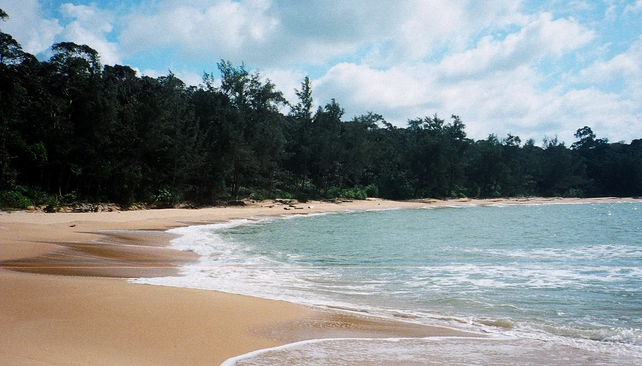
Early morning on the Likau River, and the water is glass. Then a dorsal fin breaks the surface -- not one, but four, moving in formation. Irrawaddy dolphins, stub-nosed and grey, rolling through the brackish water where the river meets the South China Sea. Somewhere upstream, a saltwater crocodile lies submerged along the bank, only its eyes and nostrils visible above the waterline. This is Similajau National Park, a narrow strip of Sarawak coastline about 30 kilometers northeast of the industrial town of Bintulu, where one of Borneo's most diverse coastal ecosystems survives in a corridor barely wider than a few kilometers. Established in 1976, expanded in 2000, and still relatively unknown outside Malaysia, Similajau packs an improbable density of life into its 89.96 square kilometers of beach, cliff, mangrove, and rainforest.
Three Forests in One
Similajau's vegetation divides into three distinct zones, stacked from shore to interior like layers of a geological cross-section. Along the coast, beach forest clings to sandy soil -- salt-tolerant species tough enough to survive the South China Sea's spray and monsoon winds. Behind it lies kerangas, the Iban word for heath forest, a habitat unique to Borneo's nutrient-poor sandy soils. Kerangas trees grow shorter and more densely packed than their lowland cousins, and among them thrives the tongkat ali, a slender tree that produces clusters of bitter red fruits that blacken as they ripen. Similajau has more tongkat ali than any other national park in Sarawak. Deeper still, mixed dipterocarp forest takes over -- the towering canopy of Borneo's ancient lowlands, where trees reach 60 meters and the understory dims to a green twilight. The bintangor, a species found in both hill and swamp forest, marks the transition zones between these habitats.
The River's Residents
The Likau River, which forms the park's southern boundary, hosts two species of crocodile that could not be more different in temperament. The saltwater crocodile -- the largest living reptile -- is aggressive and has been responsible for numerous fatal attacks in Sarawak. Visitors are warned to stay well back from the riverbanks. The false gharial, by contrast, is shy and slender-jawed, a fish specialist that avoids confrontation, though rare fatal encounters have been documented in Central Kalimantan and Sumatra. Both species patrol the same waterway, a coexistence that speaks to the richness of the Likau's food web. During the dry season, from May to October, horseshoe crabs emerge from the river to breed along the shore, the smaller males clasping the larger females as they crawl up the beach to lay eggs. Sagor catfish gather to feed on the eggs -- an annual feast that has likely played out here for centuries.
Wings and Waves
Above the canopy, 185 bird species have been recorded within the park. Eight species of hornbill live in Sarawak, and Similajau shelters both the rhinoceros hornbill -- the state bird, with its heavy casque and booming wingbeats -- and the smaller black hornbill. The critically endangered Storm's stork, one of the rarest waterbirds in Southeast Asia, has been spotted here among the park's migratory visitors. In the waters offshore, five dolphin species have been documented in Bintulu's coastal zone: the Irrawaddy dolphin, bottlenose dolphin, Indo-Pacific humpback dolphin, finless porpoise, and pantropical spotted dolphin. Groups of four or more are often seen during early mornings from March to September, surfacing in the shallows where the continental shelf drops away. Green sea turtles come ashore at Turtle Beach -- two stretches of sand about six kilometers from the park office -- to lay their eggs during the same months the dolphins are most visible.
Trails to the Edge
Similajau is a park built for walking. The main trail, marked in red, runs 9.8 kilometers along the coast to Golden Beach, threading between forest and shoreline. Shorter routes branch off: the education trail leads 450 meters along a mangrove plank walk before connecting to a 600-meter jungle path where park staff identify tree species. The Batu Anchau trail ends at a black rock surface two kilometers from the park office -- a slab of dark stone exposed by erosion, slick with spray. The Selunsur Rapids trail stretches 6.8 kilometers to a set of cascades that only reveal themselves after heavy rain. And offshore, about four kilometers from Kuala Sungai Likau, the rock formation called Batu Mandi appears during low tide, accessible only by boat. The natural pool at Sebubong River, also reachable by boat, offers swimming in clear freshwater surrounded by forest. Each trail reveals a different facet of the park -- mangrove, heath, dipterocarp, shore -- and together they map the full range of Similajau's compressed diversity.
A Thin Green Line
Similajau's shape tells its story. The park is a narrow coastal strip, originally 70.64 square kilometers stretching 30 kilometers from the Likau River in the south to the Similajau River in the north. On February 17, 2000, an additional 19.32 square kilometers was incorporated, expanding the total to 89.96 square kilometers. But the park remains long and thin -- a buffer between the South China Sea and the logged, planted, and developed land behind it. Bintulu, its nearest town, is an industrial center built on the natural gas and timber industries. That proximity makes Similajau both accessible and vulnerable. The 24 mammal species recorded here, including gibbons, banded langurs, and long-tailed macaques, depend on forest corridors that extend beyond the park's borders. For now, the dolphins still surface in the morning light, the turtles still haul themselves onto the sand, and the hornbills still crash through the canopy overhead. The park holds its line.
From the Air
Coordinates: 3.42N, 113.23E, on the coast of Sarawak, Malaysian Borneo, facing the South China Sea. Best viewed from 3,000-5,000 feet to see the narrow coastal park stretching between the Likau and Similajau rivers, with golden beaches and dark rainforest meeting turquoise coastal waters. Nearest airport: Bintulu Airport (WBGB), approximately 30 km southwest. The park's long, thin coastal shape is distinctive from the air. Tropical maritime climate; mornings are clearest. Visible landmarks include the rocky headlands, river mouths, and the contrast between park forest and surrounding cleared land.
Nearby Stories
- East Malaysia 21 km away
- Niah National Park 47 km away
- Twenty-Nine Minutes Over Borneo 57 km away
- Crown Colony of Sarawak 62 km away
- Baram Dam 74 km away
- Luconia Shoals 248 km away
- Fort Alice 264 km away
- The White Rajahs of Sarawak 348 km away