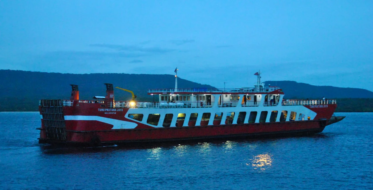
The Three-Minute Crossing: The Sinking of KMP Tunu Pratama Jaya
The Bali Strait is only four kilometers wide at its narrowest point. Ferries cross it dozens of times a day, shuttling passengers and vehicles between Java's eastern tip and Bali's western shore. The voyage from Ketapang to Gilimanuk takes roughly thirty minutes -- so routine that locals treat it like a commute. On the night of July 2, 2025, the roll-on/roll-off ferry KMP Tunu Pratama Jaya left the Ketapang dock at 10:56 PM with 53 passengers, 12 crew members, and 22 vehicles lashed to its decks. Thirty minutes later, it was gone. The ship capsized and disappeared beneath the surface in approximately three minutes, faster than most passengers could find a life jacket, faster than the crew could launch an organized evacuation, faster than the mind can process the transformation of a steel vessel into a death trap.
Rough Water, Open Door
The seas that night were running two to two-and-a-half meters, heavy but not unprecedented for the strait. The Tunu Pratama Jaya, a 734-gross-ton vessel built in 2010, had been cleared for departure with its safety aspects declared suitable. Around 11:15 PM, roughly twenty minutes into the crossing, the officer on duty detected a leak in the engine room and sent a distress signal on radio channels 17 and 18. What happened next unfolded with sickening speed. Water poured through the open engine room door. The ship began listing to starboard. Vehicles at the stern -- heavy trucks and pickups -- shifted toward the low side, compounding the tilt. The captain, who had been resting, was woken and took the helm, but the physics had already turned fatal. Passenger Bejo Santoso later described the ship rolling three times before going under. In pitch darkness, with waves crashing over the listing deck, passengers scrambled for life jackets or simply jumped.
Darkness on the Strait
Nearby vessels turned their searchlights toward the sinking coordinates, but night and heavy seas conspired against them. Floating objects -- debris, bodies, survivors clinging to wreckage -- were nearly invisible in the dark water. Some passengers managed to grab scattered life jackets. Others were pulled under by the suction of the sinking hull or struck by vehicles tumbling off the decks into the sea. Fishermen were among the first to reach survivors, followed by Indonesia's National Search and Rescue Agency, Basarnas. The joint search operation would continue for thirteen days, extended three times as bodies continued surfacing. By July 20, the toll stood at 30 rescued, 19 confirmed dead, and 16 still missing. The mathematics of the passenger manifest -- 65 souls aboard, 49 accounted for -- left families in a limbo worse than certainty, scanning the strait's surface for news that grew less likely with each passing day.
The Weight of What Went Wrong
Investigators from the National Transportation Safety Committee, known by its Indonesian acronym KNKT, began a three-phase investigation that focused on questions both mechanical and human. Why was the engine room door open in rough seas? Had the vessel been overloaded with vehicles beyond its manifest? Were the trucks and pickups properly secured, or had lax lashing allowed the fatal cargo shift? The ship's last docking inspection had been in October 2024, and the Sailing Approval Letter was under scrutiny. Indications of non-manifest loading -- vehicles aboard that weren't officially recorded -- suggested a broader pattern of regulatory shortcuts on a crossing so routine it bred complacency. The East Java Regional Police questioned surviving crew members and passengers, probing the chain of decisions that sent a loaded ferry into heavy seas on a dark night with an engine room door that should have been sealed.
A Nation's Reckoning
The political response was swift and pointed. Commission V of the Indonesian House of Representatives summoned the Minister of Transportation, demanding an explanation for how a ship could sink just miles from port on one of the country's busiest ferry routes. The irony was bitter: the Bali Strait crossing is so short that passengers barely have time to settle in before arrival. Yet that brevity provided no safety margin when things went wrong -- thirty minutes of sailing left the vessel in the middle of the strait, too far from either shore for a quick rescue. President Prabowo Subianto, performing the Umrah pilgrimage in Saudi Arabia, ordered an immediate emergency response from thousands of miles away. The Ministry of Transportation opened a coordination post at Gilimanuk Port, marshaling the navy, police, state ferry company ASDP, and local search-and-rescue teams. Indonesia has a long and painful history of ferry disasters -- the archipelago's 17,000 islands make maritime transport essential, but oversight has struggled to keep pace with demand. Each sinking prompts calls for reform. Whether the Tunu Pratama Jaya will prove a turning point or another entry in a recurring tragedy remains an open question.
The Strait Remembers
The Bali Strait continues its ceaseless traffic. Ferries depart Ketapang and Gilimanuk on schedules unchanged since the sinking, carrying the same mix of commuters, tourists, trucks, and motorbikes across waters that hide the Tunu Pratama Jaya's wreckage below. For the families of the sixteen people still listed as missing, the strait is no longer a crossing but a grave without a marker. The speed of the disaster -- three minutes from capsize to submersion -- haunts the survivor accounts most of all. There was no time for the rituals of emergency: no orderly evacuation, no lifeboats deployed, no calm instructions over a public address system. There was only the lurch, the darkness, the cold water, and the choice between jumping and going down with the ship. In a nation of islands, where water is both highway and horizon, the sinking of the Tunu Pratama Jaya is a reminder that the sea does not forgive complacency, and that the shortest crossings can exact the highest price.
From the Air
Located at 8.16°S, 114.42°E in the Bali Strait between Java and Bali. The sinking site lies roughly midway across the strait, which is approximately 4 km wide at its narrowest point. From altitude, the strait is clearly visible as the narrow channel separating Java's eastern tip from Bali's western coast. Port of Ketapang on the Java side and Port of Gilimanuk on the Bali side are both visible along the shoreline. Nearest airports include Banyuwangi's Blimbingsari Airport (BWX/WARB) approximately 15 km west on Java and Ngurah Rai International Airport (DPS/WADD) approximately 130 km southeast on Bali's southern tip. The strait experiences strong currents and can be rough, particularly during the monsoon season. West Bali National Park's forested coastline is visible to the east.
Nearby Stories
- Bali 8.2 km away
- Java's Little Africa 11 km away
- When the Island Shook 15 km away
- Alas Purwo: Where Java Begins and the Surf Never Stops 28 km away
- Meru Betiri: The Last Forest on Java's Southern Edge 30 km away
- The Ship of Four Names 58 km away
- The Kedopok War: When Probolinggo Rose Against Its Buyer 78 km away
- Shaken Foundations: The 2021 East Java Earthquake 153 km away