
Solway Firth
The name 'Solway' first turns up in writing in 1218, as Sulewad. It probably comes from the Old Norse súl, meaning 'pillar,' referring to the Lochmaben Stane — a large boulder that marked the ford across the mud flats at the mouth of the Esk. Names like that get attached to crossings that have killed people, because the Solway is full of patches of quicksand that shift with every tide. A ford was useful precisely because it had been worked out by people who had tried other places and died trying. The pillar told you where to start. Whether you reached the other side was up to the firth.
Where Two Countries Meet
The Solway Firth divides Cumbria from Dumfries and Galloway, England from Scotland. The Isle of Man sits just south. It is part of the Irish Sea, but it functions as a borderland in a way that goes deeper than geology — for centuries the firth has shaped what could and could not move between two countries, and what could and could not be smuggled across when the official routes closed. Most of the firth's coast is rural: small villages like Powfoot, hill farming, some arable farming, and a growing tourism trade. The lowland hills and small mountains that line the inlet are not dramatic by Lake District standards, but they make for some of the largest open skies you can find in Britain. Half of any view from the Solway is sea, sky, and the other country.
The Worm and the Wind
Within the firth, salt marshes and mud flats reach out under the water and shift their patterns of quicksand. They are dangerous, and locals will tell you so. They are also extraordinarily rich in wildlife. There are over 290 square kilometres of Sites of Special Scientific Interest in and around the firth, plus national nature reserves at Caerlaverock on the Scottish side and in Cumbria on the English. The Solway Coast Area of Outstanding Natural Beauty was designated in 1964 and runs in two sections along the Cumbrian shore. In 2013, conservation efforts focused on the honeycomb worm and the blue mussel, with Allonby Bay put forward as a candidate Marine Conservation Zone. Construction of the Robin Rigg Wind Farm in the firth itself began in 2007, planting turbines on a sandbank that boats had spent centuries avoiding.
The Bridge That Carried Sundays
Between 1869 and 1921 the Solway Firth was crossed by a railway viaduct nearly 1,800 metres long — about 5,850 feet of iron and timber. The Solway Junction Railway, financed by Scotland's Caledonian Railway, had been built to carry iron ore from the Whitehaven area to the steelworks of Lanarkshire. It was never a financial success. After the trains stopped in 1921, the viaduct found a second life as a footbridge — and a remarkable one. Scotland was officially dry on Sundays at the time, but England next door was not. Residents of Dumfries and Galloway could walk across the Solway to a Cumbrian pub and walk back. The viaduct was demolished between 1931 and 1933. The walking distance between Scottish abstinence and English drinking grew significantly that decade.
Margaret Wilson, 1685
There is a darker story the firth carries. Margaret Wilson was a young Scottish Covenanter — part of the Presbyterian movement that opposed the Stuart monarchy's attempts to impose episcopal governance on the Church of Scotland. In 1685, during a period of intense persecution, she was condemned for refusing to acknowledge James II as head of the church. The method of execution chosen was drowning. She was tied to a stake in the surf of the Solway and left there as the tide came in. She died slowly, in front of witnesses. In 1862, the painter John Everett Millais made a wood engraving of her death, published in Once a Week; in 1871 he produced a painting called The Martyr of the Solway that hangs today in the Walker Art Gallery in Liverpool. The tide that killed Margaret Wilson still comes in twice a day. The firth keeps the story whether anyone wants it told or not.
Light on Water
Other histories sit more lightly. The 1973 cult film The Wicker Man was shot around Kirkcudbright and Burrow Head on the Wigtownshire coast. In July 2019, the American metal band Slipknot released a song called 'Solway Firth' on their album We Are Not Your Kind, named simply because vocalist Corey Taylor liked the way the words sounded together. A 53-mile walking route, the Annandale Way, follows the River Annan from the Moffat Hills down to the firth and was opened in September 2009. The estuary holds the River Eden and the River Esk among others, and dozens of smaller burns and becks empty into it from both sides. It is a difficult, contradictory place — beautiful and lethal in roughly equal measure — and it makes most of Britain look ordinary by comparison.
From the Air
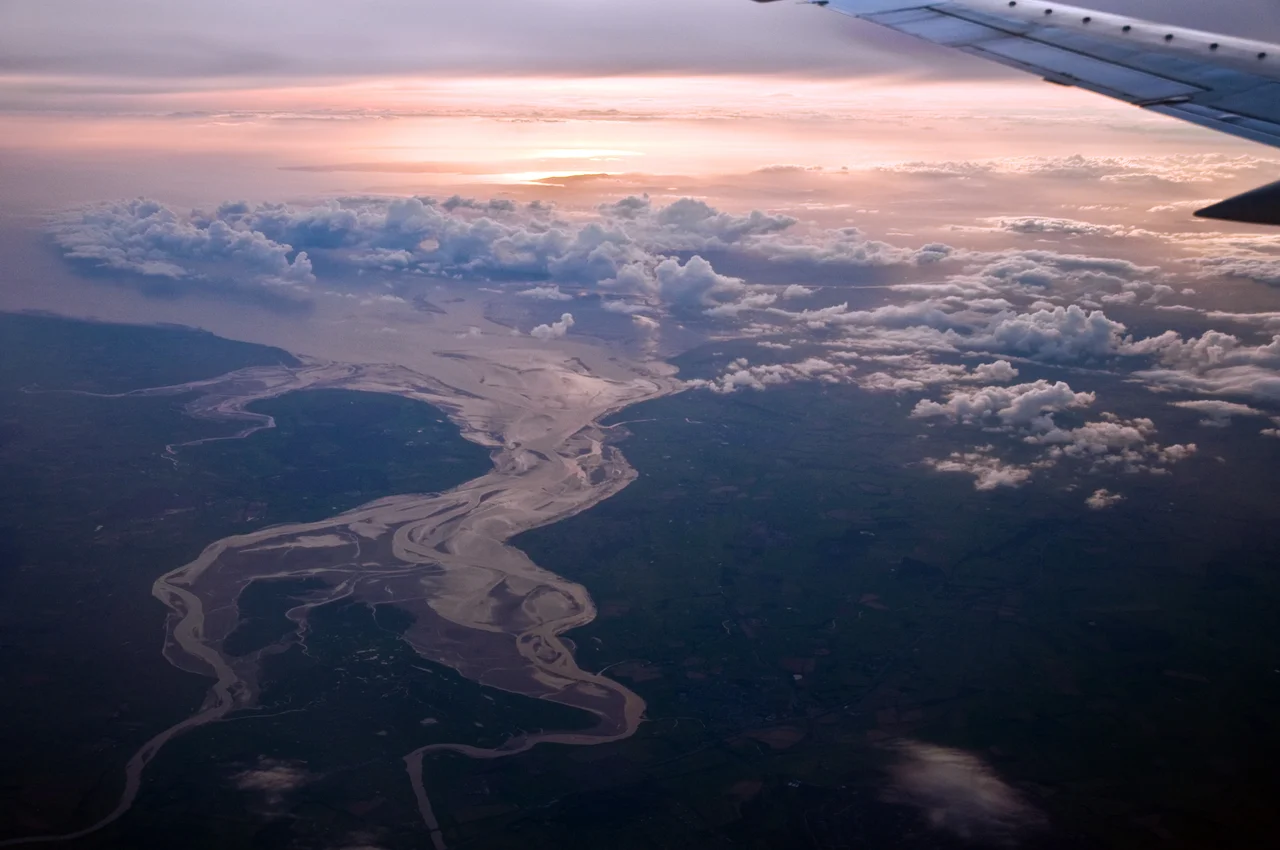
The Solway Firth straddles the Anglo-Scottish border at roughly 54.75N, 3.67W, opening west into the Irish Sea. From the air the inlet's shape is unmistakable: a broad sand-and-mud-flat estuary narrowing east, divided by shifting channels of the Eden and Esk rivers. The Robin Rigg Wind Farm marks the inner firth. The Cumbrian coast runs along the south side from Carlisle to Maryport and Workington; the Galloway coast runs north. Nearest fields are Carlisle Lake District (EGNC) and Dumfries (EGCD). Local weather can change abruptly with funnelled westerlies; sea fog often forms over the mud flats at low water.
Nearby Stories
- St Bees Lifeboat Station 5.5 km away
- Dumfries Museum 7.1 km away
- Caldbeck 7.9 km away
- Cruggleton Castle 8.9 km away
- Wrynose Pass 9.3 km away
- Point of Ayre Lighthouse 13 km away
- Battle of Arkinholm 18 km away
- Battle of Glen Trool 19 km away