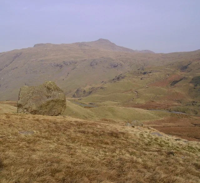

Wrynose Pass
Drop into first gear and lean forward. The tarmac of Wrynose Pass rises ahead at a gradient of one in four, narrows to a single lane, and tilts the world upward in a way that no Lake District map quite prepares you for. Locals still pronounce the name 'Wreynuss' - keeping faith with the 12th-century spelling 'Wrenhalse' - and the meaning is contested. Most place-name scholars settle on the Old Norse for 'stallion's ridge,' though one folk reading suggests 'the horse power needed to climb it.' At 1,289 feet, the summit shows you why both interpretations carry weight.
An Old Road Beneath a New One
Wrynose is not just a steep modern road. It is a Roman road wearing modern tarmac, the original track still visible alongside in stretches. The legions cut this route to link the fort at Galava (Ambleside) with their fort at Glannoventa (Ravenglass) on the Cumbrian coast, and they laid it over the only viable saddle between the Furness Fells and the Bowfell-Crinkle Crags massif. The choice was practical: there was no easier way. Anyone driving the pass today is following an engineering decision made nearly two thousand years ago, and the sense of continuity is sharper here than on any motorway. From the summit, the road tips downward into Wrynose Bottom, where travellers face a fresh choice. South leads to Broughton-in-Furness. West climbs again, over Hardknott Pass and its merciless one-in-three gradient - about thirty-three percent, one of the steepest public roads in England.
Three Counties at One Stone
At the highest point of the pass stands the Three Shire Stone, marking the meeting of Cumberland, Lancashire, and Westmorland - three historic counties whose boundaries converged at exactly this windswept saddle. Before the early 19th century, three separate county stones stood on the same spot, each angled toward its own territory. The current pillar consolidated them. The administrative geography has since been redrawn: the counties were folded into modern Cumbria in 1974, and Cumbria itself was split into two unitary authorities in 2023. But the stone keeps the older lines visible. Travellers who pause beside it are standing in three different places at once, depending on which century they choose.
Fell Foot at the Bottom
At the eastern foot of the pass sits Fell Foot Farm, a 17th-century Grade II listed property now in the care of the National Trust. The contrast tells the story of the road. At the top is exposed scree, a single stone marking lost boundaries, and weather that turns instantly hostile. At the bottom is a farmhouse with thick stone walls and a working life that long pre-dates the asphalt above. Generations of farmers worked these slopes when the pass was a packhorse track, when 'horse power' really did mean a horse, and when the climb above demanded the kind of effort that earned this ridge its various names.
Driving It Today
Wrynose is one of the Lake District's great driving experiences, but it tests vehicles and nerves. Passing places are tight, oncoming traffic is frequent in summer, and cyclists and walkers share the surface. Caravans and large vehicles are discouraged. Yet on a clear morning, with mist still pooling in Little Langdale below and the eastern fells catching the first sun, the climb rewards every gear change. You see why the Romans cut this line, why the Norse named the ridge for a stallion, and why drivers still talk about Wrynose in the same breath as the more famous Hardknott. The two together remain among the most demanding paved roads in England - a pair of pinch points where the landscape never quite agreed to be tamed.
From the Air
Coordinates 54.4128 N, 3.1186 W. Wrynose Pass cuts a clear east-west saddle in the central Lake District fells. Best identified from the air by the parallel valleys of Little Langdale to the east and the Duddon Valley descending southwest, with the road visible as a pale thread crossing between them. Recommended altitude 3,000-4,500 ft AGL. Hardknott Pass lies immediately to the west, identifiable by its steeper switchbacks. Nearest airports: Carlisle Lake District (EGNC), Blackpool (EGNH), and the Walney Island airfield. Lake District weather changes rapidly; orographic cloud forms quickly on Bowfell and Crinkle Crags to the north.
Nearby Stories
- Morecambe Bay 4.1 km away
- Caldbeck 8 km away
- Pendragon Castle 8.1 km away
- Egremont Castle 8.5 km away
- Upper Teesdale 13 km away
- Solway Firth 13 km away
- Malham Cove 21 km away
- Santon Railway Station 70 km away