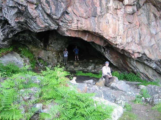

South Rona
Population: one. That is the official figure for South Rona, a long thin island in the Inner Sound between Skye and the Scottish mainland - a place of pink felspar cliffs and old gneiss whose human story has run from Mesolithic hunters to medieval monks to sixteenth-century pirates to a single resident keeping the lights on for the deer and the visiting yachts. Writing in 1549, the Hebridean traveller Dean Monro called it a haven "guyed for fostering of theives, ruggairs, and reivairs." Four and a half centuries later the rough harbour he meant - An Acarsaid Mhor - is still one of the loveliest in the Western Isles, and arguably still the same shape.
Some of the Oldest Rock in Europe
Rona is geologically ancient. Its bones are Lewisian gneiss - Precambrian rock among the oldest in western Europe, formed deep in the crust roughly three billion years ago and dragged to the surface by mountain-building events that finished long before Britain was Britain. Walking the island you can see the gneiss banded grey and pink in long stripes, smoothed and grooved by Ice Age glaciers. The highest point, Meall na h-Acarseid, rises only to 125 metres, which sounds modest until you realize the island itself is only about three kilometres long. Two more hills - Sgath a' Bhannaich and Beinn na h-Iolaire, the hill of the eagle - reach over a hundred metres. The whole place is essentially a knuckled ridge sticking out of the sea, dotted with bog and heath, surrounded by smaller skerries with old Gaelic names: Garbh Eilean, Eilean Seamraig, A' Sgeir Shuas.
The Harbour of the Robbers
On the west side of the island, hidden behind a smaller island called An t-Eilean Garbh, lies An Acarsaid Mhor - the Big Harbour. The travel writer Malcolm Slesser described it as "a delightful little fjord, and superb harbour for small boats. Pink felspar cliffs drop steeply into the water, and small lush woodland lends a touch of luxury." In the sixteenth century, that secrecy made it perfect for piracy. The harbour was then known as Port nan Robairean, port of the robbers. One pirate chief was reputedly Calum Garbh MacLeod, an illegitimate son of the chief of Clan Macleod of Lewis, who established himself at Brochail Castle on neighbouring Raasay in 1518 and used Rona as a raiding base. By the loose convention of the time, the pirates were tolerated by the local clan chiefs on the understanding that they confined their attacks to foreign vessels. Dean Monro, writing in 1549, was less forgiving: he saw the harbour as a place that fostered thieves who preyed on poor people. Both descriptions were probably correct.
Older Than the Pirates
Between 1999 and 2004 a project called Scotland's First Settlers walked the entire coastline of the Inner Sound looking for evidence of Mesolithic habitation. On Rona they found four caves and rock shelters that had been used by people more than seven thousand years ago. The archaeologists concluded that the island was less intensively occupied than other parts of the Inner Sound - probably because of three persistent problems: a shortage of fresh water, thin soil that frustrated farming, and only two safe landing places, the Big Harbour and Dry Harbour. At the south end of the island stand the ruins of a fourteenth-century chapel called An Teampull, probably a monk's cell, with a single gravestone preserved inside its enclosing wall. Whose grave it is, no one now knows.
Modern Era
Clan MacLeod held the island until the middle of the nineteenth century. In 1763 the Laird of Raasay kept a cowhand and 160 cattle on Rona; in 1787 his successor wrote to the Duke of Argyll proposing it as one of the best fishing stations on the west coast. By the late nineteenth century the small permanent population had drifted away. The Ministry of Defence still owns 57.5 hectares at the north end - part of the BUTEC underwater test range, which uses South Rona's quiet waters for noise-ranging submarines. Red deer were reintroduced in 1993 and a fold of Highland cattle from North Uist arrived in 1996. Over three hundred plant species have been recorded. With no sheep to suppress saplings, the native woodland - birch, rowan, hazel - is regenerating for the first time in centuries.
Lights and Visitors
At the northern tip stands the Rona Lighthouse, a Stevenson family design from 1857, automated now and run by the Northern Lighthouse Board. Visiting yachts still use An Acarsaid Mhor as a safe overnight stop in the Inner Sound, where the prevailing southwest gales can turn the surrounding water savage. The handful of restored crofts above the harbour are let as self-catering holiday cottages by the owner, whose single resident keeps the moorings and meets the boats. Rona is the kind of place where you can spend a week and meet no one but the person who owns the island, who will tell you about the eagles on the hill and the otters in the bay and the way the wind comes through the harbour mouth at three in the morning. It is, in its quiet way, still a refuge.
From the Air
South Rona lies at 57.53N, 5.98W in the Inner Sound between the Trotternish peninsula of Skye to the west and the Applecross peninsula to the east. The island runs roughly north-south, about 5 km long. The Rona Lighthouse stands at the northern tip; the safest harbour, An Acarsaid Mhor, opens on the west side roughly midway. The highest point, Meall na h-Acarseid, reaches only 125 m so the island is rarely a hazard but is often hidden in low cloud. The northern 57.5 hectares are part of BUTEC's noise-ranging facility - check NOTAMs for active military air danger areas before crossing the Inner Sound. Nearest ICAO airports: Inverness (EGPE) 95 nm east, Plockton airstrip (EGEC) 20 nm southeast, Stornoway (EGPO) 70 nm northwest. Recommended viewing altitude 2000-3000 ft AGL.
Nearby Stories
- Isle of Ewe 0.7 km away
- Glamaig 1.9 km away
- Torridon 7.2 km away
- Capture of Eilean Donan Castle 7.4 km away
- Tarbert (Harris) 10 km away
- Shiant Islands 15 km away
- Neist Point 18 km away
- German submarine U-722 22 km away