
Spurn
The road ends in water. Twice a day, the high tide reaches across the narrow neck of sand and cuts Spurn from the mainland, turning a peninsula into an island for a few hours before releasing it again. Ptolemy named this place Ocelum Promontorium in the second century. The Vikings landed here. Henry of Bolingbroke stepped ashore in 1399 and went off to dethrone a king. The medieval port of Ravenser Odd thrived here in the 1200s, paying more taxes to the crown than Hull. Then the sea took it, and the village, and the chapel, and everything else that tried to hold ground on this restless ribbon of clay and shell. Spurn is what's left, and even that keeps moving westward at two metres a year.
A Peninsula That Walks
The spit is built from the bones of villages further north. Material eroded from the Holderness cliffs at Flamborough Head travels south along the coast by longshore drift, settling into the sheltered waters at the mouth of the Humber. Marram grass binds it; storms tear it; waves carry sand grain by grain to the tip, lengthening the point and narrowing the neck. Every two hundred and fifty years or so, the sea cuts through, and everything beyond the breach washes away, only to reform further south as a fresh new spit. Dr John Pethick of Hull University proposed a different theory in the twentieth century: that Spurn's southern tip has been anchored on an underwater glacial moraine since the last ice age, while the rest of the spit slides back and forth in slow motion. Either way, the result is the same. Spurn refuses to stand still.
The Drowned Town
Ravenser Odd was a serious place. A medieval port built on a sandy island just inside the Humber mouth, it sent two members to Parliament, held a market and an annual fair, and made Hull look like a backwater. By 1340 the sea was eating its streets. By 1362 the town was gone, dragged grain by grain into the estuary by the great storm now called the Grote Mandrenke. Bodies washed out of the churchyard. Bones rolled up on the beach for centuries afterward. Ravenspurn, slightly further inland, lasted longer, long enough for Henry of Bolingbroke to land there in 1399 and for Edward IV to come ashore on 14 March 1471 returning from exile. Then it too vanished. The Holderness coast has been the fastest-eroding shoreline in Europe for centuries, and what Spurn is made of is, quite literally, the dust of drowned places.
Lights for the Lost
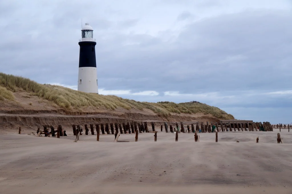
The first beacon went up in 1427, when a hermit named Richard Reedbarrow petitioned Parliament for the right to levy dues on ships entering the Humber so he could maintain a tower at the Point. By the 1670s John Smeaton, the great civil engineer, had built proper coal-fired lighthouses here, replaced and rebuilt many times as the sea kept rearranging the peninsula beneath them. The current black-and-white tower dates from 1895, 128 feet tall, decommissioned in 1985 and restored by the Yorkshire Wildlife Trust in 2016. The older Low Light from 1852 still stands further along the shore, its lantern long ago replaced by a water tank. From the top of the high light on a clear day the entire spit unfolds beneath you: a sand arrow pointing south, lined with the foundations of First World War gun batteries that the sea has been steadily eating since 1918.
The Lifeboat Years
Because the place was too remote to summon a crew from elsewhere, the RNLI built houses for the lifeboatmen and their families at the Point in the 1810s. They lived there permanently, generations of them, in a tiny isolated village at the end of the world. A room in the high lighthouse served as the chapel for keepers, coastguardsmen and fishermen who lived at the Point. The Humber lifeboat station rescued mariners from the Humber approaches for two hundred and thirteen years. Then, in February 2023, an inspection of the launch jetty revealed structural problems no one could afford to fix, and the station was relocated to Grimsby. The cottages stand empty now. The pier is a slowly collapsing memorial to one of the most isolated lifeboat communities in British maritime history.
A Bird Funnel to the World
Every autumn, when easterly winds push Scandinavian migrants out across the North Sea, Spurn becomes one of the most extraordinary birdwatching sites on Earth. Birds funnel down the narrow point and are counted at the Narrows Watchpoint, where three thousand crossing in a morning is normal and fifteen thousand is possible. The Yorkshire Wildlife Trust has owned Spurn since 1960. The bird observatory, run by volunteers, has logged a cliff swallow from North America, a lanceolated warbler from Siberia, a black-browed albatross from the Southern Ocean. The mud flats on the estuary side feed wading birds by the tens of thousands. Ralph Vaughan Williams composed a piece for it in 1926, the second of his Six Studies in English Folk Song, called simply Spurn Point. Even music, it turns out, finds it hard to leave this place alone.
From the Air
Spurn Head extends from approximately 53.59N, 0.14E, projecting south-east into the mouth of the Humber Estuary. Recommended viewing altitude is 2,000 to 3,500 feet AGL to appreciate the full curving arc of the spit and the contrast between sea and estuary mud flats. The black-and-white striped 1895 lighthouse is visible from many miles. Nearest airports are Humberside (EGNJ) approximately 15 nm west and RAF Coningsby (EGXC) further south. Watch for wind farm turbines of Humber Gateway 8 km east. Coastal weather can produce sea mist suddenly.
Nearby Stories
- Westermost Rough Wind Farm 2.5 km away
- Silver Pit 5.4 km away
- Beverley Minster 7.4 km away
- Lincoln Cathedral 13 km away
- 2004 Ingoldmells Bus Crash 14 km away
- Humber Bridge 21 km away
- Holkham National Nature Reserve 33 km away
- SMS Blucher 333 km away