
Stadtallendorf
Three tonnes of TNT came out of the ground here, and it was still capable of exploding. That was in the course of a cleanup that ran from 1991 to 2006, cost the state of Hesse 167 million euros, and removed 154 tonnes of contaminants from the soil and another 697 tonnes from a dump - one of the largest such operations Germany has undertaken, on a site of six square kilometres where people had been living for decades. In parts of the town the chemicals were in residential gardens. What was under Stadtallendorf, and what the town has spent thirty years working out how to live with, is a factory the Allies never found.
Works in the Woods
Until 1960 the place was simply called Allendorf, a name shared with several other Hessian villages and worth nobody's attention. During the Second World War two armaments firms - WASAG, the Westphalian and Anhaltish Explosives company, and DAG - built separate large plants in the forest outside it, and between them they made this one of the biggest munitions production centres in Europe.
The siting was the whole trick. Explosives works want dispersion and cover, and the woods of Upper Hesse provided both. Buildings went up under the canopy, spaced far enough apart that a hit on one would not take the rest. It worked: the complex ran through the entire war without Allied reconnaissance identifying what it was. A town of a few thousand people had one of the continent's great arsenals in its trees, and the aircraft flying over saw forest.
The Women of Münchmühle
A plant that size needs labour, and by the later war years Germany was getting labour by taking it. Around a dozen camps stood in the country around Allendorf, holding German and foreign forced workers and prisoners of war.
One of them was Münchmühle, a subcamp of Buchenwald, and it held about a thousand women - most of them Hungarian Jews, some from Slovakia - from August 1944 until the end of March 1945. They had been taken from their homes that summer and sent on to Allendorf because the factory needed hands, and they were put to work filling munitions. Some of them did not survive the seven months.
The memorial today stands on the ground plan of the camp kitchen and washhouse, marked out in stone. Two masonry pillars hold an iron gate, and the names of the women who were murdered are set into the fence posts. The plaques are in German and in Hebrew.
The Generals in the Stone Camp
When the war ended the Americans arrived and put the site to a different use. Steinlager Allendorf was a rough, improvised prison camp, and through it passed more than two hundred generals and staff officers of the German army, among them Franz Halder, who had run the army general staff for the first half of the war, and Heinz Guderian, the architect of its armoured doctrine. Scientists were held and questioned here too, including Wilhelm Schaefer.
The interrogations were not primarily about guilt. The United States wanted the operational knowledge in these men's heads - how the Wehrmacht had actually fought, and what it had learned fighting the Red Army - at a moment when the Red Army had become the problem. The record survives in the form the exercise took: US Army European Command manuscripts with titles like Questions Asked General Guderian and Answers Given by General Guderian, dated 16 December 1946.
The Town That Grew On Top
Allendorf became Stadtallendorf in 1960 when it was granted city rights, and the new name settled the old confusion with the other Allendorfs. The civic arms kept a memento of it: alongside the striped Lion of Hesse and the six-spoked Wheel of Mainz - the town belonged to the Archbishopric of Mainz until secularisation - there is a gold bear, a reference to the town's earlier byname, Allendorf im Bärenschießen.
About 21,000 people now live in the town's 78 square kilometres, roughly 17,000 of them in the main centre, and about a quarter of that centre's population are foreign nationals. There is a mosque. The factories are still the reason people come: Ferrero makes confectionery here, Fritz Winter casts engine blocks, Hoppe makes locks. The forest that hid the arsenal is now the argument over whether the A49 motorway should be extended through it, the objectors' case resting partly on a population of great crested newts.
Ordinary Weather
Stadtallendorf sits on the Upper Hesse Ridge, on the watershed between the Rhine and the Weser, about 18 kilometres east of Marburg, in gently rolling farm country that gives no hint of any of this. The villages amalgamated into it in the 1970s - Niederklein, Schweinsberg, Erksdorf, Hatzbach, Wolferode - have the churches and the crooked lanes you would expect anywhere in Hesse.
In 2010 the town hosted the fiftieth Hessentag, the state's annual festival, which is about as thoroughly ordinary a distinction as a German town can earn. Margot Käßmann, later a Protestant bishop and one of the more prominent voices in German public life, grew up here. The contaminated ground was signed off as clean in March 2006. The memorial at Münchmühle is a short way out of the centre, and it is open.
From the Air
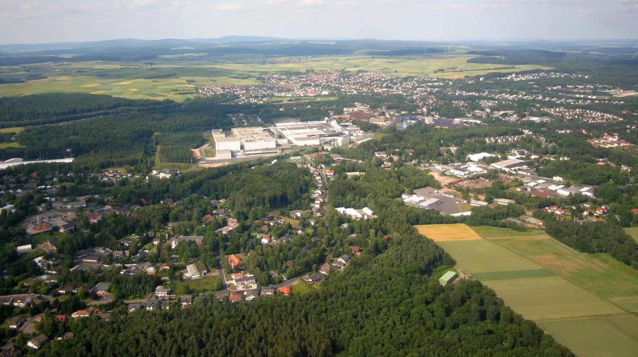
Stadtallendorf lies at 50.833 degrees N, 9.017 degrees E, in northern Hesse about 18 km east of Marburg, on the Upper Hesse Ridge between the Amöneburg Basin to the west and the Schwalm basin to the east. From the air the giveaway is the forest: large blocks of woodland immediately around the town, threaded with the straight service roads of the old works, and industrial plant on the eastern side. The volcanic dome of the Vogelsberg rises to the southeast and the conical hill of Amöneburg with its church on top makes a good visual fix to the west. Nearest major airports are Frankfurt (EDDF), about 100 km southwest, and Kassel (EDVK), roughly 70 km north. Best viewing altitude 2,000 to 4,000 feet. Valley fog is common in the basins on autumn mornings.
Nearby Stories
- Edersee Dam 7.4 km away
- Fulda Gap 14 km away
- The Vertical Earth Kilometer 18 km away
- Dillenburg 20 km away
- Arnsberg Forest Nature Park 28 km away
- Zwingenberg Castle 134 km away
- Marmoutier Abbey 228 km away
- The Defenestration of Prague: The Thrown Men Who Started a Thirty Years' War 353 km away