Arnsberg Forest Nature Park
Stand on the Lörmecke Tower on a clear October morning and the Sauerland reveals itself in layers. Beneath you, around the highest point of the Arnsberg Forest Nature Park, sit unnamed Kuppen - rounded summits of the German Mittelgebirge, three of them in the park's top six and only two of them important enough to have proper names. To the north, fields of the Haarstrang ridge run east and west. The Möhne valley cuts the landscape in two between you and that ridge. On the southern horizon are the higher ridges of the Rothaargebirge. And in the middle of it all, the forest itself - 599 square kilometers of protected ground, around 350 of them tree cover - rises and falls in a slow corduroy of beech, oak, and spruce that has shaped this corner of Westphalia for as long as anyone has been counting.
Between Two Rivers
Geographically, the park is defined by the rivers that bound it. The Möhne traces its northern edge, swelling into the Möhne Reservoir along the way. The Ruhr cuts its southern boundary in a deep wooded valley. Between those two rivers, the Arnsberg Forest Nature Park stretches east-west between six surrounding settlements: Möhnesee at the northwest corner, Rüthen to the northeast, Brilon in the east, Olsberg in the southeast, Meschede in the south, Arnsberg in the southwest. Warstein is the one town actually inside the park's boundary, on the eastern side. The park itself splits into two halves: the Arnsberg Forest in the west and the Warstein Forest in the east. Together, they form a densely wooded slice of the Süder Uplands, part of the broader Rhine Massif that defines the geological backbone of western Germany.
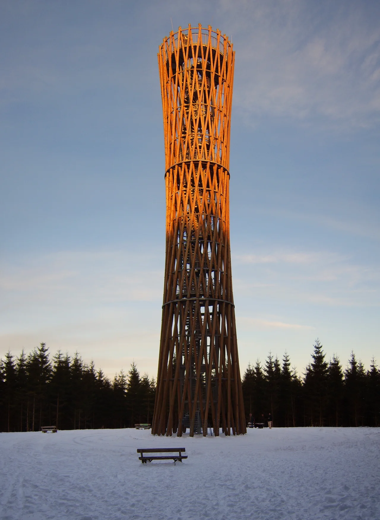
Caves and the Lörmecke Tower
For most visitors, the park's headline attractions sit underground. The Bilstein Cave southwest of Warstein has been opening its show passages to the public for over a century, and it is the kind of cave - with stalactites and stalagmites and curtained limestone draperies - that schoolchildren remember for decades. The Hohler Stein cave near Rüthen-Kallenhardt is smaller but worth the walk. Above ground, the Lörmecke Tower stands on the high ground between Warstein and Eversberg and is the headline viewpoint. There are two more lookout towers worth knowing about: the Küppel Tower near Meschede-Freienohl and the Delecke Bismarck Tower, one of the late nineteenth-century Bismarck monuments, perched north of Möhnesee-Delecke.
A Map of Tributaries
Cartographers love this park for the tangle of small streams that drain it. The Möhne and the Ruhr collect water from a network of named tributaries that read like a poem in old Westphalian. The Biber drops into the Möhne near Rüthen. The Glenne runs into the Möhne northwest of Rüthen-Kallenhardt. The Lörmecke joins the Glenne between Suttrop and Kallenhardt. The Wester reaches the Möhne near Belecke, fed by the Langer Bach and the Wideybach near Warstein. The Heve enters the Möhne at the southern end of the Möhnesee. The Wanne joins the Ruhr near Niedereimer. You will hear these names if you stay long enough; you will walk along them whether you mean to or not. Many of the best hiking routes follow these creek valleys until they find a ridge to climb.
Ridges Without Names
The highest hills of the park are oddly anonymous. The summit of the whole nature park is an unnamed Kuppe, as are the second and third highest points. The fourth, fifth, and sixth - Warsteiner Kopf at 556.9 meters, the Gemeinheitskopf at 551.9 meters, and the Niekopf at 550.4 meters - have names because they have been important to foresters, surveyors, and mapmakers long enough to need one. There is something pleasing about a landscape where the highest ground does not have a name. It suggests that the people who lived here did not bother to single out tops; the forest itself was what mattered, not its measurable peaks. The Nuttlarer Höhe, at 542.2 meters, sits a few meters below in the ranking but is more locally recognizable than the unnamed summits above it.
Walking the Sauerland
The park was set aside in 1960 and has been a working landscape of trails ever since. The Upland Trail, marked as X 13, is the long-distance backbone of the park; the Renn Trail, X 26, weaves through the eastern Warstein Forest. Hundreds of smaller forest paths thread between them. The Sauerland-Waldroute, opened in 2008 and crossing the park as one of its main legs, is the most ambitious long walk in the region. The forest economy still matters - this is one of the more important timber landscapes in North Rhine-Westphalia - but so does the steady stream of walkers, cyclists, and weekenders coming up from the Ruhr cities to spend a day in something that, from the Lörmecke Tower, looks like an unbroken sea of trees.
From the Air
Coordinates 51.3956°N, 8.3461°E, occupying a 599 km² block of the Sauerland uplands east of Arnsberg. The park is clearly defined from the air: the Möhne Reservoir traces its northern boundary, the Ruhr valley its southern, and the forest itself shows as a dark, near-continuous canopy on the rolling hills between, broken by small clearings around Warstein in the east. Best appreciated at 3,500-6,000 ft AGL to take in the whole expanse. The Lörmecke Tower is a useful man-made landmark on the highest ground in the eastern half of the park. Nearest airfields: Meschede-Schüren (EDKM) about 8 km south, Arnsberg-Menden (EDKA) about 25 km west, Paderborn-Lippstadt (EDLP) about 35 km northeast.
Nearby Stories
- Liesborn Abbey 3.7 km away
- Limburg-Hohenlimburg 13 km away
- Nordkirchen Castle 15 km away
- Bilstein Castle (Lennestadt) 18 km away
- Baumwollspinnerei Ermen & Engels 29 km away
- Memleben Abbey 189 km away
- Zwingenberg Castle 193 km away
- Gardelegen Massacre 204 km away