Bilstein Castle (Lennestadt)
Most castles end as ruins, museums, or oligarchs' weekend houses. Bilstein ended as a bunk bed. Since 1927 the steep medieval keep above the village of the same name has served as a Jugendherberge, a youth hostel, and on most school nights of the year there are teenagers asleep in chambers built to house knights and crossbow bolts. The castle sits on green volcanic rock and looks across a tight Sauerland valley. The word Bilstein, according to the philologist Förstemann, means roughly a steeply towering or prominent rock, and the description holds. The castle hill rises like a wedge driven into the landscape, and the stronghold built on it leans into that geology rather than fighting it.
A Spur of Keratophyre
Bilstein is a spur castle, the kind of fortification that depended on terrain instead of size. The promontory on which it stands is an extension of the nearby Rosenberg hill, falling away steeply on three sides. The builders only had to defend one side, the northeast approach back to the parent hill, which meant they could pour their effort into a narrow, dense, very vertical structure. The rock itself is keratophyre, a green volcanic stone that erupted long before there were castles to be built on it. That stone gave both the hill its prominence and the castle its foundation. The whole place is a small lesson in how medieval architects read landscape. They did not flatten the ground. They climbed it.
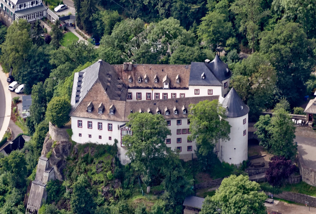
Two Round Towers and a Tunnel
Above ground, the silhouette of Bilstein is dominated by two round towers, each about eight meters in diameter. The Chapel Tower stands at the northwest, the Hohnekamp Tower at the southeast. Below ground, they are connected by a tunnel that runs under the courtyard, a useful piece of military plumbing that allowed defenders to shift between strongpoints unseen. Today a 20th century archway connects the towers above. The northwest wing of the main ward and the central block at the southwest are the original historical fabric. The southeast wing is a 1978 addition, built to expand the hostel's bed count without distorting the silhouette from the valley. A portal terrace called the Soller faces the valley, and a single prominent lime tree grows out of it, an old quiet sentinel above the village below.
Across the Moat by Brick Bridge
Entry to Bilstein crosses a 15-meter-wide moat by a brick bridge. The moat has been partly filled in over the centuries, but it still defines the boundary between the inner castle and the outer bailey. The outer bailey holds three buildings: the gatehouse, a timber-framed house, and a festival hall. Together they form the kind of compact medieval ensemble that survives in pockets across the Sauerland, but rarely intact. Bilstein survives because it kept being used. Castles abandoned in the 17th century tend to be holes in the ground today; Bilstein found new tenants in each century and kept its roofs in repair. The 750-year anniversary book published in 1975 is a reminder that the locals have always considered the castle theirs, not the state's.
Sword, Hunting Place, or Idol
The name itself remains contested. Bilstein and its linguistic cousins, Beilstein, Bielstein, turn up across Germany as field names and place names. The mainstream reading is Forstemann's: a steeply towering or prominent rock. Alternative readings, all of them plausible, connect the name to a hunting place, an idol, or the Old High German word billi meaning sword. None of the four can be proven and all four are evocative. Each suggests a slightly different early use for the hill before there was a castle on it: a strange rock that travelers noticed, a place where local lords hunted, a place where pre-Christian Saxons left offerings, a place where weapons were stored or made. Castles always carry their etymologies as ghosts. Bilstein carries four.
Sleeping in History
Choosing a castle as a hostel was unusual in 1927 and remains unusual today. Other castles in the area went the museum route or the hotel route, manicured into pay-to-enter pieces. Bilstein became a bunk room. Hundreds of thousands of schoolchildren have come through it on class trips since the 1920s, learning the Sauerland by walking out the gate, climbing into the hills, and coming back at dusk to sleep inside a 13th century keep. There is a 1992 book in the local archive called Jugendburg Bilstein 1947 to 1954, Der Weg in die Demokratie, the road to democracy. It tells the postwar story of a generation of West German teenagers being deliberately reintroduced to civic life inside this castle. Few buildings in Germany have done as much quiet political work, in pajamas, after lights out.
From the Air
Bilstein Castle is at 51.0962°N, 8.0193°E in the Olpe district of the Sauerland, in the town of Lennestadt. Cruise the Lenne valley at 3,500 to 5,000 ft and look for the green castle hill rising sharply above the village of Bilstein, just west of the Bigge-Lister reservoirs. Nearest airports: Siegerland (EDGS) about 30 km south, Dortmund (EDLW) about 70 km north. The Rothaargebirge ridges rise to the east.
Nearby Stories
- Festspiele Balver Höhle 2.9 km away
- Schloss Allner 6.1 km away
- Eschbach Dam 15 km away
- Marienstatt Abbey 15 km away
- Ruhr University Bochum 15 km away
- Zwingenberg Castle 159 km away
- Memleben Abbey 215 km away
- Gardelegen Massacre 245 km away