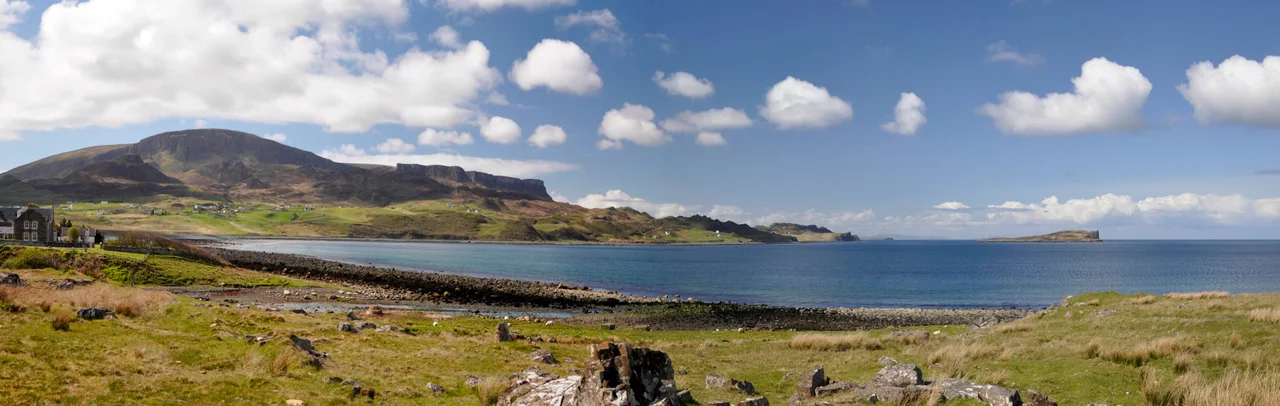

Staffin
At low tide on a stretch of basalt shore called An Corran, dinosaurs left footprints in mud that hardened into stone, and then sat under salt water for one hundred and seventy million years until somebody finally noticed. Eighteen prints are now known, some up to fifty centimetres long, made by a large meat-eating theropod akin to Megalosaurus. The footprints are at Staffin - a small township on the northeast coast of Skye whose Gaelic name, An Taobh Sear, simply means The East Side. In 2010 the community was named Gaelic Community of the Year. A year later, a local crofter was making news for being one of the last people in Scotland still swimming his cattle across an open strait between grazings. Staffin is full of these unlikely pairings.
The Township and the Ridge
Staffin sits on the A855 about seventeen miles north of Portree, halfway up the Trotternish peninsula on Skye's eastern coast. Above it rises the Trotternish Ridge - the longest active landslip in Britain, whose famous fragments include the Quiraing to the north and the Old Man of Storr to the south. What people call "Staffin" is really a parish of twenty-three small townships strung along the coast from south to north: Rigg, Tote, Lealt, Lonfearn, Grealin, Breackry, Culnancnoc, Valtos, Raiseburgh, Ellishadder, Garafad, Clachan, Garros, Marishader, Maligar, Stenscholl, Brogaig, Sartle, Glasphein, Digg, Dunans, Flodigarry and Greap. Each is a handful of houses on a croft road. Together they form one of the most cohesive Gaelic-speaking communities left in Scotland.
Dinosaurs on the Tide
The footprints at An Corran were properly described in 2002 in the Scottish Journal of Geology, in a paper that established their age and identification. They sit on a rippled wave-cut platform that the sea covers most of the time and only exposes at low spring tides, on an igneous bench that has natural cracks often mistaken for prints. Real prints have a distinct three-toed shape, deeper at the front than the back, sized for an animal walking with serious weight on its feet. An Corran is more than dinosaur. It is also a Mesolithic hunter-gatherer site dating to the seventh millennium BC - one of the oldest archaeological sites in Scotland, linked to the rock shelter at Sand, Applecross, across the Inner Sound. The same beach holds the marks of feet that arrived ten thousand years ago and feet that arrived a hundred and seventy million years before that.
A Living Gaelic Place
In the 2001 census, sixty-one per cent of Staffin's population recorded themselves as Gaelic speakers - one of the highest proportions in the country. In September 2010, Comunn na Gaidhlig named Staffin its Gaelic Community of the Year, the first year the prize existed. The same month, Highland Council launched a consultation to convert the local primary school into a Gaelic-medium school. Only five of the thirty pupils had English as their only language; the rest were already bilingual at home. Staffin would become the second school in Scotland to make the switch, after Bun-sgoil Shleite on the southern part of Skye. Language survival in the Highlands is partly economic, partly emotional, partly stubborn. Staffin manages all three.
Crofters and Cattle
Just off the coast lies Staffin Island, a small tidal islet used for grazing. In 2011, Crofter Iain MacDonald was the last person known still to be moving his cattle there in the old way: rowing alongside in a boat, encouraging the animals to swim across the strait in early spring and back again in October. This is the kind of practice that disappears quietly, one retirement at a time. The Staffin Community Trust has been working since 2013 to keep both the working culture and the landscape visible to visitors. With Heritage Lottery funding, the Trust built the Skye Ecomuseum - Druim nan Linntean, the Ridge of Ages - a network of outdoor interpretive sites stretching from Loch Langaig at Flodigarry down to the Old Man of Storr, with new paths, viewing platforms at Lealt Gorge, and signage that explains the geology, the dinosaurs, the clearance ruins, and the Gaelic place names.
The Memorial Above the Bay
The village war memorial stands on a small rise looking out toward Staffin Bay. It was built to remember the local men who died in the Boer War and the two World Wars - a familiar small-village stone in a country full of them. In 2015 the names on it changed. On the seventieth anniversary of the 3 March 1945 crash of a US Army Air Forces B-17G into Beinn Edra, the ridge that rises behind Staffin, the community added the names of all ten American airmen who died there. Most had families far away. None had any connection to Skye until the day they fell on it. Staffin claimed them. The Crofters' Memorial Sùil nam Brà is now being built at nearby Kilt Rock by the same community trust, to honour the families who lived and were cleared from these crofts in earlier centuries. Memory here is something people work at.
From the Air
Staffin lies at 57.63N, 6.21W on the northeast coast of Skye's Trotternish peninsula, about 17 mi / 30 km north of Portree. The village sits at sea level, with the Trotternish ridge rising sharply to the west: the Quiraing summit at 543 m / 1781 ft is 3 nm west-northwest, Beinn Edra at 611 m / 2005 ft is 3 nm west. Staffin Bay opens to the east toward Staffin Island, with the Applecross peninsula and South Rona visible across the Inner Sound. Visual landmarks: Kilt Rock (a sea cliff with vertical basalt columns and a waterfall) is 3 nm south on the coast; An Corran beach (the dinosaur footprint site) is at the head of Staffin Bay. Nearest ICAO airports: Inverness (EGPE) 90 nm east, Stornoway (EGPO) 70 nm northwest, Plockton airstrip (EGEC) 25 nm south. Recommended viewing altitude 3000-4000 ft AGL. Mountain cloud builds rapidly on the ridge.
Nearby Stories
- Isle of Ewe 0.7 km away
- Glamaig 1.9 km away
- Torridon 7.2 km away
- Capture of Eilean Donan Castle 7.4 km away
- Tarbert (Harris) 10 km away
- Shiant Islands 15 km away
- Neist Point 18 km away
- German submarine U-722 22 km away