Strathallan Estate
On 5 February 1840, a Scotsman named Neil McLean paid 816 pounds for two Crown Portions in the Parish of Keelbundoora and named them Strathallan, after a valley in Perthshire he apparently missed. Nearly 200 years later, that name still marks the street grid on the eastern edge of Melbourne's suburb of Macleod - roughly 70 hectares bounded by the Hurstbridge railway line, Wattle Drive, Greensborough Highway, and the Golf Links Estate. Between those two dates lie two bankruptcies, a Royal Commission into corruption, a railway line that was never built as planned, and a land swap enabled by its own act of parliament.
A Scottish Name in a Gum Forest
When McLean arrived, the flatter ground was still dotted with river red gums, Eucalyptus camaldulensis, trees that can live a thousand years and hollow out into homes for possums and parrots. Most of the canopy came down for grazing. McLean's brother Malcolm took over the estate in 1842, but by the late 1850s he had loaded his wife and children aboard a ship back to Scotland, leaving an agent to run the place. The agent did what agents do - leased out parcels to tenant farmers for grazing and dairying, let the land do the talking. For almost half a century, Strathallan was a gentleman's investment, not a home. Then the speculators arrived.
The Bankruptcy of Charles Henry James
In December 1888, at the peak of Melbourne's land boom, Charles Henry James MLC bought Strathallan from the McLean family for 234,000 pounds - an extraordinary sum, nearly 300 times what McLean had paid. James was a member of the Victorian Legislative Council and a major player in the Melbourne property market. Within three years, protracted legal disputes had swallowed him. By 1891 he was bankrupt. The Land Boom of the 1880s had become the Land Bust of the 1890s, and James was one of the most visible casualties. Ownership of the bulk of the property passed to the Commercial Bank of Australia in 1902 - itself a bank that had barely survived the crash, reconstructed after suspending payments during the crisis.
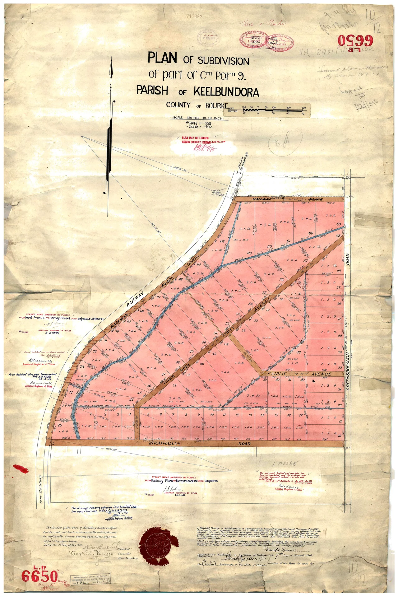
A Railway That Would Not Fit
The Commercial Bank subdivided Strathallan into three sections and on 18 December 1908 sold the northern and central portions to Edith Jessie Macleod for 6,000 pounds. The next day, 19 December 1908, a thin 31.51-hectare strip was sold to the State Government of Victoria for 2,375 pounds - thirty pounds an acre, double what Edith had just paid. The purpose: a branch railway from Hurstbridge line up to the Mont Park asylum. The 1909 Royal Commission into land acquisitions by Sir Thomas Bent examined the deal and found the price excessive. Then came an even stranger discovery. Engineers surveying the route realized the land was too steep for the proposed railway. The government had paid premium prices for a strip of dirt that could not be used. A rescue operation was required.
The Mont Park Land Act of 1910
Parliament passed an entire act to fix the mess. The Mont Park Land Act 1910 authorized a land swap between Edith Macleod and the Crown, trading the unusable steep strip for flatter land that could actually carry a train. The Mont Park branch line was built heading north-west from Macleod station. It served the asylum - a massive psychiatric hospital that dominated the landscape until its closure late in the 20th century - and survived in various forms until the 1960s. The land swap gave Edith the southern portion of what became Part 1 of the Strathallan Estate subdivision: residential lots of about 1,000 square metres each, surveyed in 1910 by Henry Vine Champion and offered for sale the same year.
Selling a Suburb
Part 2 was a different proposition. Surveyed by Donald Fraser, these lots were larger - one or two acres apiece - and went on sale from 1913. Sales were slow. Many buyers simply bundled lots together for later subdivision, and some parcels sat unsold so long that Edith re-surveyed them into smaller blocks and marketed them under new names: the Skye Estate in 1925, the Portree Estate in 1926. The neighborhood grew the way Australian suburbs usually grow - decade by decade, driveway by driveway, the bush cleared for lawns and the lawns eventually swallowed by rose gardens. Macleod Primary School opened, then closed and merged into Macleod College. Winsor Reserve was set aside for the children. An aged-care home arrived on what had once been grazing land. The valley had moved through four identities in under two centuries: contested ground, colonial paddock, speculator's trophy, suburban street.
What the Name Really Marks
One last piece of trivia matters. The nearby Strathalan homestead - spelled without the double-l - is unrelated. The Baptcare Strathalan Aged-Care Homes take their name from that other place, and locals sometimes confuse them. But Strathallan Estate traces directly to Neil McLean's 1840 christening, to a Scottish glen transplanted onto a ridge in Wurundjeri country, and to every subsequent transaction, scandal, and surveyor's peg that worked that name deeper into the map. Today it reads as ordinary suburb: schools, driveways, the railway line still running on the western flank. The drama is in the paperwork.
From the Air
Strathallan Estate sits in Melbourne's northeastern suburb of Macleod, approximately 15 km northeast of the Melbourne CBD. Melbourne Airport (YMML / MEL) lies about 22 km to the northwest; Essendon Airport (YMEN / MEB) is closer at about 15 km west. Recommended viewing altitude 2,000-5,000 feet for the suburban grid pattern. Look for the Hurstbridge railway line curving along the western edge of the estate and the Greensborough Highway to the east. The Yarra River valley lies a few kilometers south. Coordinates given for this record place it near 7.72 degrees S, 145.08 degrees E - a point in Papua New Guinea's highlands that does not match the Melbourne location described; pilots should treat the suburb location as authoritative.
Nearby Stories
- Gulf of Papua 29 km away
- Goaribari Island 33 km away
- Purari River 113 km away
- Bulolo 123 km away
- Battle of Wau 133 km away
- MV Mamutu 140 km away
- Goroka 150 km away
- Naval Base Port Moresby 241 km away