Purari River
In 1930, two Australian brothers and a single companion walked into a valley that no outsider had ever mapped, followed a river for weeks through gorges no European had descended, and emerged at the Coral Sea carrying proof that an entire civilization lived in the New Guinea highlands. The river Michael Leahy and Michael Dwyer rode out is called the Purari - 630 kilometers of muddy, brown, surging water that rises in the Kandep District of Enga Province and empties into the Gulf of Papua. It drains 33,670 square kilometers of some of the wettest country on earth. It is the third-largest river in Papua New Guinea. It carries, on average, between 3,000 and 4,000 cubic meters of water per second past its delta.
A River Made of Mountains
The Purari does not start as a river so much as assemble itself from others. The Kaugel comes down from near Mount Giluwe. The Erave drains south from Mendi country. The Lai, the Tua, the Pio all join at different points along the descent. The thing we call the Purari really begins south of Mount Karimui, where the Tua and Pio merge and plunge into a spectacular gorge. From that gorge the river breaks out onto lowland and flattens into delta country before the Gulf of Papua takes it. Mount Wilhelm, the high point of the whole catchment at 4,510 meters, feeds meltwater and monsoon runoff into tributaries that feed the main stem. Upstream, the water runs clear over rocks. Downstream, it is thick brown, the color of milk chocolate, laden with silt stripped from the mountains by rain that falls two to eight meters a year depending on where you stand.
The Leahys Head In
Mick Leahy was a gold prospector. Australian, ambitious, the kind of man who kept going when sensible men turned back. In 1930 he and his brother-in-arms Mick Dwyer set out to cross unexplored country in search of gold, following the headwaters of the Purari upstream from the coast and then working back down. The expedition charted the river system itself, but that was incidental. The real news came from the highlands they crossed: valleys packed with villages, terraced gardens, sophisticated irrigation. Accurate estimates suggested hundreds of thousands of people lived in country outsiders had assumed was uninhabited. The Leahys triggered a wave of official patrols through the 1930s. The highlands had been hidden behind the Purari's gorges and the mountain walls for as long as the world had been mapping itself. The river was the way in.
The Scale of the Sediment
Rivers are usually understood as water. The Purari is more honestly understood as sediment. Each year, roughly 105 cubic kilometers of water leave this delta. Inside that water ride 88.6 million cubic meters of mud, sand, and gravel - mountain matter in transit. The Gulf of Papua's floor is being paved, kilometer by kilometer, with ground-up highlands. That sediment, along with what the Fly and Kikori rivers contribute, creates one of the great deltaic complexes on Earth. Banks shift. Channels braid and re-braid. What looks on a map like a permanent river mouth is really a temporary arrangement between flood cycles. Dugout canoes can work the lower river from Wabo to the sea; upstream, the water is too white and too fast, except for people who grew up on it.
The Wabo Dam That Waits
For decades, planners have looked at the Purari and seen voltage. The river's altitude drop and its reliable monster discharge make it one of the more obvious hydroelectric candidates in the tropics. The Wabo Dam has been studied, debated, and deferred for half a century. In 2010, the governments of Papua New Guinea and Queensland signed a Memorandum of Cooperation with PNG Energy Developments Ltd and Origin Energy to progress the project. The idea is to dam the river and export power to Australia via submarine cable. Every engineering study shows it is technically feasible. Every environmental and social review shows it would transform the valley and displace communities whose ancestors have lived along this river since long before the concept of a kilowatt existed. The dam remains unbuilt. The river remains the third-largest in Papua New Guinea, running brown to the sea.
Jungle and Canoe
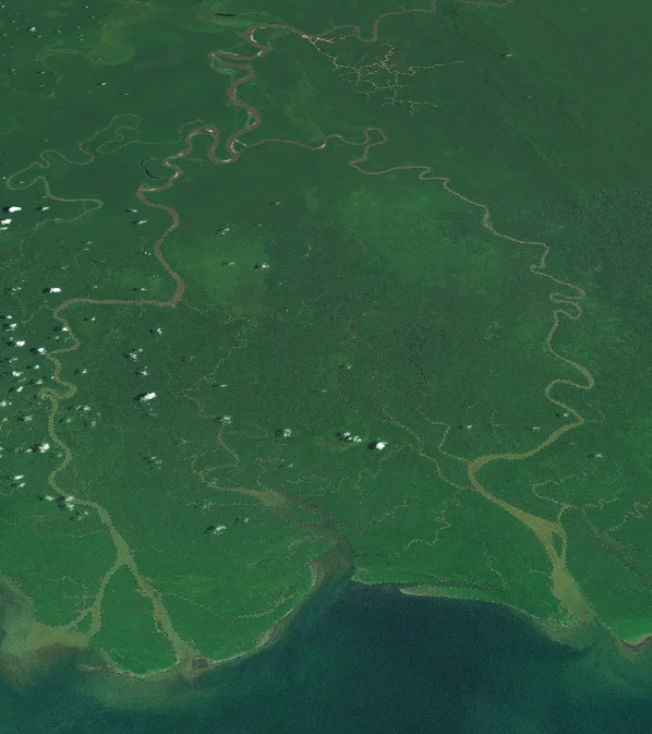
Population along the Purari is sparse. Most of the basin sits under heavy tropical jungle - high rainfall forest that supports enormous bird populations, cuscus, tree kangaroos, and birds of paradise at altitude. Human settlements are mostly subsistence villages strung along the riverbanks, garden plots cut into the forest edge. From Wabo downstream, dugout canoes appear on the water, log-hulled boats carved from single trees. Populations thicken as the river nears the delta, where villages can support themselves on fish and sago palm and the occasional catch of wild boar. The long, quiet middle of the river belongs to the forest, the floods, and the few clans whose territories run along its banks. Flown over from altitude, it reads as a brown thread winding through solid green, bending back on itself in lazy meanders where the highlands finally give up their weight and let the river slow.
From the Air
The Purari drains through central Papua New Guinea, with the mainstem identifiable from altitude by its muddy brown color against the green of the rainforest. Coordinates near 6.4 degrees S, 144.25 degrees E mark a point on the lower river. Recommended viewing altitude 10,000-20,000 feet. Closest airports are Mendi (AYMN) upstream and Kerema (AYKM) on the coast near the delta. Port Moresby's Jacksons International (AYPY / POM) is about 250 km southeast. The delta meets the Gulf of Papua around 8 degrees S. Weather: afternoon thunderstorms routine; mornings offer the clearest views of the river corridor.
Nearby Stories
- Highlands (Papua New Guinea) 13 km away
- Diocese of Mendi 14 km away
- Mendi 33 km away
- Mount Wilhelm 44 km away
- Goroka 70 km away
- Western Papua New Guinea 115 km away
- Strathallan Estate 119 km away
- Goaribari Island 122 km away