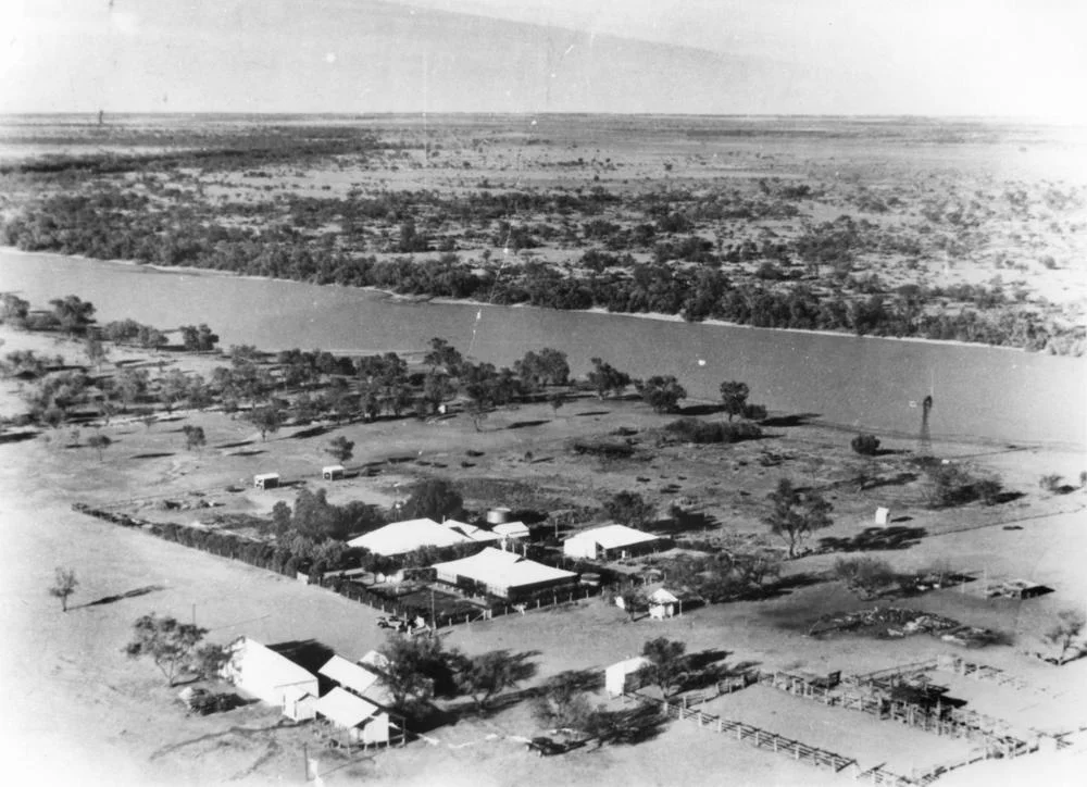

Tanbar Station
In March 1949, floodwater closed in around Tanbar Station and would not leave. For more than a month the homestead and its neighbours were islands in a brown inland sea, the roads gone, the only lifeline aircraft dropping food from above. That story tells you almost everything about this place. Tanbar is a pastoral lease in the Channel Country of south-western Queensland, set along the channels of Cooper Creek about 87 kilometres south-west of Windorah, and its entire fortune rises and falls with water that arrives from somewhere far over the horizon. It is a property measured not in paddocks but in thousands of square kilometres.
A Long Line of Owners
Tanbar's history is a procession of pastoralists chasing good seasons. The run was taken up some time before 1884 by John Costello, who sold it almost at once to the partnership of Armitage and Gillately. In 1886 the country enjoyed a fine year, six inches of rain falling in under a month and every waterhole brimming. John Henderson held it in 1888; B. Richardson added Tanbar to nearby Abbottsford Station, also on the Cooper, in 1903; and by 1907 the Christian brothers were in possession. In 1911 they sold the station, then carrying 10,000 cattle, to the Rocklands Pastoral Company for 30,000 pounds. By 1931 Tanbar sprawled across some 3,000 square miles, still under Rocklands, with Keeroongooloo Station as a neighbour in a land where neighbours lay a long way apart.
A Speck on the Cooper
Place Tanbar on a map and the scale of the isolation comes into focus. It lies in the Shire of Barcoo, about 87 kilometres south-west of Windorah, the nearest town of any size, and some 240 kilometres north-east of Innamincka, away across the South Australian line. Cooper Creek does not so much border the property as run through its heart, and that single fact governs everything. The Cooper is one of the three great rivers of the Channel Country, draining the Lake Eyre Basin, and its waters here are not a steady stream but a slow, episodic flood that may take weeks to arrive from rain that fell far to the north. Around the homestead, the same surveyed corner of the border that gives Haddon Corner its name sits within the wider Tanbar holding, a reminder of how thinly people are scattered across this immense country.
Living by the Flood
On the Cooper, a station's stocking rate is a wager on rain that may not fall for years. In a good year the floodplains green up and the country fattens cattle as well as anywhere in Australia. In a poor one, the herd has to be cut back hard. In 2002, deep in drought, Tanbar carried just 5,000 head, far below the roughly 24,000 it could run when the seasons were kind. The 1949 flood that forced aircraft to parachute supplies was the same coin's other face: too little water threatens the cattle, too much cuts off the people. Either way, life here is shaped by a river that spends most of its time as a string of waterholes and only occasionally becomes a flood that fills the channels from bank to bank.
An Operation at Continental Scale
Today Tanbar is vast even by outback standards, a holding of about 8,300 square kilometres, or roughly 1.02 million hectares, strung along the Cooper Creek channels. For years it belonged to the Western Grazing Company, which had acquired it from the Stanbroke Pastoral Company in 2004. Then, in 2016, Tanbar changed hands again, bought by Paraway Pastoral Company in a deal reported at around 130 million dollars that also took in Rocklands Station to the north-west, with tens of thousands of cattle included in the sale. Under Paraway it runs as a large-scale growing and finishing operation, turning the feast-and-famine bounty of Cooper Creek into beef, the latest chapter in nearly a century and a half of pastoralists betting on the same uncertain country.
From the Air
Tanbar Station lies at about 25.84 degrees S, 141.92 degrees E in the Channel Country of south-western Queensland, roughly 87 km south-west of Windorah and around 240 km north-east of Innamincka. The Cooper Creek channels thread through the property and are its most striking feature from the air: a braided maze of watercourses and waterholes, dry and dull for much of the year, but spreading into broad sheets of floodwater after big rains upstream. Windorah (YWDH) offers the nearest sealed strip, with Birdsville (YBDV) and Quilpie (YQLP) further afield; large stations like this typically maintain their own private airstrips for mustering and supply. This is remote, sparsely populated country with no nearby controlled airspace and minimal night lighting, so carry generous fuel reserves and plan navigation carefully. Visibility is usually very good, though heat haze and dust may reduce it in summer, and recent flooding can render unsealed strips unusable.
Nearby Stories
- Channel Country 34 km away
- Canterbury, Queensland 35 km away
- Windorah Solar Farm 39 km away
- Lake Yamma Yamma 41 km away
- Tenham (meteorite) 61 km away
- Arrabury 79 km away
- Eromanga Refinery 103 km away
- Burke and Wills Plant Camp 158 km away