Taroko Gorge
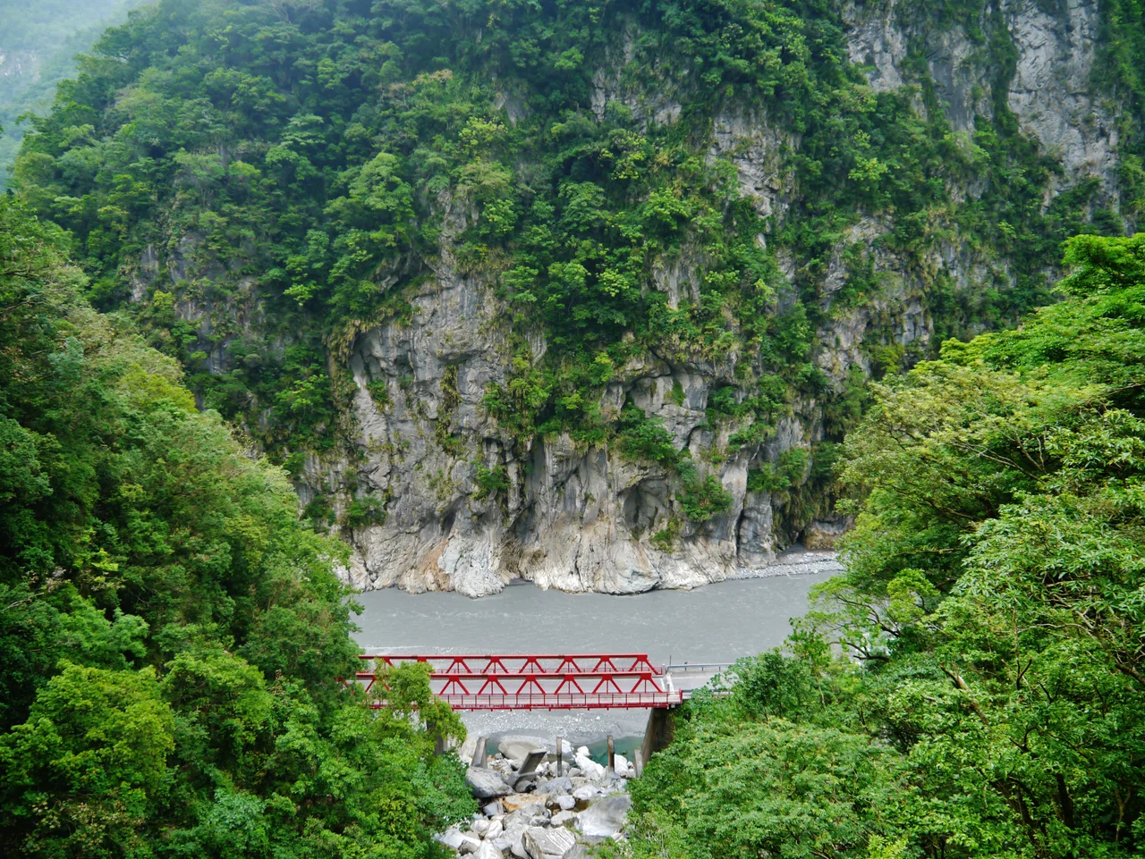
The walls close in until they are barely a dozen meters apart, rising 300 meters straight up on both sides. Below, the Liwu River runs blue-green over boulders, the color of dissolved minerals in glacially cold water. This is Taroko Gorge, and the word "taroko" itself tells you what to expect -- it means "magnificent and splendid" in the language of the Truku, the indigenous people who have lived in these mountains for centuries. The 19-kilometer-long canyon near Taiwan's east coast is, alongside Bhedaghat Gorge in India and Trigrad Gorge in Bulgaria, one of only three river-carved gorges in the world cut entirely through pure marble. Seventy million years of tectonic uplift and relentless water have produced something that geology textbooks describe in clinical terms but that the human eye receives as overwhelming.
Marble Born from the Sea
The marble of Taroko began as calcium carbonate deposits on the ocean floor roughly 230 million years ago. Over vast spans of time, pressure and heat transformed those deposits into limestone, and then into marble. When the Philippine Sea Plate collided with the Eurasian Plate about four million years ago, the resulting uplift -- the Penglai Orogeny -- pushed these marble formations skyward, creating the Central Mountain Range that runs the length of Taiwan. The Liwu River did the rest, carving through the rising marble with the combined force of subtropical rainfall and relentless gravity. The result is a canyon where the walls are composed of rock that is both hard and beautiful: swirled white and grey marble, polished by water, shot through with veins of quartz. The gorge continues to deepen even now. Taiwan's tectonic plates push the mountains up a few millimeters each year, and the river cuts them back down, an arms race between geology and hydrology that has been running for millions of years.
From Sea Level to the Sky
The most astonishing thing about Taroko is the scale of its vertical relief. In roughly 60 kilometers, the landscape rises from rugged sea-level coastal cliffs to peaks exceeding 3,400 meters -- some of the tallest in Taiwan. In a single afternoon, a visitor can travel from subtropical forested canyons to high-elevation subalpine coniferous forests. The park shelters 144 species of birds, ten percent of which are found only in Taiwan. Over 30 large mammal species inhabit the forests, including deer, boar, and Formosan black bear. Monkeys inhabit the quieter trails. Some 251 species of butterflies have been documented, along with 32 species of reptiles and 18 species of fish, though researchers suspect these numbers represent only a fraction of the actual biodiversity in terrain too rugged to survey completely.
Walking Through the Walls
Taroko's trail system ranges from gentle riverside walks to heart-pumping cliff-edge routes that require permits and nerves. The Shakadang Trail follows a tributary river through turquoise pools and water-sculpted rock. The Tunnel of Nine Turns threads through hand-carved passages in the marble cliff face, with windows opening onto dizzying drops to the river below. The Zhuilu Old Trail traverses a cliff face 500 meters above the gorge floor on a path originally built by the Japanese during the colonial era. Hard hats are provided at several trailheads -- for good reason. Rockfall is a constant risk, especially after rain or seismic activity, and several trails are frequently closed for safety. The 2024 Hualien earthquake caused catastrophic landslides throughout the gorge, and as of 2025 much of the park remains closed. When it is open, Taroko rewards the prepared visitor with scenery that has no equivalent anywhere else on the island.
The Truku Homeland
Before the gorge was a national park, it was home. The Truku people, formally recognized by the Taiwanese government as a distinct indigenous group in 2004, migrated to this region from the upper Zhuoshui River, crossing Mount Qilai -- which they call Klbiyun -- to reach the Liwu River valley. When the park was established on November 28, 1986, it marked a turning point for Taiwan's environmental movement, demonstrating that the government was willing to protect natural resources after four decades of relentless economic development. The park was originally designated as a national park under Japanese colonial rule on December 12, 1937, abolished in 1945 when the Republic of China took control, and not re-established for another 41 years. In 2002, it was named a potential World Heritage Site. The Truku continue to live within the park boundaries, their presence a reminder that Taroko is not just a geological wonder but an inhabited landscape with a human story as layered as its marble walls.
From the Air
Coordinates: 24.177°N, 121.520°E, on Taiwan's east coast in Hualien County. The gorge is dramatically visible from altitude as a deep, narrow cut through the Central Mountain Range, with the Liwu River running through it. The Qingshui Cliffs along the coast just north of the gorge are among the most striking coastal features in East Asia. Highway 8 (Central Cross-Island Highway) threads through the gorge. Nearest airports: Hualien (RCYU), approximately 20 km south. Peaks in the park area exceed 3,400 m. The Eternal Spring Shrine, built into the cliff face, may be visible from lower altitudes.
Nearby Stories
- Sun Moon Lake Wen Wu Temple 4.2 km away
- Taiping Mountain Forest Railway 9.9 km away
- Miaoli Ceramics Museum 13 km away
- Nuomi Bridge 13 km away
- 2024 Hualien Earthquake 14 km away
- Sinking of MV Sewol 1153 km away
- Yellow Sea 1208 km away
- Twin Forts of Romblon 1260 km away