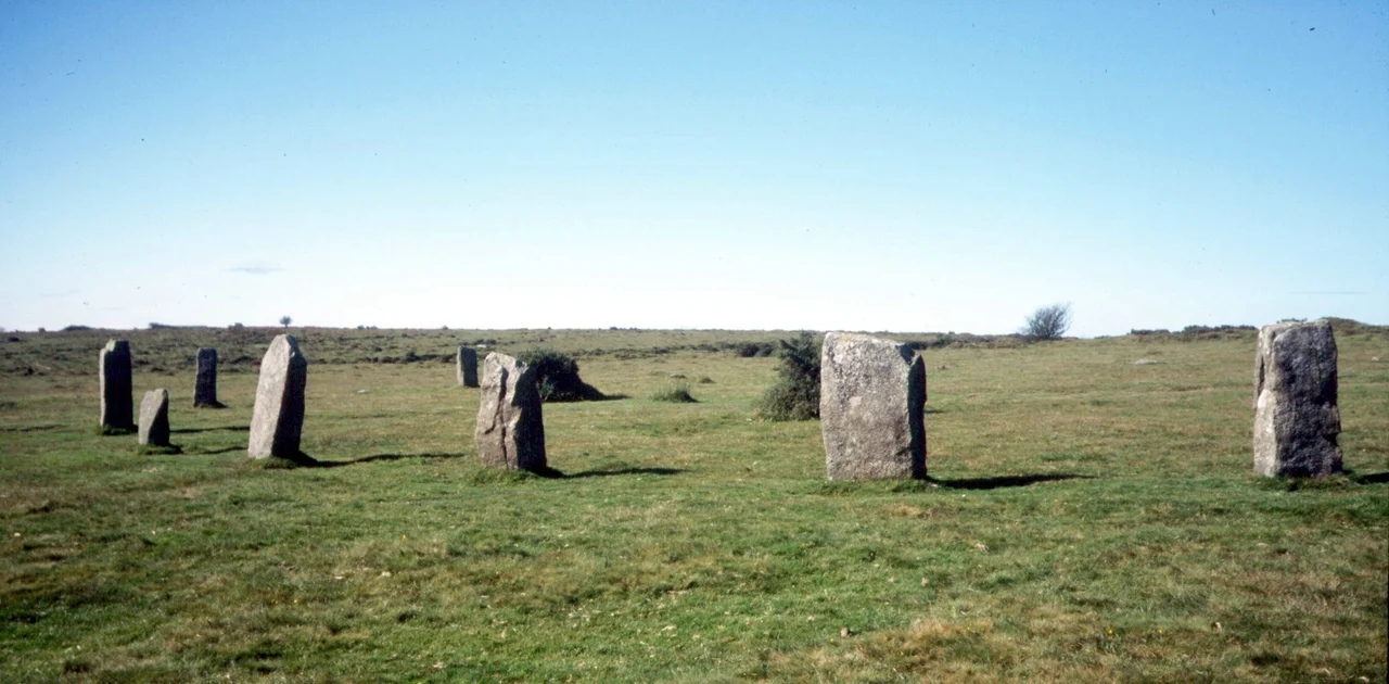

The Hurlers (stone circles)
The men were hurling. It was Sunday. According to the Cornish legend that gave these three stone circles their name, that was enough: God turned the players into granite where they stood, and two musicians who had been piping nearby suffered the same petrification a few yards to the west. They have been standing on the eastern flank of Bodmin Moor for somewhere between three and four thousand years, and the legend, told and retold around hearths in Minions, was a way of explaining the unexplainable - why anyone, in the deep past, had bothered to drag these stones into precise rings on a windswept upland half a mile from anywhere.
Three Rings in a Line
The Hurlers lie south-southwest to north-northeast in a deliberate alignment that suggests their builders cared about how the three monuments related to each other. The middle circle is the largest, 42 metres across and slightly elliptical, flanked by two true circles measuring 35 and 33 metres. The southern circle has fared worst. Nine of its stones survive, of which only two still stand upright; the rest lie partly buried in the turf, sinking back into the moor that supports them. Just west of the rings, two further uprights known as the Pipers complete the legend's cast. They look like outliers until you notice they are paired and that the line they describe points back across the circles toward the rising sun on particular days of the year. Whether the builders of around 1500 to 2000 BC had astronomy or ceremony or both in mind is a question the stones do not answer.
The Antiquaries Arrive
The historian John Norden was the first scholar known to have walked among the Hurlers, around 1584, sketching them and trying to make sense of what he saw. William Camden mentioned them in his *Britannia* of 1586, and from then on the Hurlers entered the slow stream of antiquarian curiosity that fed eventually into archaeology. In the 1930s Ralegh Radford excavated the site and partly restored the two northern circles, re-erecting fallen stones and placing markers where missing stones had once stood. His excavation reports went unpublished in his lifetime, and recent re-evaluation by Jacky Nowakowski of the Cornwall Archaeological Unit and John Gould of English Heritage has begun to recover what Radford found. A 2009 survey suggested there may be a fourth circle and two stone rows beneath the moor's thin soil, awaiting confirmation.
Vega, Arcturus, and the Borderline Case
In 1967 the Scottish engineer Alexander Thom, who had spent decades arguing that Britain's stone circles were calibrated astronomical instruments, turned his theodolite on the Hurlers. He proposed two solar alignments and four stellar alignments involving the bright stars Vega and Arcturus, tabulated for dates between 2100 and 1500 BC. Thom himself called the alignments at the Hurlers 'borderline cases,' which was unusually cautious for him. Modern archaeoastronomy has generally moved away from his more confident claims, but the question Thom raised still hovers over the site. Why three circles in a line? Why this particular spot on the moor, in clear view of the Cheesewring tor to the north and Caradon Hill to the east? The builders chose carefully. They chose, and then they left.
Countless Stones
Another Cornish belief insists that the stones of the Hurlers cannot be counted. Try, and you will arrive at a different total each time, or so generations of moorland walkers have claimed. The legend belongs to a wider British tradition - Stonehenge and Avebury share variants - and may simply reflect how irregular weathered stones confuse the eye. Or it may be older than that, a folk acknowledgement that some things resist the tidiness of arithmetic. Nearby on the moor stand Rillaton Barrow, where a gold cup was found in 1837 that is now on loan to the British Museum from the Royal Collection, and Trethevy Quoit, a Neolithic entrance grave whose enormous capstone still rests on its uprights. The Hurlers belong to a whole prehistoric landscape, not just to themselves.
The Heritage Trust Years
In 1999, members of a pressure group called the Revived Cornish Stannary Parliament removed English Heritage signs from the Hurlers and several other Cornish monuments, in a protest against what they saw as English cultural overreach. The episode ended with the trio bound over by the courts, but it shifted policy. Care of the Hurlers, along with Dupath Well, Tregiffian Burial Chamber, St Breock Downs Monolith, King Doniert's Stone, Trethevy Quoit and Carn Euny, was transferred to the Cornwall Heritage Trust on behalf of English Heritage. The Hurlers were scheduled as a monument in 1981, with the Pipers added to the protected area in 1994. Today you walk to them across open moor from the village of Minions, the highest village in Cornwall. The Devon singer Seth Lakeman wrote a song about them in 2008. The stones, as they have for millennia, simply stand.
From the Air
Coordinates 50.5163°N, 4.4582°W, on the southern edge of Bodmin Moor near the village of Minions, about 4 miles (6 km) north of Liskeard. Best viewed at 1,500-3,000 ft above ground level for the alignment of the three circles to be visible against the moorland. The Cheesewring granite tor stands about 1 km north, Caradon Hill transmitter to the east. Nearest airfields: Bodmin EGLA grass strip 15 nm west, Plymouth area further east. Moorland weather changes quickly; haze often masks the stones from higher altitudes.
Nearby Stories
- Padstow 1.1 km away
- Hope Cove Lifeboat Station 3.5 km away
- Holsworthy 3.6 km away
- The Great Thunderstorm 6 km away
- Prehistoric Cornwall 9.2 km away
- Eddystone Lighthouse 14 km away
- Tiverton Castle 29 km away
- HMHS Glenart Castle 36 km away