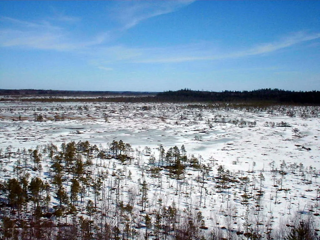

Torronsuo National Park
The middle of Torronsuo is higher than its edges. That is the strangest thing about the place, and it takes a moment to accept: a wetland that has grown into a low dome, so that walking out from the forest margin means walking gently uphill onto a plain of moss with nothing solid under it. No stream feeds this bog. No spring, no lake, no groundwater. Everything Torronsuo is made of arrived as rain and snow, was captured by sphagnum moss, and then failed to rot. Bogs like this are called ombrotrophic - cloud-fed - and the result at Torronsuo is a peat layer that reaches twelve metres in places, among the deepest ever measured in Finland.
The Arithmetic of Not Decaying
Peat is a bookkeeping error in the carbon cycle. Sphagnum moss grows, dies, and settles into water so acidic and so starved of oxygen that the bacteria which would normally finish the job simply cannot work. Each year's growth presses down on the last. Nothing is subtracted. Finland's bogs began forming after the last ice sheet withdrew from this landscape, and Torronsuo has been quietly adding to itself ever since, layer on waterlogged layer, until the accumulation lifted its own centre clear of the surrounding land. Twelve metres of peat is not a depth so much as an archive - every millimetre of it laid down by moss that was alive on a particular Finnish summer and never given the chance to disappear.
Northern Birds That Never Went North
Roughly a hundred bird species nest on the bog, which for an open, treeless, apparently empty landscape is a remarkable figure. What makes the list unusual is not its length but its geography. Many of the birds and flying insects at Torronsuo belong to the north - species you would expect in Lapland rather than in Kanta-Häme, a couple of hours' drive from Helsinki. A raised bog is functionally a piece of subarctic Finland stranded in the south, cold, wet, nutrient-poor and open to the sky, and the animals adapted to those conditions found it and stayed. The park is valued for its butterflies for exactly the same reason. Torronsuo is a Ramsar site, listed under the international convention on wetlands of global importance.
Walking on Something That Floats
You cross it on duckboards. Routes of 1.5, 8.5 and 10 kilometres run out from the Kiljamo parking area, and a separate 5.3-kilometre circuit loops the neighbouring Piippurinsuo bog. The planks are the only reason the interior is reachable at all, and they change how the place feels: the surface flexes under your weight, and the horizon is unbroken in every direction, which is a thing southern Finland almost never offers. At Kiljamo a 17-metre tower lifts you above the moss for the view that makes sense of the dome. A second tower at Idänpää was built in 1997 by volunteers on private ground. That same year a forest fire burned through nearby Tammela woodland, and a piece of the burnt ground was afterwards taken into the park - a rare case of a national park growing by accident.
Protected Twice Over
Torronsuo was already a protected area before it became a national park in 1990, which matters more than the paperwork suggests. Across the twentieth century Finland drained an enormous share of its peatlands for forestry and agriculture, ditch by ditch, and a bog that survives in near-natural condition this far south is a survivor rather than a default. The park now draws more than fifty thousand visitors a year, most of them walking the boardwalks in the low golden light of late summer, when the cloudberries ripen and the moss turns a colour somewhere between rust and wine. Research published in 1996 described Torronsuo as Finland's largest raised bog massif - several bog units that have grown together into one continuous system. Standing on the tower at Kiljamo, that is exactly what it looks like: not a wetland with edges, but a country of its own.
From the Air
Torronsuo lies at 60.734 N, 23.618 E in Tammela, Kanta-Häme, roughly 10 km south of Forssa and about 100 km northwest of Helsinki. It is one of the easiest landmarks to identify from the air in southern Finland: an unbroken pale, treeless oval set into otherwise continuous dark conifer forest and farmland, with no lake or river inside it. In autumn the moss surface reddens noticeably against the surrounding green. The Kiljamo tower and parking area sit on the northern edge. Recommended viewing altitude 2,000-4,000 ft for the dome's shape to read; the low relief flattens out above about 6,000 ft. Nearest airfield is the light-aviation strip at Forssa (Haudankorva district); nearest commercial airports are Helsinki-Vantaa (EFHK), Turku (EFTU) and Tampere-Pirkkala (EFTP). Morning mist pools over the bog surface in late summer and autumn and can obscure it entirely until mid-morning.
Nearby Stories
- Salo 10 km away
- The Artillery Museum of Finland 11 km away
- Nummi Church 12 km away
- Urjala 14 km away
- Sarka (museum) 16 km away
- Hakoinen Castle 24 km away
- Huittinen 34 km away
- National Museum of Finland 49 km away