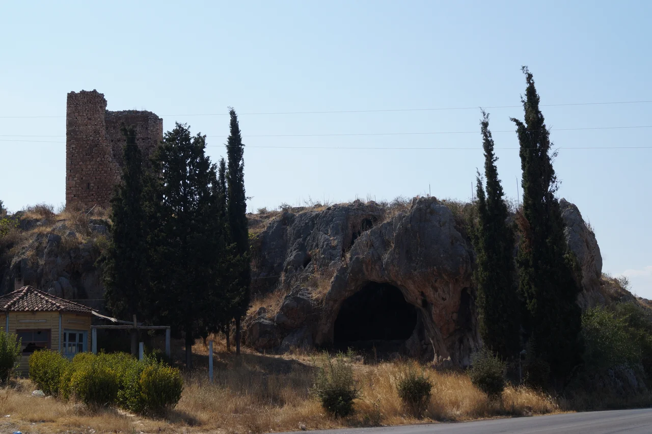

Tower of Aliartos
There is a cliff south of the road between Thebes and Livadeia where the ground drops away sharply and the view opens across what was, for most of recorded history, a shimmering inland sea. Lake Copais is gone now — drained in the nineteenth century into productive farmland — but the cliff remains, and on it stands a medieval tower that has watched over this crossing point for perhaps seven or eight centuries. The Tower of Aliartos, also known as the Tower of Moulki, is not large. At roughly eight metres square and fifteen metres tall, it would fit inside many a modern building. But it is almost complete, it is built with evident care, and its position on that cliff edge above the vanished lake gives it a presence out of proportion to its size.
Stone on Stone
The tower was built from hewn stone, mostly undressed but laid in reasonably regular courses. At the corners — the structurally critical quoins — the builders used dressed stone, and among those corner blocks are pieces of spolia: architectural fragments taken from the acropolis of ancient Haliartos, which stood nearby. The courses diminish in size as the tower rises, a technique that reduces weight on the lower structure. The result is a building that tapers slightly as it climbs, giving it a subtle taper that reads as intentional rather than accidental. At the base, the walls are 1.65 metres thick; the interior chamber on the ground floor measures about 3.5 metres on each side, covered by a semicircular arch. The tower had four floors in total.
How You Got Inside
The tower's original entrance was not at ground level. The opening you see at the base today is a modern addition. The real gate was on the second floor, on the southern face of the building — a defensible position that would have required a removable wooden staircase or ladder to reach. The evidence for that staircase is still visible: a line of putlog holes, the square sockets left when horizontal timber beams are removed, runs across the southern wall at the height where the stair would have been affixed. The two middle floors each had eight window slits, two per wall, providing both ventilation and a wide field of view over the surrounding terrain. The top floor was vaulted, reinforced by a double arch — that vault has since collapsed.
Frankish Boeotia
Who built the tower, and exactly when, is not certain. It has sometimes been described as part of a late Byzantine defensive system along the Boeotic Cephissus river and Lake Copais. But the consensus among scholars leans toward a different origin: the tower is most likely of Frankish construction, built during the period when Boeotia was controlled by the Duchy of Athens, the Crusader state that ruled much of central and southern Greece from the early thirteenth to the mid-fourteenth century. The Franks who settled in Greece after the Fourth Crusade built extensively — castles, towers, and fortified farmhouses — and the Tower of Aliartos fits the scale and character of those smaller Frankish military buildings. Whoever raised it, the location was chosen to command the road and the crossing point where the ancient lake's southern shore narrowed toward the passage between Thebes and Livadeia.
Cliff, Caves, and the Vanished Lake
At the base of the cliff below the tower, a number of caves open in the rock face. Their origins are uncertain — they may be medieval, possibly connected to the tower's use, or they may be more recent, the product of lime-burning operations that hollowed out the soft limestone. The cliff itself was formed by the ancient shoreline of Lake Copais, which once covered the broad flat basin between Orchomenus, Coronea, and Haliartos. The lake was one of the most distinctive geographical features of ancient Boeotia, drained in part by underground channels — some of them Mycenaean engineering works — and fully reclaimed only in the late nineteenth century. Standing on the cliff today, with the tower above and farmfields below where water once reflected sky, it is possible to read the landscape as a kind of geological document: ancient lake, ancient city, medieval tower, modern fields, layered in roughly the order they arrived.
From the Air
The Tower of Aliartos stands at approximately 38.368°N, 23.120°E, on a clifftop near the modern village of Aliartos in Boeotia, about 90 kilometres northwest of Athens International (LGAV). Flying northwest from Athens, the former Lake Copais basin is visible as unusually flat agricultural land between the ridgelines — a telltale sign of the drained lake bed. The tower itself is small from altitude but the cliff on which it sits is a distinct feature along the southern edge of the basin. The modern road from Thebes to Livadeia runs close below; the ruins of ancient Haliartos lie in the hills above.
Nearby Stories
- Aulis (ancient Greece) 4.3 km away
- Pleistos 4.6 km away
- Doris (Greece) 5.9 km away
- Corinth Rail Disaster 6.9 km away
- Daphni Monastery 16 km away
- Loutraki 19 km away
- Saint George Monastery, Aidipsos 23 km away
- Skopelos 51 km away