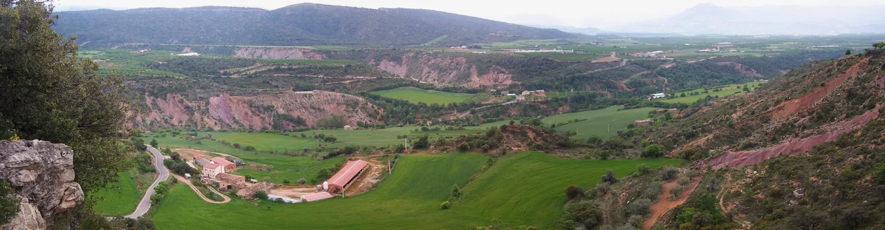

Tremp Formation
In the red and gray rock around the town of Tremp, you can read the last 300,000 years of the dinosaurs. This band of Pyrenean stone, the Tremp Formation, was laid down across the very end of the Cretaceous and into the age that followed, which means it contains something rare: the Cretaceous-Paleogene boundary, the exact geological line at which the age of dinosaurs ended. Layer by layer, the formation preserves the animals that lived here right up to that moment, more than a thousand dinosaur bones, whole nests of eggs, and trackways pressed into ancient mud. It is one of only a handful of places in Europe where the closing of an entire world is written plainly in the ground.
The Last 300,000 Years
What makes the Tremp Formation extraordinary is not just its fossils but its timing. Hadrosaur footprints have been found here in the rock of the final 300,000 years of the Cretaceous, the last stretch before the great extinction, making these among the youngest dinosaur traces in this part of Europe. The boundary itself is registered at several localities in the basin, at Coll de Nargo, Isona, and Fontllonga, where geologists have pinned it down using paleomagnetism and sharp shifts in carbon and oxygen isotopes. Curiously, the telltale iridium layer that marks the boundary at famous sites like Gubbio in Italy and Caravaca in Spain has never been found here. That absence is part of why the formation ranks among the best-studied stratigraphic units on the continent.
A Dinosaur Nursery in Stone
Above all, this is a landscape of eggs. At Basturs, dinosaur nests spread across some 6,000 square meters, the subcircular eggs roughly 20 centimeters across and clustered in groups of four to seven, many preserved exactly where they were laid. The great clutches, some holding more than two dozen eggs, belonged to titanosaurs, the last of the giant long-necked sauropods. Too vast and heavy to warm their eggs with their own bodies, these animals relied on the heat of the ground itself, burying their clutches much as certain modern birds still do. Around the nests moved a whole community: duck-billed hadrosaurs, whose tracks are the most abundant of all, along with crocodiles, turtles including the newly named Polysternon isonae, lizards, amphibians, fish, and small mammals. Paleontologists have compared this assemblage to Hateg in Romania, another late-Cretaceous island world famous for its dinosaurs, and the Tremp Formation, together with the neighboring Aren Formation, ranks as the richest source of dinosaur fossils anywhere in the Pyrenees, with more than a thousand bone fragments recovered at Basturs alone.
A Coast at the End of an Age
The dinosaurs of Tremp did not live in a jungle but on a shifting coast. The rock records a continental-to-marine world of estuaries, deltas, river channels, and marshes, where thick clays were laid down across coastal plains and swampy margins turned to beds of lignite. To the south, the Montsec was already rising as a low rise on the horizon. As the Cretaceous sea drew back, wide braided rivers spread sand across the plain, and it was in these muds that the last dinosaurs left their eggs, bones, and footprints. Some marks once read as sauropod tracks at the Ermita La Posa were later reinterpreted as the feeding pits of rays combing the intertidal flats, a reminder of how much the sea was still part of this vanished shoreline.
Reading the Rock
The formation was defined and named in 1968 by the geologist Mey and his colleagues, after the Pre-Pyrenean town of Tremp that gives the whole basin its name. Since then it has drawn universities and researchers from across Europe, and its finds are displayed close to where they were dug, in the natural science museums of Tremp and nearby Isona, where educational programs explain the geology and the lost creatures to visitors. In 2016 the Tremp Basin was put forward to become a UNESCO Global Geopark, and UNESCO approved the bid on April 17, 2018, designating it the Conca de Tremp-Montsec Global Geopark, part of a country that already holds more of these designations than anywhere on Earth except China. The rock itself is a jumble of environments turned to stone, its sandstones, shales, marls, limestones, lignites, and gypsum beds each recording a different corner of that ancient coast. Here, in a quiet corner of Catalonia, the deep past is not hidden away in a distant museum but exposed in the hills, open to anyone willing to look.
From the Air
The Tremp Formation is exposed across the Tremp basin near 42.110 N, 1.073 E, in the comarca of Pallars Jussa, in the Pre-Pyrenees of northern Lleida province. From 5,000-8,000 feet the basin reads as a broad lowland ringed by ridges, with the Montsec range walling it to the south and the higher Pyrenees rising to the north; the reddish Garumnian beds and the Segre and Noguera Pallaresa river cuts are the key landmarks. Nearest airport is Lleida-Alguaire (LEDA) to the south; Reus (LERS) and Barcelona-El Prat (LEBL) lie further southeast. Surrounding terrain is high, so allow clearance and expect mountain weather.
Nearby Stories
- Patum de Berga 7.3 km away
- Battle of Almenar (1082) 12 km away
- Cave of Saint Ignatius 14 km away
- Cervera 19 km away
- Battle of Graus 32 km away
- Aiguestortes i Estany de Sant Maurici National Park 33 km away
- Abbey of Saint-Martin-du-Canigou 56 km away
- Ordesa y Monte Perdido National Park 63 km away