Três Picos State Park
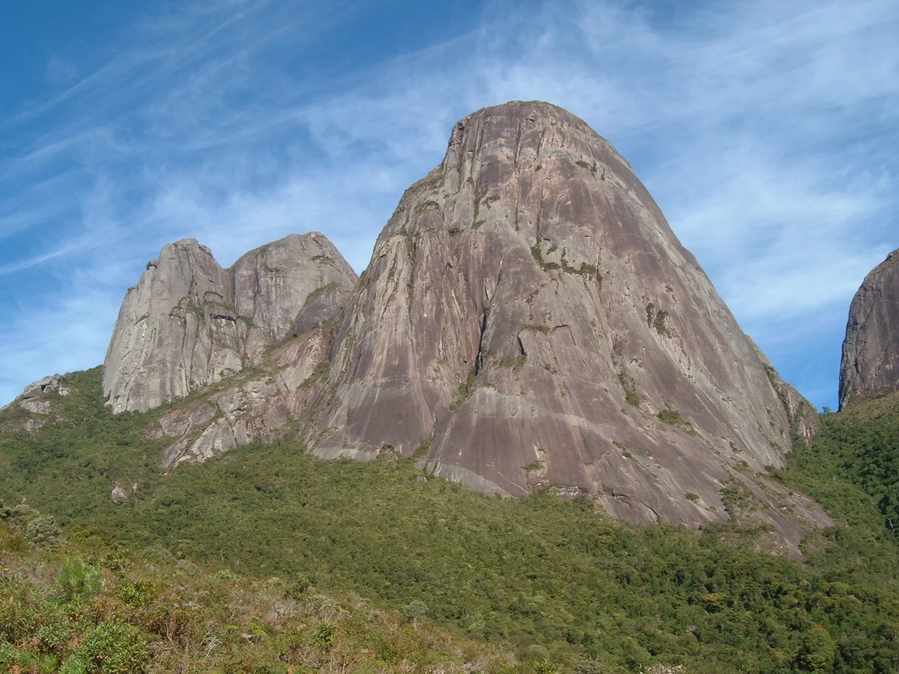
The Three Peaks rise to 2,316 meters. Climbers have mapped more than 100 routes up them, of wildly varying difficulty - some a scramble, some requiring ropes and bolts and several days. The peaks anchor the center of the Serra do Mar, the coastal range that runs the length of southeastern Brazil, and they give this state park its name. Três Picos, the largest state park in Rio de Janeiro, protects 65,000 hectares of what the rainforest of this coast used to be everywhere.
The Richest Biodiversity in the State
Altitude creates abundance here. The park ranges from 100 meters above sea level to 2,316 at the highest peak - a vertical climb through half a dozen ecological zones. Dense sub-montane rainforest covers the lower slopes. Cloud forest wraps the middle elevations in permanent mist, dripping onto bromeliads and mosses and tree ferns. Alpine meadows claim the highest ridges, their vegetation stunted by wind and cold. Hawks soar the thermals. Pumas - called cougar in the scientific literature, suçuarana in Portuguese - range through the park in the kind of numbers only possible where prey is abundant and human pressure is low. Arthropods, fish, amphibians, reptiles: the inventories keep finding new species. Among Brazilian conservation scientists, Três Picos is a priority.
A Park Five Municipalities Share
The boundaries cross five municipalities. Cachoeiras de Macacu holds the largest share - about 48.92% at creation, and roughly two-thirds by 2016 after boundary adjustments. Teresópolis contains 20.08%. Nova Friburgo contributes 19.26%, Silva Jardim 7.53%, Guapimirim 4.21%. The division matters for governance - five different town halls with different priorities, five different road-maintenance budgets, five different sets of local politics. That Cachoeiras de Macacu has become the dominant gateway is partly geography and partly a concentration of waterfalls. Dozens of them tumble through the ravines of that municipality, drawing hikers and canyoneers into the dripping shade of what remains one of the best-preserved stretches of Atlantic Forest in all of Brazil.
Created in 2002, Grown Since
State decree 31.343, signed on 5 June 2002, created Três Picos at 46,350 hectares. The objectives were clear: preserve the remnants of Atlantic Forest in this section of the Serra do Mar; recover degraded areas; protect rare, endemic, and endangered species; connect with the central Atlantic Forest corridor; maintain the springs and water bodies that supply the coastal cities below. In 2006 the park joined the Central Rio de Janeiro Atlantic Forest Mosaic, linking it to a network of protected areas that functions as a single biological corridor. State decree 41.990 in August 2009 added 12,441 hectares, bringing the total to 58,790. In 2013 the boundaries were redefined by state law 6.573 - absorbing the Paraíso Ecological Station and portions of nearby protection areas - and by 2016 the park covered 65,113 hectares.
The Three Peaks
The peaks themselves sit in Nova Friburgo municipality, their granite faces weathered from millions of years of exposure. Climbers come from across Brazil and abroad to work the routes. Some ascents require bivouac on narrow ledges, hundreds of meters above the cloud forest canopy. Others are day climbs for experienced scramblers. All offer views across the Serra do Mar toward the coast and inland toward the Paraíba do Sul valley. The peaks are sacred to climbers in the way specific mountains always become sacred - a piece of stone that rewards discipline and sometimes punishes carelessness. Deaths have occurred. Rescues are difficult. The rangers of Três Picos take the mountain as seriously as it deserves.
A Forest That Still Rains
The Atlantic Forest once covered Brazil's entire coastal strip, from Rio Grande do Norte in the north to Rio Grande do Sul in the south. Less than 15% remains today, fragmented and isolated. Três Picos holds one of the largest continuous patches left. The forest here still does what forests do - intercepts rain, feeds springs, cools the slopes, shelters species that elsewhere have nowhere to retreat. The springs that rise in the park supply the cities below. When coastal Rio de Janeiro drinks, it drinks from the clouds that catch on the shoulders of Três Picos and return in streams to the valleys.
Visible From the Sky
From altitude the park reads as a dark irregular shape draped across the central Serra do Mar, the three peaks marking its high ground and the surrounding cloud forest darkening the slopes below. The Baía de Guanabara glitters to the south; the Paraíba do Sul valley opens inland to the north. Dedo de Deus, the famous Teresópolis spire just west of the park, is the easiest landmark for orientation - once you find that granite needle, Três Picos is the extended darkness of forest to its east, reaching all the way to the coastal plain.
From the Air
Located at 22.42°S, 42.61°W in the Serra do Mar, 80 km northeast of Rio de Janeiro. Recommended viewing altitude 7,000-12,000 ft above the peaks. Visual landmarks: the Três Picos summits reach 2,316 m; Dedo de Deus spire in neighboring Teresópolis is a useful navigation reference; the Atlantic coast lies south, the Paraíba do Sul valley north. Nearest airports: Rio de Janeiro-Galeão (SBGL) 90 km south, Jacarepaguá (SBJR) 100 km southwest. Weather: frequent cloud cover on peaks; dry-season mornings (May-September) offer clearest views.
Nearby Stories
- Miguel Pereira 24 km away
- Macaé 41 km away
- Desengano State Park 43 km away
- Juiz de Fora 46 km away
- Rio de Janeiro 54 km away
- Leopoldina, Minas Gerais 69 km away
- Basilica of Our Lady of Aparecida 205 km away
- Grytviken 3546 km away