Trigana Air Flight 267
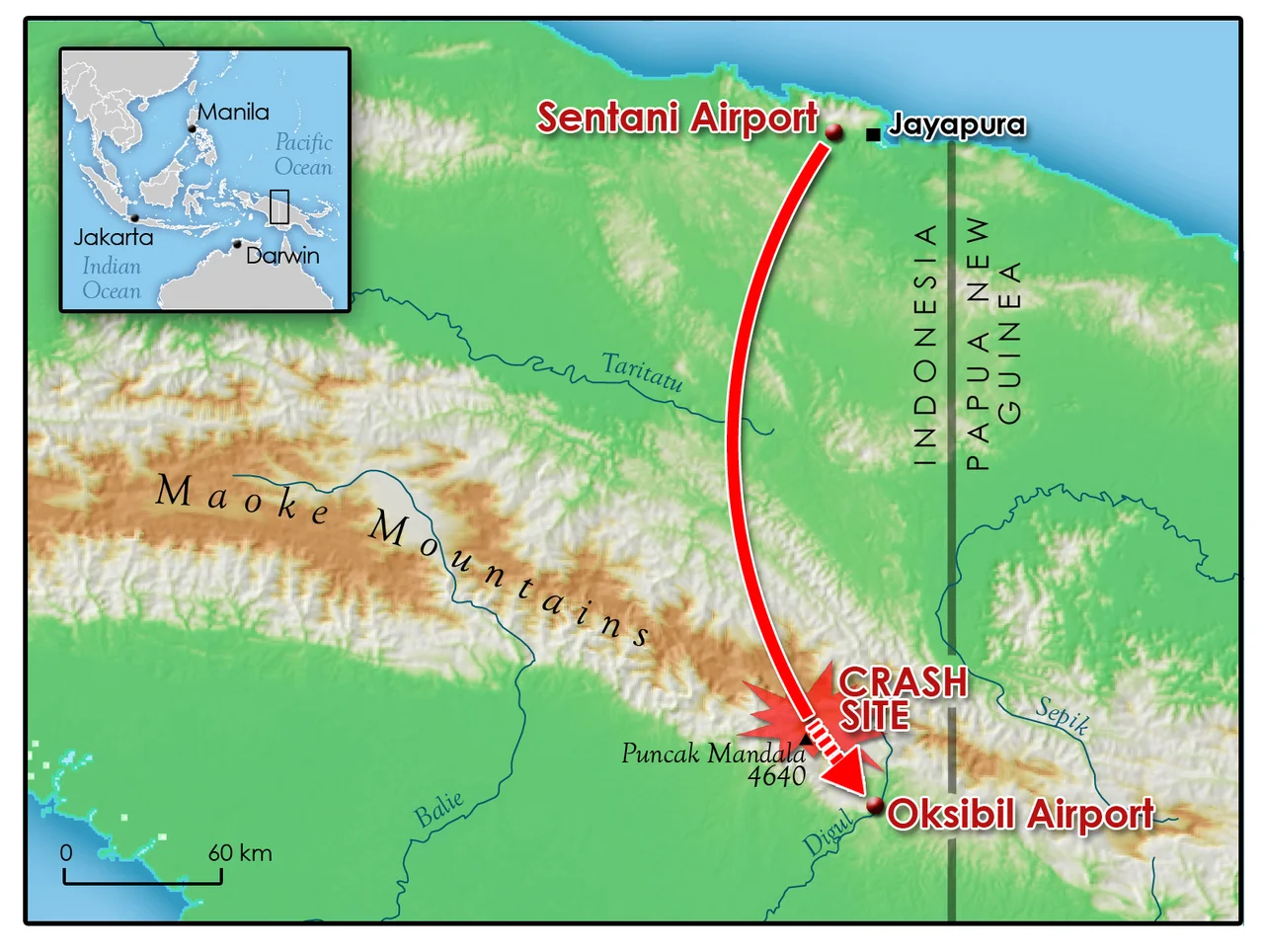
The weather was good. That was the strange thing. When Trigana Air Flight 267 lifted off from Sentani Airport in Jayapura at 14:22 on 16 August 2015, the afternoon was clear across most of Papua, the visibility was serviceable, and another crew landing at the destination had just radioed back to say the conditions were fine. The ATR 42-300 turboprop held 49 passengers and 5 crew. Among them were four postal workers carrying 6.5 billion rupiah in cash to distribute under President Joko Widodo's anti-poverty program, government officials flying in for the 70th anniversary of Indonesian independence, three children, and two infants. Thirty-three minutes into what should have been a 42-minute flight, the aircraft disappeared.
The Country It Was Flying Into
Oksibil sits in the Bintang Mountains of Papua's far eastern highlands, in a country so remote that BASARNAS, Indonesia's search and rescue agency, would later say the terrain around the crash site had never been previously explored on foot. Ridges rise to above 8,000 feet; valleys are narrow; the weather can shift in minutes from clear to opaque fog that, in pilots' words, "came out of nowhere." The approach into Oksibil's short runway is one of the more demanding in Indonesian regional flying, with few navigational aids. Most airports in Papua relied, in 2015, on visual flight rules and pilot familiarity rather than instrument procedures. The Transportation Ministry itself later acknowledged that some of the country's navigation equipment dated to the 1950s.
Ten Minutes from Touchdown
At about 14:55, on what should have been the final descent into Oksibil, the ATR 42 lost contact with air traffic control. No distress call was made. The crew gave no indication of trouble. At 15:30, BASARNAS launched a search aircraft, but closing weather grounded the effort within hours. When a search resumed the following day, local residents in the Okbape district of Pegunungan Bintang Regency approached police with an account: they had seen the aircraft strike the side of Tangok Mountain. The wreckage was confirmed shortly afterward. The impact had fragmented the aircraft into small pieces. There was, the recovery teams later said, no chance any passenger or crew member could have survived.
A Recovery on Foot
The altitude was too high and the terrain too steep for rescue helicopters to lift wreckage or bodies directly. BASARNAS deployed 250 personnel to Oksibil, and recovery teams had to reach the wreckage either in a three-day walk from the nearest access road or a six-hour drive followed by a steep climb. Three Disaster Victim Identification teams from the Indonesian National Police were deployed to work on identifying the dead - some bodies were intact but burned; others had been so fragmented by the impact that identification required DNA, dental records, and forensic samples sent by families. By the evening of 19 August, 17 bodies had been carried down. The flight data recorder was found on 20 August, four days after the crash.
The Right Turn That Shouldn't Have Happened
The flight data recorder had been malfunctioning for more than a year. Trigana had kept the aircraft in service anyway. With the FDR inoperative, investigators from the Indonesian National Transportation Safety Committee had to reconstruct the flight path from cockpit voice recordings and Google Earth. What they found was that Flight 267 had deviated to the right of the approach corridor, into a section of terrain rising to 8,000 feet. The weather in the valley was good, but localized fog - those sudden patches that Papuan pilots know well - had formed in the mountains. The aircraft descended while inside cloud, with the ridges invisible. The NTSC's conclusion was clear: the crash was controlled flight into terrain. The crew flew a serviceable aircraft, under minimal pressure, into a mountainside they could not see.
The Mess Afterward
Trigana's passenger manifest, released to the public, turned out to be from a different flight. The chairman of Sentani Airport was fired. Sixteen airport staff were investigated; two Trigana employees were taken into custody. Transport Minister Ignasius Jonan called the situation "a big mess." Trigana eventually paid 1.25 billion rupiah in compensation for each person killed, with an additional 100 million rupiah per person from the insurer Jasa Raharja. The airline's own safety record entered the public conversation: fourteen accidents between 1992 and 2016, eleven of them hull losses. Indonesian aviation overall sat "below the global average" in ICAO safety audits, with at least one fatal crash every year since 2010. Flight 267 became, with 54 dead, the deadliest ATR 42 accident in history. It also became another number in a statistical pattern that Indonesian regulators have been trying to change ever since.
From the Air
Crash site near 4.82S, 140.50E, in the Bintang Mountains of Highland Papua. Oksibil Airport (WAJO/OKL) sits at approximately 4,300ft MSL in a narrow valley ringed by 8,000-10,000ft peaks. Sentani Airport (WAJJ/DJJ) in Jayapura is the origin for most Bintang-bound flights. The approach into Oksibil is VFR-only and weather-critical - localized orographic fog develops unpredictably even in otherwise clear conditions. Navigation aids are limited; pilot familiarity with the route is essential. Cruise at FL200+ for a safe eastern Papua overview; direct approach procedures require current local briefings.
Nearby Stories
- Ok Tedi Environmental Disaster 22 km away
- Ok Tedi Mine 51 km away
- Battle of Bobdubi 76 km away
- 1981 Irian Jaya Earthquake 82 km away
- Baliem Valley Campaign 108 km away
- Baliem River 122 km away
- 2016 Indonesian Air Force C-130 Crash 172 km away
- Aitape 221 km away