Tungurahua
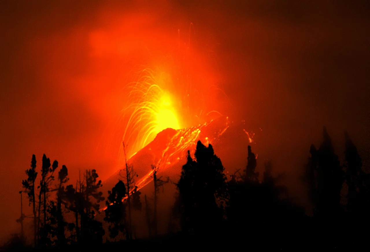
Mama Tungurahua, the Kichwa called her, and the name carries its own warning. The volcano's name breaks down from the Quichua tunguri, throat, and rahua, fire: the Throat of Fire. At 5,023 meters in the Cordillera Oriental of the Ecuadorian Andes, 140 kilometers south of Quito, she rises above the thermal springs town of Banos de Agua Santa, whose name translates roughly to Baths of Holy Water. Nobody who watched her erupt on August 16, 2006 would have disputed the fire half of the nickname. The ash plume climbed 10 kilometers into the sky. Pyroclastic flows poured down the slopes. Five people died. The hamlet of Chacauco was buried. Banos, just 8 kilometers to the north, watched as ash and tephra spread southwest across an area of 740 square kilometers.
Three Mountains in One Place
What stands today is the third volcanic edifice on this site. Tungurahua I collapsed at the end of the Late Pleistocene, around 30,000 years ago. Its successor, Tungurahua II, built a caldera which then collapsed roughly 3,000 years ago, give or take 90 years. The current cone, Tungurahua III, grew inside that caldera. The pattern, build, collapse, rebuild, is what stratovolcanoes do. Each eruptive cycle deposits layers of andesite and dacite, the two rock types Tungurahua consistently produces. Ash layers preserved in the lakes of El Cajas National Park record major prehistoric eruptions roughly 3,034, 2,027, 1,557, and 733 years before present, each dated with a wide margin of uncertainty. The mountain has been doing this for a long time.
A Century of Named Eruptions
Over the last 1,300 years, Tungurahua has entered an active phase every 80 to 100 years. The major ones in historical memory are 1773, 1886, and 1916-1918. Each event produced strong explosions, pyroclastic flows, and sometimes lava flows from the summit crater. The 1886 eruption was violent enough to be recorded in detail, with witnesses documenting the ash plumes and the evacuations. Between cycles, Tungurahua goes quiet, her summit capped with snow and, in the twentieth century, a small summit glacier. That glacier is gone now. The rising temperature of the volcanic edifice after 1999 melted it away.
The Phase That Would Not End
On August 19, 1999, after a long quiescent period, Tungurahua began erupting again, and she did not really stop until 2017. Eighteen years of sustained activity, with episodes ranging from constant low-level emissions to catastrophic eruptions. The first serious event came in October 1999, when heavy ashfall forced the temporary evacuation of more than 25,000 people from Banos and the surrounding countryside. Activity persisted at medium intensity until May 2006, when the volcano escalated sharply. July 14, 2006 produced a violent eruption. August 16, 2006 produced the most destructive explosion of the entire cycle, generating pyroclastic flows that killed at least five people and destroyed hamlets and roads on the eastern and northwestern slopes. Further large eruptions followed on December 4, 2010, December 18, 2012, July 2013, and February 1, 2014. The most recent eruptive episode documented ran from February 26 to March 16, 2016. Ecuador's National Agency of Risk Control managed evacuations and alerts through all of it, shifting from red to orange and back as the volcano's mood changed.
Banos and the Faith in Geography
Banos de Agua Santa sits at 1,800 meters, just 8 kilometers north of Tungurahua's peak. It is a spa town built on thermal springs that flow from the volcano's plumbing. People who live in Banos have spent eighteen years evacuating, returning, watching the plume, rebuilding, and evacuating again. The thermal springs business continued through all of it. Tourists kept arriving. The town absorbed the trauma of intermittent catastrophe and turned into something almost philosophical about it. When the mountain warns, you leave. When the warnings stop, you come back. Ambato lies 30 kilometers northwest, Riobamba 30 kilometers southwest, and both cities watched the ash plumes rise on windy days. Chimborazo, at 6,263 meters the highest peak in Ecuador, and El Altar at 5,319 meters, share the same stretch of the Cordillera, making this corner of the country one of the most volcanically active zones in the Andes. Tungurahua is part of Sangay National Park.
Humboldt's Failure and the Germans Who Succeeded
In June 1802, the Prussian explorer Alexander von Humboldt tried to reach Tungurahua's summit and failed. He was in the middle of his great South American expedition, the one that would redefine scientific geography, but the mountain defeated him. The first successful ascent came seven decades later. During their seven-year expedition through South America from 1868 to 1876, the German volcanologists Alphons Stubel and Wilhelm Reiss climbed the major Ecuadorian peaks. Reiss and Angel Escobar summited Cotopaxi on November 28, 1872. Stubel and Eusebio Rodriguez summited Tungurahua on February 9, 1873. They were the first documented climbers to reach the top of the Throat of Fire, and they did it when the mountain was quiet. A century and a quarter later, she would start speaking again.
From the Air
Located at 1.47 degrees S, 78.44 degrees W, in Sangay National Park, Cordillera Oriental, central Ecuador, elevation 5,023m. Nearest airports are Latacunga (SELT) to the north and Riobamba (no major airport) to the southwest. Banos de Agua Santa sits 8km north at 1,800m, Ambato 30km northwest, Riobamba 30km southwest. Chimborazo (6,263m) is visible from the area. Weather around Tungurahua varies dramatically; the peak is frequently cloud-wrapped. Best aerial viewing at 15,000-25,000 feet in early morning clear air, approaching from the Amazon side to the east for unobstructed views of the eastern slopes where 2006 pyroclastic flows ran. Ash hazard remains active.
Nearby Stories
- Puyo, Pastaza 5 km away
- Sangay National Park 28 km away
- San Luis de Pambil 33 km away
- La Mana 35 km away
- Tena 37 km away
- Llanganates National Park 39 km away
- Babahoyo 47 km away
- Borja, Peru 307 km away