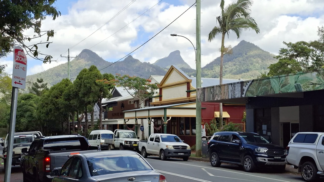

Uki, New South Wales
The name is a misunderstanding, and the locals have made peace with it. Prime red cedar logged from the surrounding hills was once stamped UK1 - bound for the United Kingdom, grade one - and the brand stuck to the bullock teams, the loading point, and finally the whole township until UK1 softened into Uki. It is the kind of accidental christening that suits this place. Tucked into the green folds of the Tweed Valley below the cloud-snagged peak of Wollumbin, Uki is a single curving street of timber shopfronts, a population of a few hundred, and a weekend reputation that pulls visitors from across the Northern Rivers.
Under the Cloud Catcher
Everything in Uki happens in the gaze of one mountain. Wollumbin - the peak European charts label Mount Warning - rises just north of the village, the eroded core of a volcano that once stretched from Byron Bay to the Gold Coast some twenty million years ago. To the Bundjalung people it is the Cloud Catcher, and on most mornings you understand the name literally, watching mist gather and tear around its summit while the valley below stays clear. The village sits roughly fifteen minutes south of Murwillumbah on the Kyogle Road, just past the turnoff into the World Heritage-listed national park that protects the mountain. Roads also climb in from Lismore and Nimbin to the southwest, and a back route threads east toward the coast at Brunswick Heads and Byron Bay.
The Butter Years
Before the cafes and the market crowds, Uki ran on cream. When the timber cutters had stripped the slopes - photographs from the early 1900s show the surrounding hills almost bare - dairy farmers moved into the cleared paddocks, and the white weatherboard Butter Factory at the edge of the village became the heart of the local economy. Farmers brought their cans, the separators hummed, and the district shipped butter out to the coast and beyond. The industry faltered in the 1960s, when a national rationalisation pushed many farmers to switch from milk to beef cattle, and sugarcane crept up the valley floor. The factory fell quiet. But the building survived, and today its old churns sit outside as monuments to the work that built the town.
A Weekend Kind of Place
Uki has reinvented itself as the Tweed Valley's village of choice for a slow Saturday. The single main street holds a general store, a bakery, a post office, a pharmacy and a clutch of cafes, and the restored Butter Factory now houses makers and markets rather than cream. The Mount Warning Hotel anchors the corner - a favourite lunch stop for touring motorcyclists and weekend drivers - though its survival was no certainty. Fire gutted the historic pub in February 2013, and the village watched a piece of itself burn. It was rebuilt and reopened in mid-2015, the timber verandahs back in place. Uki even has a literary alter ego: it is the model for the fictional village of Yurriki in Robert G. Barrett's 1989 novel The Godson.
Water, Pythons and Quiet Roads
The country around the village rewards anyone willing to leave the main street. Clarrie Hall Dam, about ten kilometres out, holds a reservoir that anglers rate among the finest freshwater fishing in New South Wales, its drowned valley fringed with rainforest. Gravel back roads and fire trails wander off toward Mount Jerusalem National Park and the alternative-lifestyle towns of the hinterland. The community itself skews older and well-travelled - the median age sits near forty-five, with a noticeable share of residents born in England, New Zealand and beyond - and it keeps a village rhythm: the Uki Pythons soccer club fields teams from six-year-olds to seniors, and summer touch football draws players aged six to sixty onto the same fields below the mountain.
From the Air
Uki sits at 28.42 degrees south, 153.33 degrees east, on the floor of the Tweed Valley about 4 km south of Wollumbin / Mount Warning, whose distinctive eroded volcanic peak (1,157 m) is the dominant visual landmark and an unmistakable navigation reference for the whole caldera. The village lies roughly 15 km inland from the coast at Tweed Heads. Nearest airport is Gold Coast Airport (YBCG / OOL) at Coolangatta, about 35 km northeast; Ballina Byron Gateway Airport (YBNA / BNK) lies about 70 km south. Best viewed from the east in morning light, when cloud typically wreaths the summit and the valley floor stays clear; the surrounding ranges generate rapid afternoon cloud build-up.
Nearby Stories
- David Fleay Wildlife Park 2.4 km away
- Bangalow 6.8 km away
- Purga Aboriginal Cemetery 48 km away
- Spicers Gap Road 61 km away
- Bald Rock National Park 88 km away
- HMS Porpoise (1799) 674 km away
- Wreck Reefs 703 km away
- SS Elingamite: Gold, Fog, and a Captain Wrongly Blamed 1817 km away