Wae Rebo: Seven Houses Above the Clouds
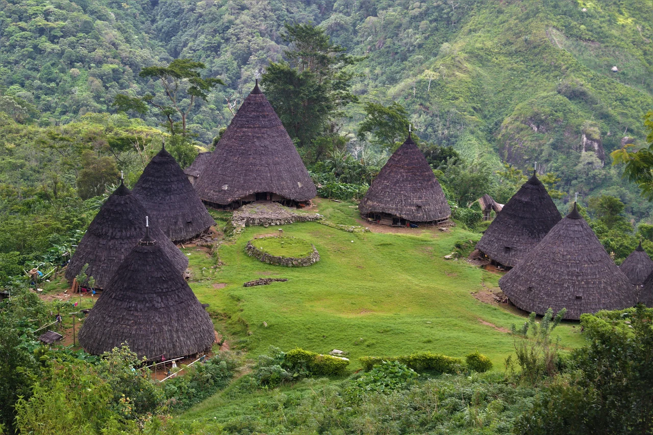
Seven houses. That is all. Seven cone-shaped structures thatched from peak to ground in lontar palm, arranged in a circle on a mountain clearing at 1,100 meters above sea level, each one corresponding to one of the seven peaks that ring the village like sentinels. To reach Wae Rebo, you hike for three hours through montane forest on Flores, climbing from the lowlands near Denge village into clouds that often swallow the settlement whole. When the mist parts, the village appears suddenly -- dark conical roofs against green slopes, woodsmoke curling from doorways, the sound of roosters and children carrying across a space that feels both ancient and impossibly intimate. There is no road. There is no cell signal. There are seven houses, about 1,200 people, and a way of life that was nearly lost before the world noticed it was worth saving.
Architecture as Philosophy
The Manggarai people call their traditional houses mbaru niang -- mbaru meaning house, niang meaning tall and round. Each structure rises in a steep cone, its palm-thatch skin reaching from apex to earth without interruption, so that the building resembles less a house than a vessel pointed at the sky. Inside, the cone is divided into five levels, and each level carries meaning. The first, lutur, is where families live and sleep. The second, lobo, stores food and goods. The third, lentar, holds seeds for the next planting. The fourth, lempa rae, reserves emergency food stocks against drought. The fifth and highest, hekang kode, belongs to the ancestors -- a sacred space for offerings that no casual visitor enters. The architecture encodes a Manggarai philosophy of preparedness and reverence: live on the ground floor, plan for the future in the middle, and keep the sacred above everything. When these houses began to deteriorate in the early 2000s, the village was not just losing shelter. It was losing a worldview made physical.
Rescue from the Outside
By 2006, Wae Rebo's traditional houses were failing. Coffee yields -- the community's primary cash crop -- fluctuated wildly as climate patterns shifted. Cinnamon and corn brought in some income, but not enough to fund the specialized repairs that mbaru niang construction demands. The community appealed to the Indonesian Ecotourism Foundation, known as Indecon, which began providing training in tourism planning, capacity building, and institutional management. In 2008, UNESCO Indonesia, working through Burung Indonesia, contributed clean water infrastructure and tourism service training. That same year, the Rumah Asuh Foundation -- dedicated to preserving traditional Indonesian houses -- secured private donations and corporate funding to rehabilitate the four surviving houses and rebuild three that had collapsed. Fifteen architects traveled from Jakarta to lead the reconstruction, working alongside villagers and local government officials. The result was not a museum restoration but a living repair: families moved back in, cooking fires were relit, and the houses resumed their role as the center of daily and ceremonial life.
The Tourism Bargain
Recognition came in layers. UNESCO listed Wae Rebo as a Cultural Heritage Conservation site in 2012. Indonesian television discovered it by the mid-2010s. TripAdvisor reviews and social media did the rest. Visitor numbers tell the acceleration: 1,136 in 2013, doubling to 2,061 in 2014, nearly doubling again to 5,090 in 2016, and stabilizing around 7,800 annual visits by 2017. In 2017, the Waerebo Cultural Conservation Institute earned over 2.2 billion rupiah, with another 645 million coming from souvenir and food sales by village cooperatives organized into coffee, weaving, chips, and handicraft groups. The distribution system is deliberate: 48 percent goes to profits shared among community members, 28 percent funds communal meals, 11 percent covers building maintenance, and smaller allocations support education, elder care, and the annual harvest ceremony. The money radiates outward too -- motorcycle taxi drivers, market traders, and accommodation owners in surrounding villages all benefit from the foot traffic that Wae Rebo generates.
Closed Doors, Open Questions
When COVID-19 shut down global travel, Wae Rebo closed its trails on March 16, 2020. The village remained sealed for nineteen months, until October 2021. During that silence, the community survived the way it had survived for generations before tourism existed: by farming. Coffee, corn, and cinnamon kept families fed. The enforced pause raised questions that the village is still answering. How much tourism is too much? The more visitors who climb the trail, the greater the pressure on water supplies, waste management, and the social fabric of a community where 1,200 people live in seven shared houses. In 2018, Wae Rebo received the Indonesia Sustainable Tourism Award in the Culture category. In 2021, it won the Indonesian Tourism Village Award as the nation's best tourist attraction. In 2024, the Spectator Index ranked it the second smallest and most beautiful town in the world. Each award brings more attention, and each wave of attention tests the community's capacity to remain what made it remarkable in the first place -- a village where architecture, agriculture, and ancestry still form a single unbroken thread.
From the Air
Located at 8.49S, 120.42E in the mountainous interior of western Flores, Indonesia. The village sits at approximately 1,100 m elevation in a mountain clearing surrounded by seven peaks. Not directly visible from high altitude due to dense forest canopy and frequent cloud cover, but the surrounding Manggarai highlands are prominent terrain features. Nearest airport is Frans Sales Lega Airport (RTG/WATG) at Ruteng, approximately 25 km to the southeast. Komodo Airport (LBJ/WATO) at Labuan Bajo is about 120 km west along the coast. The terrain is extremely mountainous with peaks exceeding 2,000 m; approach with caution in instrument conditions. Best viewed at 5,000-8,000 ft during dry season (April-November) for clearest mountain visibility. Cloud cover over the highlands is common, especially in the afternoon.
Nearby Stories
- Flight 6715: Vanished Over the Molo Strait 24 km away
- Where the Hobbits Grew Small: The Fossils of Mata Menge 27 km away
- The Month the World Didn't Know 68 km away
- Sumba's Hidden Kingdom of Wings 107 km away
- Sumba: The Sandalwood Island 114 km away
- The Bluff That Worked and the Storm That Didn't Care 140 km away
- Isuzu: The Cruiser That Refused to Sink 203 km away
- Ordinary Hunger: Life on Savu Island 219 km away