
Wearside
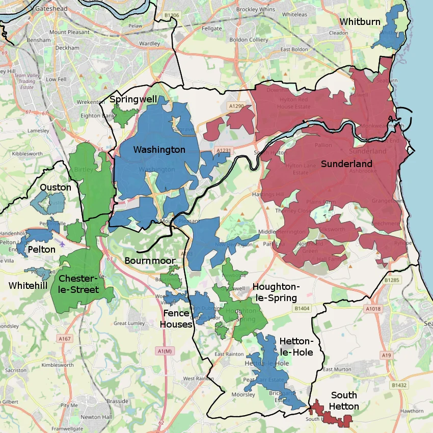
Follow the River Wear east from the Pennines and it tightens, deepens, then opens into the North Sea at Sunderland. The water did the work of naming the region long before anyone drew a boundary. Wearside is what the locals call it, and the name has stuck through enclosure, industry, war and the slow undoing of both. The official census name is the more bureaucratic Sunderland Built-up area, but no one in Houghton or Hetton calls it that. They call it Wearside, because the river is still the thing that ties a string of towns together.
Water First, Towns Later
The Wear cuts a deep gorge near Durham before swinging north and east, and the settlements along its lower reaches grew because the river offered both highway and harbour. Sunderland sits at the mouth, the largest part of the urban area that now spreads inland to Washington, Chester-le-Street and Birtley, with smaller fingers extending into County Durham and a sliver of Gateshead. These places were never a single town. They were a collection of villages that shared a watershed, then shared an economy, and eventually shared a name. The 2011 census counted them together as the Sunderland Built-up area, but the older word - Wearside - is the one that survives in conversation.
Coal and Keel
For roughly two centuries Wearside ran on two industries: shipbuilding and coal. Sunderland Docks built ocean-going vessels by the thousand, and pits like Monkwearmouth Colliery sank shafts deep beneath the streets to feed both the foundries and the export trade. The work was hard and the towns were built around it - rows of terraces, working men's clubs, miners' welfare halls, a chapel on most corners. Then the mid-twentieth century pulled the floor out. Shipbuilding contracted, then collapsed. Collieries closed one after another through the 1960s, 70s and 80s. What replaced them, in the places that found anything to replace them with, was lighter and thinner: call centres, retail parks, public-sector administration. Easington Colliery, just over the boundary in County Durham, became shorthand for towns that never quite recovered.
Sub-Divisions on Paper, Identities on the Ground
The Office for National Statistics divides Wearside into a tidy list of built-up area subdivisions, but on the ground the boundaries are messier. Houghton-le-Spring is not Hetton-le-Hole, and Hetton is not Washington, and Washington is emphatically not Sunderland - though all of them now sit within the same statistical envelope. The le-this and le-that suffixes are medieval echoes, French-flavoured leftovers from a time when scribes documented manors and parishes in Norman shorthand. The places kept the spellings. Locally, allegiance follows football and accent at least as much as administrative line. Sunderland AFC is the only professional club in the area; everything below that is amateur, including the long-running Wearside Football League where Easington Colliery AFC and Seaham Red Star still play.
After the Pit, the Press, the Yard
Two newspapers and two radio stations - the Sunderland Echo, 103.4 Sun FM and 107 Spark FM among them - still carry the local story, although the readers and listeners are fewer than they once were. Regeneration has been slow and uneven. Sunderland itself has rebuilt parts of its riverfront and seafront, drawing on cultural and digital industries to try to fill the hole the yards left. Other parts of Wearside have done less well, and the rejuvenation that does happen often arrives town by town rather than across the region. The thing that ties it all together is still the river. Walk along the Wear today and you can read the whole history - the dock cranes, the old colliery sites, the new housing - just by paying attention to the banks.
From the Air
Wearside is centred on the River Wear estuary at roughly 54.90 degrees north, 1.38 degrees west, with the urban area sprawling inland from Sunderland on the North Sea coast toward Washington and Chester-le-Street. Best viewed at 3,000-5,000 feet on a clear day, when the line of the Wear is unmistakable as it cuts inland from the coast. Nearest major airport is Newcastle International (EGNT), about 12 nautical miles north-west; Durham Tees Valley (EGNV) lies roughly 25 nautical miles south. The North Sea coastline forms the eastern edge, with the river mouth at Sunderland easy to pick out against the urban grid.
Nearby Stories
- Seaton Carew 2.7 km away
- HMS Unity (N66) 6 km away
- George Stephenson's Birthplace 6.1 km away
- Raby Castle 9 km away
- Cragside 15 km away
- Whitby Abbey 21 km away
- German submarine U-2367 46 km away
- Alexander L. Kielland (Platform) 277 km away