Zaamslag Castle
A piece of bridge timber was pulled out of the ground at Zaamslag in 1987. Dendrochronology placed the tree it came from somewhere between 1089 and 1103 - cut in the era when William II of England was king and the First Crusade was being preached at Clermont. That timber held up the bridge that carried lords across the moat of Zaamslag Castle. The castle is mostly gone now. The artificial hill it stood on - the motte, the locals call it Torenberg - still rises 3.3 meters above the Dutch ordnance datum in the heart of a quiet village on Zeelandic Flanders.
An Island That No Longer Is
When Zaamslag Castle was first built in the 12th century, it sat on an island. Zaamslag Island was a patch of dry ground in the wetlands east of Ghent, separated from the Flemish mainland by tidal creeks - about eight kilometers east-west, nine kilometers north-south. Three villages shared it: Zaamslag itself, the largest; Othene, probably the oldest; and Aendijcke. By 1335 the polders had crept in close enough that the island stopped being one. Today you would have to know the geology to see it - the modest height in the middle of Zaamslag village is the same dry rise that drew the first settlers a thousand years ago. The Torenberg motte was the highest point of all, and the lords of Zaamslag piled it higher with packed earth around 1100 to put a wooden tower on top.
From Timber to Brick
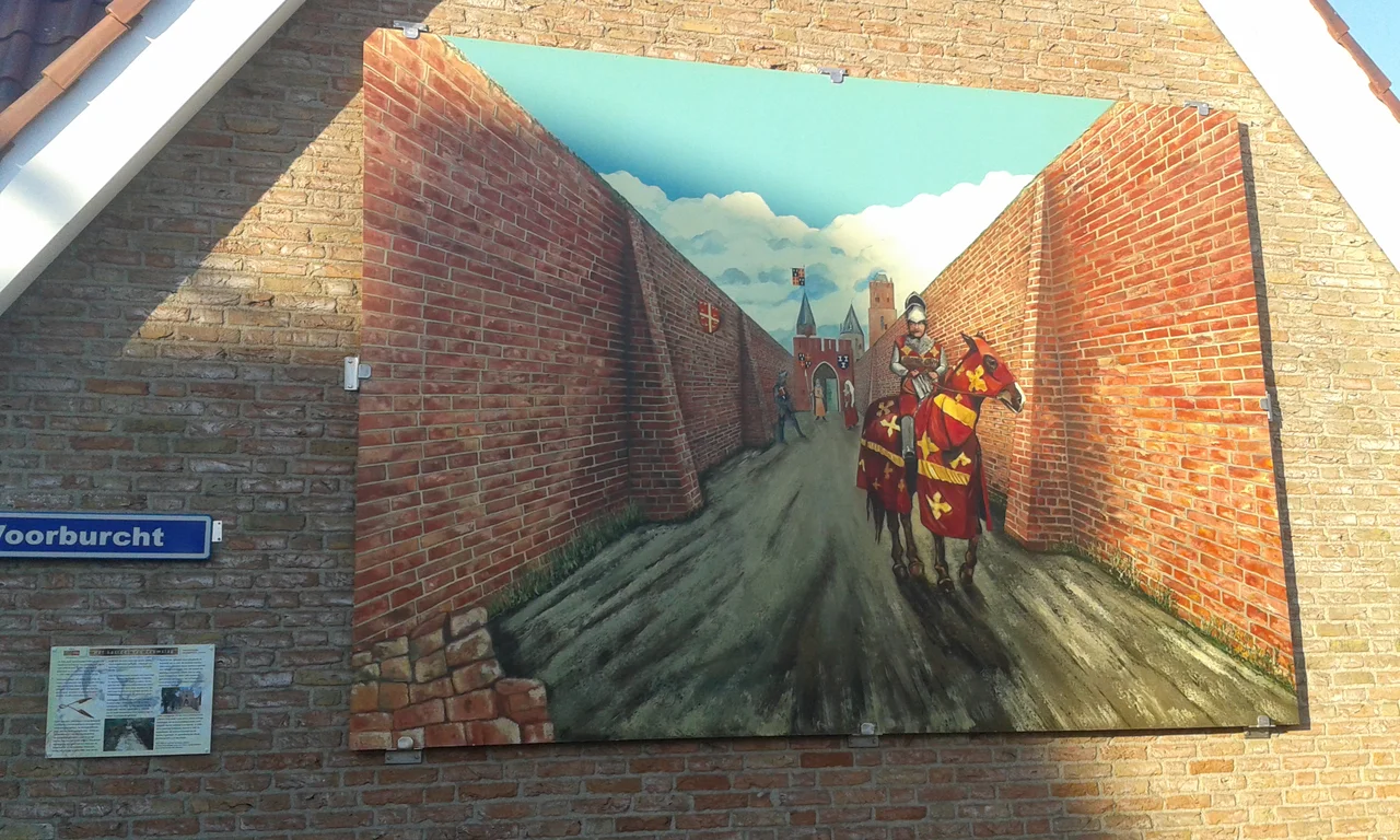
The first castle was wood and earth, in the standard motte-and-bailey pattern - a wooden keep on the artificial hill, a larger fenced outer bailey beside it with farm buildings, a moat around both, a bridge across the moat. By the second half of the 13th century the lords of Zaamslag had upgraded: the main castle became a brick structure, and the gate of the outer bailey was rebuilt as a brick tower with a square footprint. The brick they used can be measured down to the millimeter, because the 1987 dig recorded each course - 31 by 16 by 8 centimeters for the earliest gatehouse, dropping to 27 by 13 by 6.5 centimeters for the latest improvements. Smaller bricks were a 14th-century fashion. They appear in the dreefmuren - two parallel walls running from the moat toward the village, the long stone arms that turned the castle approach into a guarded corridor.
The Tower as a Lighthouse
A man named Jona van Middelhoven, born in the 17th century, saw the surviving tower of Zaamslag in his youth and described it after it was finally pulled down. It was square, about twenty meters wide, with a vaulted basement that had served as a prison. The top had embrasures for crossbowmen, and on a clear day the tower was visible all the way to Vlissingen across the Western Scheldt - close to twenty kilometers as the geese fly. It worked as a beacon. The lords of Borselen, who held Zaamslag in 1385, paid to keep the fortifications in good shape, and the castle survived the destructive war between Philip the Good and Ghent in the mid-15th century, though not without heavy damage. By the time the Eighty Years' War arrived, the lordship was old, but the walls were still standing.
The Dikes Are Cut
Between 1584 and 1586, the Dutch Republic deliberately destroyed the dikes around Zaamslag. The strategic logic was cold and effective: flood the land, deny it to the Spanish, control the Scheldt. The village and castle, both built above the ordnance datum, survived the immediate inundation. What they could not survive was abandonment. By 1587, the Zeeland authorities had granted official permission for the brick of nearby Saeftinghe church, of Zaamslag, and of other ruined buildings to be looted for new construction elsewhere. Still, the tower on the motte held on. In 1591 a small garrison of about fifteen soldiers was still posted at the castle. In 1593 the Zeeland government formally ordered that the tower not be destroyed. They simply did not maintain it. In 1697, more than a century after the dikes were cut, the tower behind the farmhouse called Torenhoeve was finally pulled down. Zaamslag was reclaimed in 1649-1650 and rebuilt, partly from its own old bricks.
What the Mound Still Knows
In 1970, the Torenberg was protected as a national monument - too late, as it turned out. When a 1983 storm wrecked the farm buildings on the outer bailey, Terneuzen municipality used the chance to build houses on top of the castle's archaeology. The Rijksdienst voor het Oudheidkundig Bodemonderzoek protested. The local history society protested. In the summer of 1987 the National Archaeological Service got six hasty weeks to excavate the outer bailey before the foundations went in. They found the gatehouse, the dreefmuren, the brick sewer wide enough to walk through, the wooden bridge pile from around 1100. Then the bulldozers came. The motte itself was spared, and on the corner of Plein and Voorburch streets in modern Zaamslag, a small marker reconstructs the entrance dreefmuren. Climb the small green hill called Torenberg today and there is nothing on top but grass. A thousand years under your feet. A tower that used to wink across the Scheldt to Vlissingen, gone. The mound remembers, in the patient way mounds do, with everything still buried inside it.
From the Air
Coordinates 51.311°N, 3.916°E, in the village of Zaamslag in Zeelandic Flanders, just north of Terneuzen. The motte (Torenberg) is a small green rise in the village - hard to spot from altitude, but the village layout still shows the old island geography. Best viewed at 1,500-2,500 ft. Nearest airports: Antwerp International (EBAW) 40 km southeast.
Nearby Stories
- Molenbeek-Ter Erpenbeek 2.5 km away
- Sint-Maartensdijk Castle 5.9 km away
- Westmalle Abbey 7.8 km away
- Hof van Cleve 8.1 km away
- Rotselaar 10 km away
- Sluis 12 km away
- NAC Breda 15 km away
- Southern Bight 78 km away