Zamość Fortress
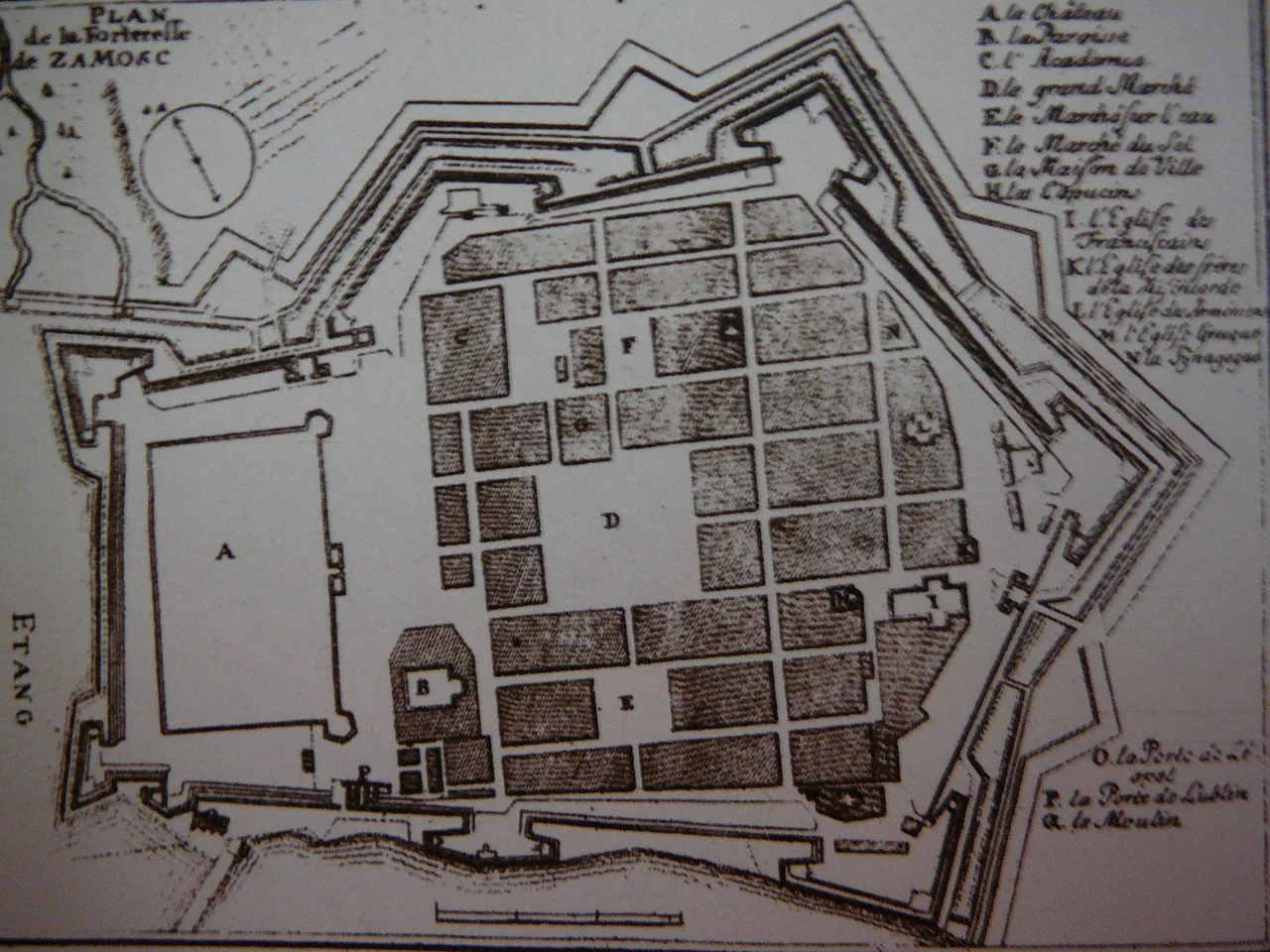
An Italian architect from Padua sat down in the late 1570s with a Polish chancellor and drew an ideal city. Bernardo Morando knew his Vitruvius and his Vignola; Jan Zamoyski knew that he wanted a private capital, named after himself, in the middle of nowhere on the eastern frontier of the Polish-Lithuanian Commonwealth. Together they invented Zamość: a Renaissance grid wrapped in seven bastions, fed by two small rivers diverted to fill the moat, defended by drawbridges at the Lublin, Lwów, and Szczebrzeszyn gates. UNESCO would call it the Padua of the North. Six armies tried to break in. Most failed. The one that finally walked in - in 1939, in field-grey uniforms - did not need to break the walls.
Morando's Geometry
Construction began in 1579. The foundation charter was issued in April 1580. The first castle went up almost immediately. The Arsenal followed in 1582, the Lublin Gate in 1588, the Lwów Gate in 1599, the Szczebrzeszyn Gate in 1603. Morando used the Topornica and Labunka rivers to fill the moat. Each gate had a drawbridge. The whole complex was finished in 1620, four years after Morando's death, by another Italian, Andrea dell'Aqua. The street grid inside the walls was laid out as a textbook example of Italian Renaissance urbanism: a long market square at the center, side streets at right angles, the chancellor's palace at one end, the cathedral at the other. The arcaded burgher houses around the market - the Armenian houses are the most famous, built by merchants who came from the Caucasus to trade Persian silk and carpets - still stand. Walking through them today is one of the closest experiences in Europe to seeing a 16th-century Italian theorist's drawing actually built at full size and lived in for four centuries.
Six Sieges
The Cossack-Tatar army of Bohdan Khmelnytsky and Tugay Bey arrived in November 1648. The defenders, about 4,700 soldiers under Ludwik Weyher, sheltered alongside refugees from Red Ruthenia, Podolia, and Volhynia. Cossack engineers drained part of the southern moat, but winter was approaching and Khmelnytsky's force was inadequate. Both sides signed a truce; the Cossacks accepted 20,000 talars and went home. In 1656, during The Deluge, the Swedes of Charles X Gustav showed up. Their artillery wasn't heavy enough; they withdrew within days. According to legend, when Swedish envoys demanded surrender, Jan Zamoyski - nicknamed Sobiepan, Lord-Of-Himself - answered: I am the Lord for myself and I will not give Zamość to the Swedes. In 1703 the Swedes returned during the Great Northern War; this time the small Polish garrison surrendered. In 1809, during the Napoleonic Wars, Polish and French troops under Jozef Poniatowski took the fortress from the Austrians in a four-hour night assault on the Lublin Gate. The longest siege came in 1813, when 3,000 Polish soldiers held out against the Russians for eight months. The last siege was in 1831, during the November Uprising; Zamość was the final point of Polish resistance to fall, on 21 November. Tsar Alexander II officially closed the fortress in 1866 and most of the walls were demolished.
What the Walls Could Not Stop
By 1939 the fortress was decorative, the bastions softened into parks. None of it mattered when the Wehrmacht arrived. Zamość lies in the Lublin region, and the Nazi planners had a special use for it. In late 1942 the SS launched the first major test of Generalplan Ost - the long-term project to clear Slavic populations from eastern Europe and resettle the land with ethnic Germans. About 110,000 Polish residents of roughly 300 villages around Zamość were forcibly expelled from their homes. Many were sent to forced labor or to Auschwitz. Around 30,000 children were taken from their parents during the operation; those judged racially valuable were sent to German families for Germanization, while the others were murdered or worked to death. Some of the children were eventually identified and brought home after the war. Many never were. The Zamość Children, as they came to be called, are one of the bleakest chapters of the German occupation of Poland - and a chapter that did not happen at the front of any battlefield, but in a part of the country whose Renaissance architecture had survived four centuries of war.
The Rotunda
One of the surviving fragments of the fortress is the Rotunda, a circular 19th-century gunpowder magazine outside the main walls. During the German occupation it was used as a transit camp and execution site. About 8,000 people - Poles from Zamość and the surrounding region, including members of the resistance - were murdered there between 1940 and 1944. Today the Rotunda is a museum. The cells around the inner courtyard are dedicated to those who were held and killed inside; the photographs and personal effects refuse to let the numbers stay numbers. It sits a short walk from the marketplace, where tourists eat ice cream under Morando's arcades. The two facts coexist. They have to.
Padua of the North
In 1992 UNESCO inscribed Zamość on the World Heritage list as one of the classical monuments of Renaissance urban planning in Europe. The argument is straightforward: very few ideal Renaissance cities were ever actually built. Most exist as drawings, or as the partial centers of cities that grew around them. Zamość exists as a working town. The geometry that Morando drew in the 1570s is still the geometry residents walk through to buy bread. The arcaded houses still face onto the market square. Concerts happen at the cathedral Zamoyski commissioned. The grid is alive. It survived six sieges from outside its walls, and a far worse one from within them, and it is still there - a small Italian city in eastern Poland that argues, by simply continuing to exist, for the dignity of the Polish countryside that the 20th century tried to erase around it.
From the Air
Coordinates 50.717°N, 23.253°E. The historic center of Zamość is recognizable from the air as a near-perfect rectangle of dense Renaissance street grid, with traces of the bastion outlines visible in the surrounding parks. Best viewed at 3,000-5,000 feet AGL in clear conditions. Nearest airport is Lublin (EPLB), about 100 km northwest; Rzeszów-Jasionka (EPRZ) lies roughly 130 km southwest.
Nearby Stories
- Zymne Monastery 31 km away
- Sobibor Museum 32 km away
- Lublin 35 km away
- Lublin Ghetto 61 km away
- Lviv High Castle 68 km away
- Siege of Przemyśl 74 km away
- Golden Rose Synagogue (Lviv) 82 km away
- Byaroza Monastery 188 km away