1951 Eruption of Mount Lamington
In the village of Sangara, forty-odd kilometres north of Kokoda, Sunday morning was ordinary. Children were playing. Women were preparing food. Men were walking between gardens. The mountain that rose to the south was called Sumburipa in the Orokaiva language, and nobody thought of it as dangerous. It was just there, forested, quiet, the way it had been for all of living memory. At 10:40 a.m. on 21 January 1951, a black plume rose 50,000 feet into the tropical sky. Within a minute or two, a pyroclastic flow hot enough to melt plastic lampshades but not to ignite wood, moving at roughly seventy kilometres per hour, surged down the northern flank and erased the village. Up to 94 per cent of Sangara's people died. In total, 2,942 people were killed, most of them Orokaiva. The mountain the newspapers would call Mount Lamington had declared itself a volcano for the first time in recorded history.
A Mountain Nobody Recognised
Mount Lamington rises 1,680 metres above the coastal flats north of the Owen Stanleys. It is part of the Hydrographers Range, which is itself a heavily eroded stratovolcano of mostly Pleistocene origin, but the newer peak had not erupted in any historical memory, European or Orokaiva. Dense forest covered its summit domes. Volcanologists at the time did not classify it as active. When minor explosions and earthquake swarms began on 15 January 1951, the local District Commissioner Cecil Cowley sent messages to Port Moresby asking authorities and a volcanologist to come and assess the activity. The requests went unanswered. There was, simply, no administrative structure for a volcanic disaster in a territory where the administrators had not acknowledged that this place was a volcano. Tony Taylor, the only volcanologist in the territory, was studying Rabaul's caldera several hundred kilometres to the east. He arrived the day after the main eruption, too late for the warning, in time to become the lead investigator.
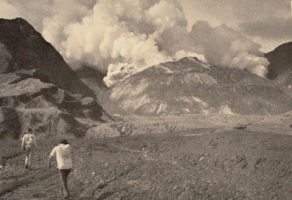
What a Pyroclastic Flow Looks Like
The eruption column collapsed. That sentence is a bit of technical volcanology that conceals a physical event so extreme it borders on incomprehensible. When the dense ash cloud over the summit could no longer hold itself up, it fell, hot, dense, heavy with rock fragments, and spread out across the mountainside as a fluid. Eyewitnesses on the coast described it as "like toothpaste from a tube." It moved at approximately seventy kilometres per hour and destroyed everything in its path for several kilometres. Tony Taylor and his colleagues later pieced together the physics from the ruins. Penicillin vials in a hospital showed the flow had reached 200 degrees Celsius for about 90 seconds. A cotton reel and a sewing-machine drive belt in Higaturu were unscathed, but a plastic lampshade in the same house had melted. Two violins survived intact inside a residence whose walls had been stripped away. A jeep was found hanging in the remains of a tree, which told Taylor that vortices had formed inside the flow, with internal winds of perhaps seventy-five kilometres per hour. The devastation zone around the volcano stretched for kilometres. The flow moved furthest northward, because the crater had breached in that direction, funnelling the avalanche toward the villages of the Orokaiva.
Sangara, Higaturu, and the People Who Were There
The Orokaiva are a Melanesian people whose gardens, villages and cultural sites had occupied the northern foothills of the Hydrographers Range for centuries. Sangara was the village most directly in the pyroclastic flow's path, and nearly everyone there was killed. Higaturu, the Australian administrative station, was obliterated to the floors of its buildings; hundreds died from the heat. The bodies recovered showed a particular pattern. Victims had not died from flying debris or collapsed buildings. They had died from inhaling superheated ash that caused swelling, exfoliation and haemorrhage in the respiratory system, followed by asphyxiation. Rigor mortis had seized many of them mid-gesture, sitting, kneeling, reaching. The same conditions had been observed in victims of Mount Pelée in Martinique in 1902. Among the survivors was the anthropologist Marie Reay, who was living in the area at the time. She experienced a mental breakdown the following year. One Orokaiva woman took her own life after finding the remains of her husband and child. No counselling was offered. Five thousand people lost their homes. Twenty-two of the first forty injured survivors brought to hospital died within twenty-four hours. The survivor stories that remain are fragments: a woman near Amonikiarota whose thin cotton dress shielded her skin from the fine glass of ash; an Orokaiva man who was knocked into the Ambogo River, unconscious briefly, who surfaced to find his throat burning but who then sank below the water just as the hottest part of the flow passed overhead. He was the only one of three to survive.
Response, Refuge, and the Long Road to Saiho
The administration in Port Moresby did not learn of the scale of the disaster until the morning of 22 January. RAAF C-47 Dakotas brought in tents, medical supplies and food; the Australian Red Cross donated blood plasma; the administrative ship Huon sailed overnight from Lae to Popondetta with medical staff. A road linking Gona to Kokoda that ran north of Mount Lamington, undamaged, became the artery along which injured people were carried out and rescuers came in. At Wairopi on the floodplain of the Kumusi River, four thousand refugees gathered. The Kumusi supplied drinking water. The camp held until mudflows from the ruined mountainside silted the river channel and caused flooding on 8 and 19 February that washed the evacuation site away. Survivors walked to a new site called Ilimo. Meanwhile, whooping cough, already a concern before the eruption, spread in the crowded camps; medical workers pushed dysentery, typhoid, tuberculosis and pneumonia immunisations through populations traumatised by loss and living in the rain. By the end of February more than 3,840 whooping cough vaccinations and 3,150 typhoid injections had been administered. Plans for permanent resettlement began almost immediately. Administration officials and Orokaiva representatives agreed the old villages were not safe to rebuild. A new network of villages called Saiho was built along a road linking Waseta and Popondetta, under the supervision of administration officers. An eleven-ward hospital was constructed alongside. By mid-May most of the refugees had moved to Saiho. Ilimo closed on 1 June.
What Grows Back
Three days after the eruption, a fungus called Neurospora was discovered growing in the ash deposits, an early coloniser of burned landscapes. Within a week, taro plants were sprouting in villages on the edge of the devastation. Yam, sweet potato and banana followed. By early 1952, grass covered the slopes. By late 1952, trees stood 15 feet tall. The coffee and rubber plantations that had been flattened regrew enough to sustain the local population again. The volcanic crater itself continued to breed lava domes through 1956, with new domes forming and collapsing in sequence, but the pyroclastic threat gradually receded. In November 1952, the Mount Lamington Memorial Cemetery was dedicated at Popondetta, its centrepiece a large white Christian cross. Bodies from Higaturu were exhumed and reburied there. Tony Taylor received the George Cross for his work in assessing ongoing volcanic danger, including flights over the erupting crater. Fourteen other service awards went to missionaries, pilots and administrative staff. The 2,942 Orokaiva and administration dead received the memorial, the cross, and a place-name in the international literature of volcanology; the Plinian-style eruption at Lamington became a textbook case. What their descendants received was Saiho, and the knowledge that the forested mountain to the south was never only a mountain.
From the Air
Mount Lamington rises to 1,680 metres at 8.95 degrees south, 148.15 degrees east, about 40 km southwest of Popondetta in Oro Province. The peak is part of the Hydrographers Range, a small coastal range adjacent to the Owen Stanley Range. A horseshoe-shaped crater opens to the north, and a broad avalanche valley extends northward from the breach, visible from altitude as a lighter-coloured scar in the forest where the 1951 pyroclastic flow scoured the landscape. Recommended viewing altitude 6,000 to 10,000 feet. Nearby airports: Girua (AYGR) near Popondetta 40 km north-northeast, Kokoda (AYKO) 45 km west, Jacksons International Port Moresby (AYPY) 180 km southwest across the Owen Stanleys. The volcano remains monitored and is considered potentially active.
Nearby Stories
- Battle of Ioribaiwa 21 km away
- Kokoda Track 36 km away
- Tufi 70 km away
- Sirinumu Dam 72 km away
- Battle of the Bismarck Sea 152 km away
- Battle of Lababia Ridge 171 km away
- Battle of Goodenough Island 172 km away
- Japanese Submarine Ro-103 226 km away