Battle of Ioribaiwa
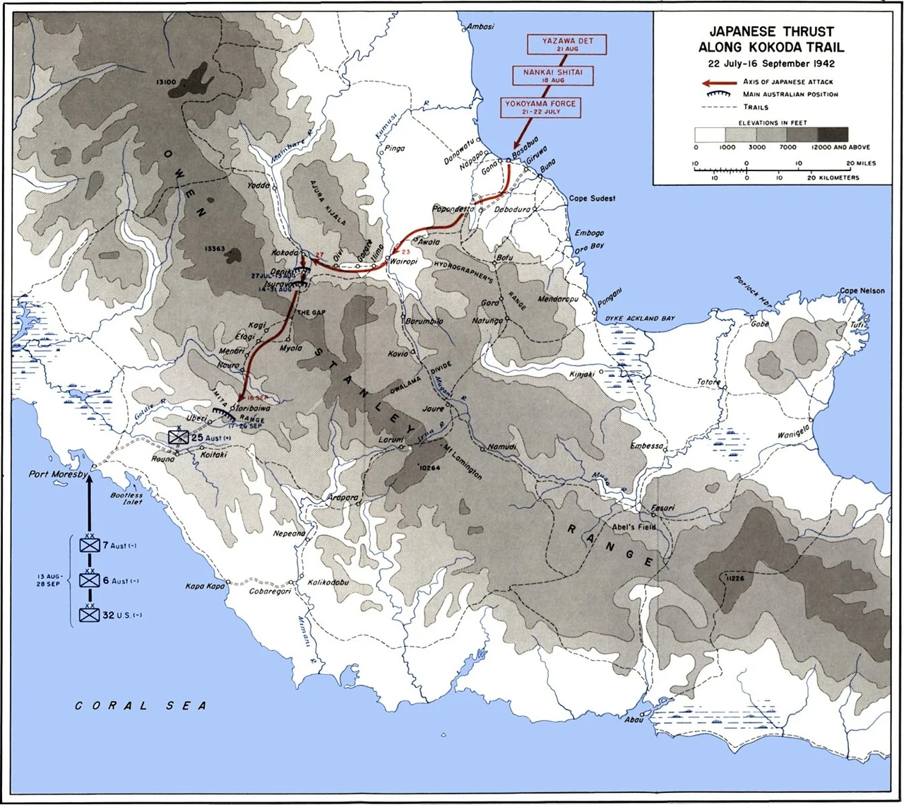
From Ioribaiwa Ridge on a clear night in September 1942, the glow of Port Moresby was visible across the intervening hills. Japanese troops of the 144th Infantry Regiment had fought their way 160 kilometers south through jungle and mountain to reach this vantage - close enough that their goal shimmered on the horizon, close enough that they believed they could see the end of their march. They could not. This would be the furthest south any Japanese soldier reached on the Kokoda Track. Over three days, between 14 and 16 September, the last of three Australian defensive actions on the track would slow them just enough that the war, and the geography of the Pacific War itself, would turn against them.
Two Armies on the Edge of Collapse
Both sides arrived at Ioribaiwa spent. The Japanese South Seas Detachment under Major General Tomitaro Horii had fought through Kokoda, Isurava, Eora Creek, and Mission Ridge since late July - each battle a win, but each win bought with dwindling rations and lengthening supply lines. Horii's men were eating captured stores and sometimes less. Opposite them, the depleted Australian 21st Brigade - the veteran 2/14th, 2/16th, and 2/27th Battalions - had been in continuous contact for weeks, reduced to composite units by casualties. Reinforcements had arrived: the fresh 25th Brigade under Brigadier Kenneth Eather, bringing the 2/25th, 2/31st, and 2/33rd Battalions to the ridge. The newcomers carried full packs and clean rifles. The survivors they relieved looked, in the words of one officer, more like ghosts than soldiers.
The Fight on the Ridge
On 14 September, half of the III Battalion, 144th Infantry stepped off into attack along the main track, supported by a quick-firing mountain battery whose shells cracked through the canopy above Australian positions. They hit booby traps first - trip wires the composite 2/14th-2/16th Battalion had strung through the forest - then a wall of small-arms fire. The Japanese pressed through both and pushed the Australians back in the centre. The II Battalion tried to flank west and ran headlong into the 2/31st, sitting on a position Japanese scouts had thought unheld. Artillery fire that day cut into the thinned Australian line in the centre. Eather watched his forward units bleed and reached a commander's conclusion: Ioribaiwa could not be held as a launching pad for counter-attack, even if held as a defensive position. He ordered withdrawal four kilometers south to Imita Ridge - the last ridge before Port Moresby.
What the Japanese Did Not Know
Horii's men took the ridge on 16 September and looked south into nothing. Beyond Imita lay the coastal plain, Port Moresby, and - they believed - the prize. But they did not have the food to reach it. The 144th and 41st Infantry Regiments had marched for weeks on supplies hand-carried over the Owen Stanley Range by Papuan labourers and their own soldiers. Rice ran out. At the same moment, American forces were grinding down Japanese troops on Guadalcanal, and Japanese forces at Milne Bay had just been thrown back into the sea by Australian defenders - the first land defeat of the Japanese Army in the Pacific War. Imperial General Headquarters in Tokyo decided Guadalcanal was the priority. On 8 September, Horii had already been ordered to halt offensive operations. By early October, his army that had won every battle was marching back north, pursued now by the same Australians it had pushed south.
A Turning Kept Quiet
No dramatic breakthrough took place at Ioribaiwa. No brilliant maneuver, no surrender. The Japanese won the tactical fight and withdrew from the strategic one - driven back by logistics and distant battles on Guadalcanal and Milne Bay as much as by the Australians in front of them. Yet Ioribaiwa remains the point where the Japanese advance on Port Moresby died. The battle honour "Ioribaiwa" was awarded after the war to the 3rd, 2/14th, 2/16th, 2/25th, 2/31st, and 2/33rd Infantry Battalions - a roll that reads, on paper, like any of a hundred Australian engagements. What it does not capture is the condition of the men who earned it: soldiers who had walked and fought back from Kokoda, survivors of a campaign whose dead were still being buried in the jungles behind them.
The Ridge Today
Ioribaiwa Ridge sits in dense rainforest about forty kilometers north of Port Moresby, on the modern trekking route used by thousands of Australian walkers each year. Trekkers pass the weapon pits, still visible as depressions in the ground, and the ridge where the Japanese advance reached its southernmost limit. Local Koiari villagers maintain parts of the track and, for generations, have looked after the ground their grandparents watched a war arrive and depart. Their ancestors served as carriers and stretcher-bearers during the fighting, hauling ammunition up and wounded men down. Australian soldiers called them "fuzzy wuzzy angels" - a term coined in that moment of mutual dependence. The men behind the name had families, villages, and a land that became a battlefield through no decision of their own.
From the Air
Ioribaiwa Ridge sits at 9.31 degrees south, 147.56 degrees east, in the southern foothills of the Owen Stanley Range about 40 km north-northwest of Port Moresby. The nearest airport is Jacksons International (AYPY/POM) at Port Moresby, 35 nautical miles south. Recommended viewing altitude is 6,000 to 8,000 feet to clear the ridgeline and appreciate how the terrain descends toward the coastal plain. Dense tropical canopy obscures ground detail; the ridge line itself is the navigational reference. Heavy afternoon cloud buildup is common during wet season (November-April).
Nearby Stories
- Sirinumu Dam 1.2 km away
- 1951 Eruption of Mount Lamington 16 km away
- Airlines PNG Flight 4684 29 km away
- Kokoda Track 46 km away
- Battle of Wau 183 km away
- Wau 212 km away
- Milne Bay Province 234 km away
- All Saints Anglican Church, Darnley Island 350 km away