The Day Seririt Fell Silent
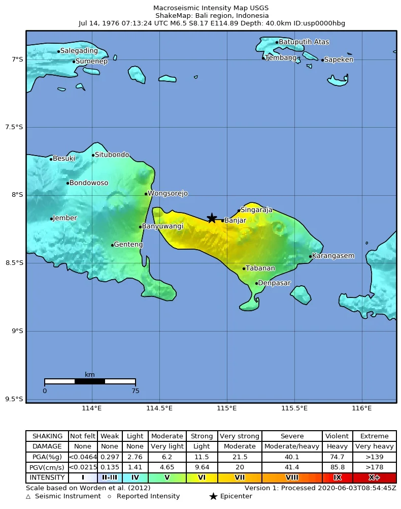
Seririt was a small market town on Bali's northern coast, the kind of place where children walked to school through streets lined with temples and family compounds. On the morning of July 14, 1976, the ground beneath those streets ruptured. A magnitude 6.5 earthquake struck five kilometers south of the Bali Sea coast in Buleleng Regency, and for nearly a minute the earth shook with a violence that turned masonry into rubble. When the shaking stopped, Seririt had effectively ceased to exist. Reuters would describe the town as "flattened," reporting that almost all buildings and bridges had collapsed. Across Buleleng and neighboring regencies, 573 people were dead, 4,000 were injured, and an estimated 450,000 had lost their homes.
Forces Beneath the Island
Bali sits on one of the most tectonically active zones on Earth. The island is part of the Sunda Arc, formed where the Australian tectonic plate dives beneath the Sunda plate at a rate of 7.5 centimeters per year. That slow, relentless collision generates enormous stress along the subduction interface and a system of thrust faults running north of the island. The July 14 earthquake originated at a depth of roughly 25 kilometers, though some estimates place the hypocenter as deep as 40 kilometers. Bali had been struck before -- a magnitude 6.6 earthquake in 1917 killed 1,500 people -- and would be struck again, with a 6.5 magnitude quake in 1979 killing 27 more. The geology is implacable. The plates do not stop moving, and the faults do not stop accumulating strain.
Trapped in the Schoolhouse
Among the first images to reach the outside world was the story of a school in Seririt where at least 200 students were trapped beneath a collapsed building. Rescue workers pulled ten children's bodies from the rubble on the day of the earthquake itself. Six more were recovered in the days that followed. In all, more than 60 students died in the collapse of that single school -- children who had arrived that morning expecting an ordinary day of lessons. The exact name of the school has been lost to incomplete records, but the scale of the tragedy made it the focal point of international media coverage. Beyond Seririt, the destruction radiated outward. A 60-bed hospital in the town of Negara was completely destroyed. Bali's only Buddhist monastery, the Brahma Vihara Arama in Banjar village, four kilometers from Seririt, suffered severe damage. In Buleleng Regency alone, up to ninety percent of houses were seriously damaged or destroyed.
Help Arrives by Sea and Air
The relief effort mobilized with surprising speed. The Indonesian Red Cross and local government, led by the governor of Bali, established a provincial relief control center and met the emergency needs of survivors within four days. In-country contributions exceeded $900,000. International help followed quickly. On July 17, an Australian destroyer escort was diverted from its course to Singapore, and at least 250 Royal Australian Navy personnel came ashore in Seririt to repair electrical infrastructure and restore power. Two first aid posts were set up in neighboring villages. The U.S. Ambassador to Indonesia purchased $6,000 worth of lanterns and sleeping mats for distribution by CARE. By July 22, the Indonesian government had requested blankets, tents, and cots from the United States, and the Office of U.S. Foreign Disaster Assistance committed over $200,000 to supply them from stockpiles in Singapore. USAID co-financed a $240,000 grant for the construction of a thousand low-cost houses.
Medics in the Mountains
Not all the damage was accessible by road. In the mountainous sub-district of Busung Biu and other highland areas, the earthquake had destroyed bridges and severed roads, cutting off communities from outside help. When a Singapore Armed Forces medical relief team of 20 personnel arrived on July 27 with 3,500 kilograms of medical supplies, they discovered they would have to trek into mountain towns on foot, carrying equipment by hand. During their mission, the Singaporean medics experienced three additional damaging tremors -- aftershocks strong enough to collapse weakened structures around them. Working alongside Indonesian Red Cross teams and medical personnel from the universities of Bandung and Diponegoro, the SAF mission provided consultations, treatment, and immunizations to more than three thousand people before departing on August 15. The image of foreign soldiers hauling medicine up mountain paths captures something essential about disaster response: that the last mile is often the hardest, and the most important.
What the Stones Remember
Bali rebuilt, as it always does. The monastery at Banjar was repaired. New houses rose where old ones had fallen. But the 1976 earthquake left marks that statistics alone cannot convey. Over 900,000 people had lived in the three regencies most affected -- Buleleng, Jembrana, and Tabanan -- and for those who survived, the memory of a minute when the ground betrayed them became part of the island's collective experience. Three years later, in December 1979, another earthquake of the same magnitude struck southeastern Bali, killing 27 and displacing a similar number of people. The pattern is geological fact: Bali will shake again. The temples and family compounds will be rebuilt again. In a place where Balinese Hinduism teaches cycles of creation and destruction, the earthquakes are not exceptions to the island's story. They are woven into it.
From the Air
Coordinates: 8.23°S, 114.78°E (epicenter in northern Bali, Buleleng Regency). The affected area stretches along Bali's northern coast, centered on the town of Seririt, approximately 65 km northwest of Denpasar. Best viewed at 5,000-8,000 feet following the northern coastline. The mountainous interior south of the coast shows the rugged terrain that complicated relief efforts. Nearest airports: WADD (Ngurah Rai International, Denpasar). The Bali Strait is visible to the west, separating Bali from Java.
Nearby Stories
- Pura Kehen 5.2 km away
- Pura Ulun Danu Batur 9.3 km away
- Blue Fire and Bitter Water: Ijen Volcano 13 km away
- Bali 25 km away
- Java's Little Africa 47 km away
- Battle of Makassar Strait 50 km away
- Where Three Worlds Meet: The Great Mosque of Sumenep 110 km away
- Shaken Foundations: The 2021 East Java Earthquake 192 km away