.jpg)
1986 João Câmara earthquake
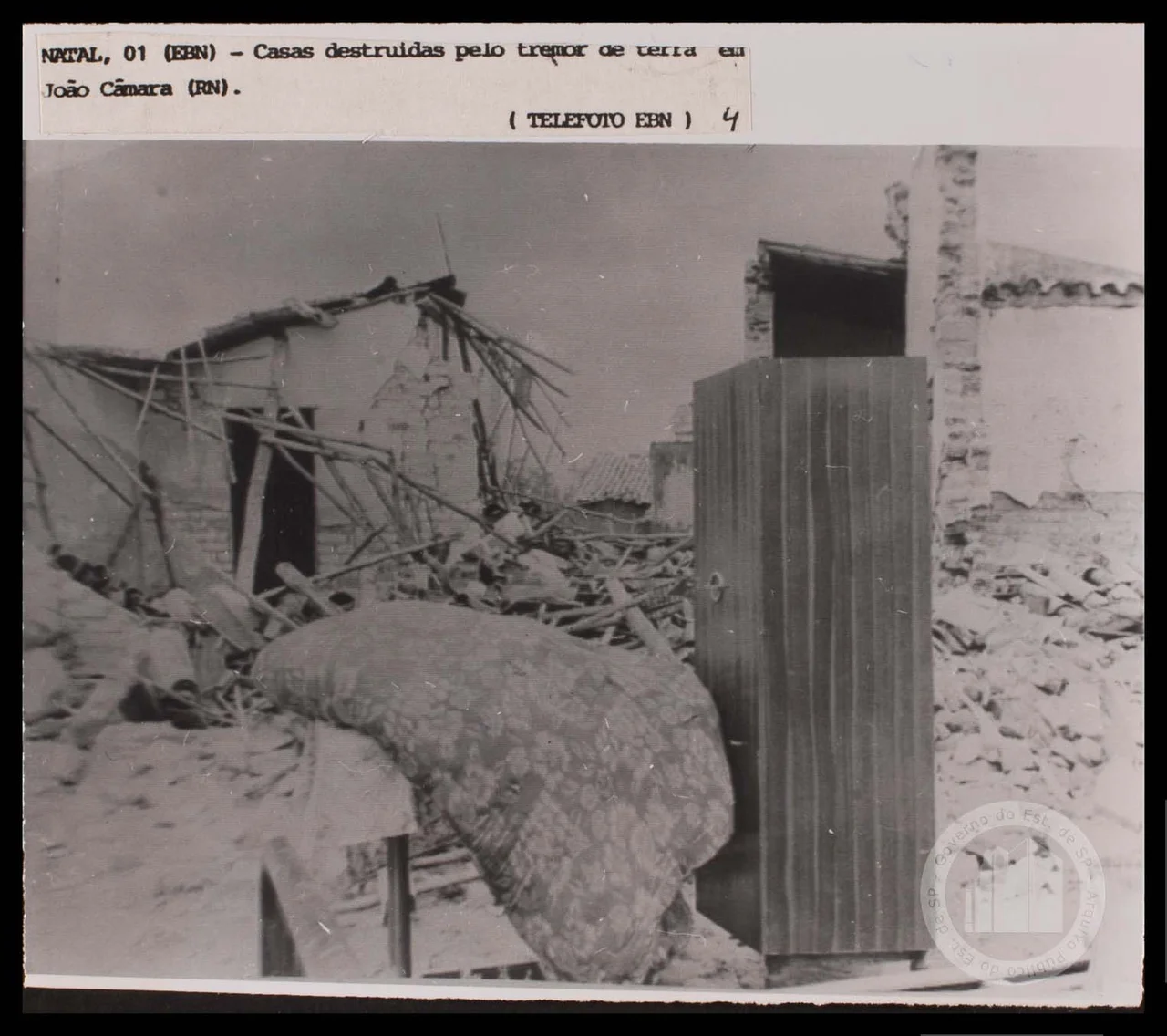
At 02:19 on the morning of 30 November 1986, the ground in João Câmara moved. It was a magnitude 5.1 earthquake — not catastrophic by the standards of the Pacific Rim, but felt across northeastern Brazil, from Natal to Mossoró, in a country that almost never expects to feel anything at all. Before the sun came up, the walls of the town's church had partly collapsed; more than four thousand houses were damaged or destroyed; the local hospital was in ruins. More than ten thousand people left their homes that week — some because the homes were gone, others because they feared landslides or another shock. Brazil had not experienced a tremor like this in living memory.
The Swarm
The 5.1 was the main act, but it was not alone. It was the apex of an earthquake swarm that had begun on 5 August 1986, when a magnitude 3.3 was strongly felt in João Câmara, a town of about 22,000 people in the state of Rio Grande do Norte. More 3.0-magnitude events followed through September, the largest a 4.2. The sequence quieted. Then, three months later, the mainshock struck — and behind it came weeks of aftershocks, with the largest at 4.4, continuing through December and January. The rate declined through 1988. On 10 March 1989 the sequence reignited with another 5.0. In total the swarm produced more than a thousand recorded events, including at least fifteen above magnitude 4.0. Seismologists at UFRN in Natal eventually traced the activity to a single structure — the Samambaia Fault — on which southwest-to-northeast strike-slip motion was slowly relieving stress locked into very old rock.
Deep Time Below a Small Town
Brazil is not supposed to shake. The country sits squarely in the interior of the South American plate, far from the Andean subduction zone to the west. But a continental interior is not motionless. Much of Brazil lies over the Brazilian Shield, a province of metamorphic rock knit together from four cratons — ancient blocks of crust — by collisions that happened between 1 billion and 540 million years ago. These Neoproterozoic collisions are called the Brasiliano orogeny. The suture zones left behind are structurally complex, cut by ancient shear zones that still concentrate stress. The Borborema Province, where João Câmara sits, covers roughly 400,000 square kilometres of northeastern Brazil and is laced with five sub-provinces and many faults. Northeastern Brazil is the country's most seismically active region; a 5.2 had struck nearby in Ceará in 1980. The São Francisco and São Luís cratons, between which the Borborema lies, are essentially pushing on it. Every so often the rock answers.
A Town of Timber and Concrete
What happened above ground depended on how the ground had been built upon. Most of João Câmara's older houses were made of brick, stone, or sun-dried adobe, with poor mortar and tiled roofs. The 5.1 shook these hardest: cracks opened in walls, roof tiles slid to the ground, whole walls collapsed in the worst cases, including part of the town church. Newer concrete buildings rode out the shaking with little or no damage. The Brazilian Army developed a replacement-house design — timber panels with concrete infill — and built about 500 of them to replace homes that could not be salvaged. A seriously damaged hospital and several schools were rebuilt in reinforced concrete. The contrast was a simple engineering lesson, learned at the cost of people's homes: brittle walls crack; ductile frames flex; structure choice is destiny.
The People Who Left
More than ten thousand people were displaced by the swarm. Most of them were not injured, but they were frightened — by the relentless rhythm of aftershocks, by the cracks in their walls, by the persistent possibility of a landslide on a hillside that had never moved before. Families camped with relatives in Natal and Mossoró; others slept outdoors in improvised tarpaulin shelters. The town's population of roughly 22,000 had never contemplated earthquake resilience as a civic problem. They were learning. The Brazilian Army arrived, as did federal emergency officials. Reconstruction took years. There were no deaths directly caused by the main shock — a genuinely lucky outcome, attributable in part to the time of day, when most people were awake but many were still indoors. But the dislocation was real, and the fear was deep.
A Quiet Country Listens
The João Câmara earthquake changed how Brazil thought about its own geology. UFRN's seismology laboratory, Labsis, has become a regional centre for studying the Borborema's earthquakes, and a new generation of seismic networks has been deployed across northeastern Brazil since the late 1980s. The Samambaia Fault is one of the most closely monitored structures in the country. There will be more quakes — that is not in doubt. But the rhythm of a stable continental interior is measured in decades and centuries, not years. Each event, when it comes, is a reminder that the deep past is still moving beneath the feet of the present. Forty years on, João Câmara is quiet again. The church was rebuilt. The Army's small concrete houses still stand. Somewhere below them, the rock keeps settling into a new shape.
From the Air
The 1986 epicentre is near 5.41°S, 35.90°W in the state of Rio Grande do Norte, about 70 km west of Natal. The surrounding landscape from altitude reads as a mosaic of caatinga scrub, small agricultural plots, and scattered rock outcrops, with the Atlantic coast visible to the east. The nearest major airport is Natal–Governador Aluízio Alves International (SBSG), roughly 35 nm east; Mossoró (SBMS) lies about 100 nm west-northwest. Weather in Rio Grande do Norte is dominated by the easterly trades; the dry season (August–January) brings excellent visibility with occasional haze from biomass burning, while the short wet season (February–May) produces brief afternoon showers. Cruising altitudes of 6,000–9,000 ft give the best sense of the low relief and the fault-controlled drainage of the Borborema Province.
Nearby Stories
- Touros 19 km away
- Açu, Rio Grande do Norte 45 km away
- Furna Feia National Park 105 km away
- Canoa Quebrada 194 km away
- Atol das Rocas Biological Reserve 233 km away
- SS Annibal Benévolo 679 km away
- SS Baependy 698 km away
- Roncador Field 1876 km away