Alte Weser Lighthouse
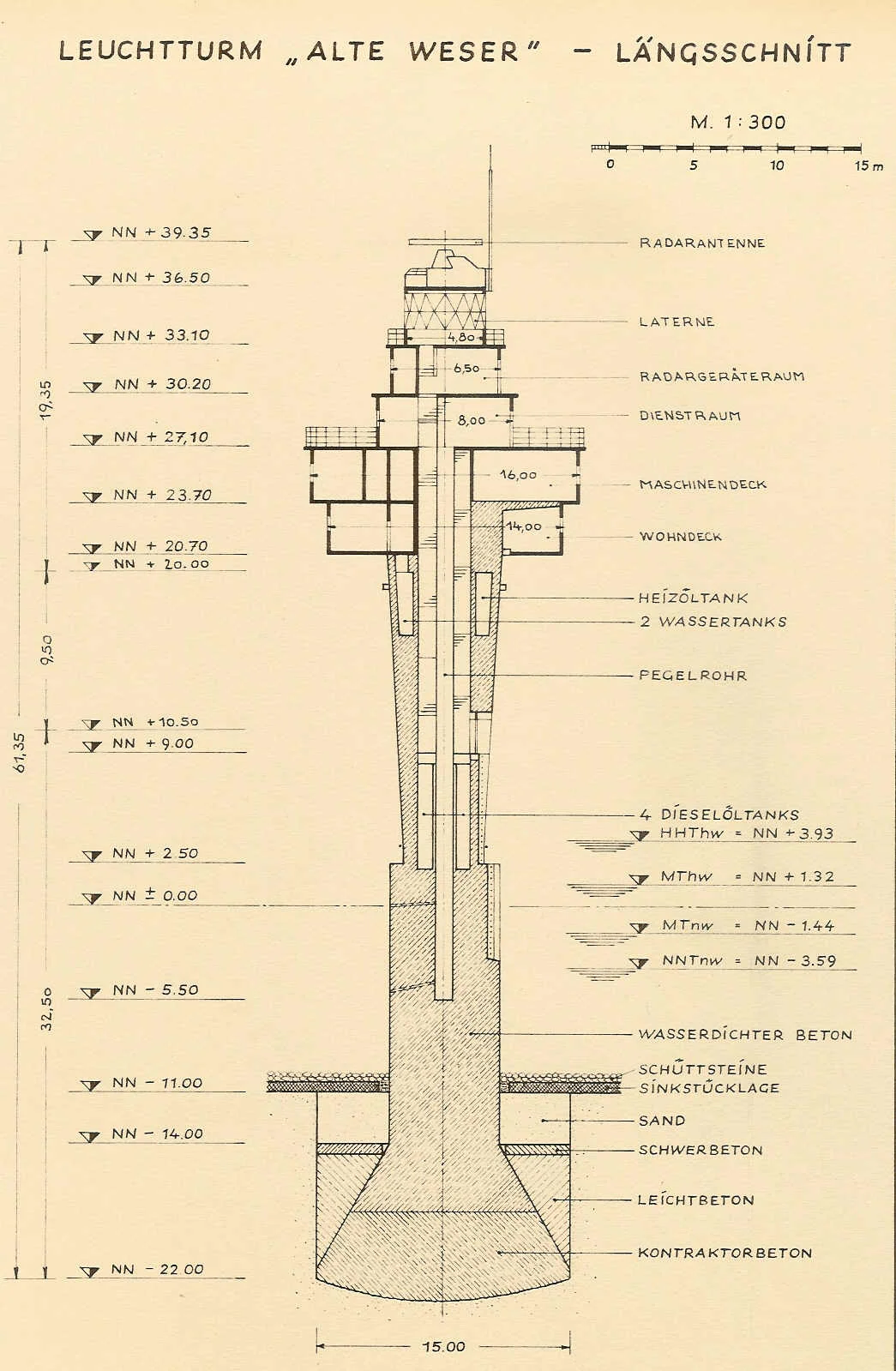
Engineer Andreas Carstens of Bremerhaven had a simple, almost counterintuitive idea. To resist the North Sea, the tower should narrow toward the bottom, not the top. A cone wide at the head and tapering downward gives the waves and the drift ice less to grab and shove. So the Alte Weser Lighthouse, when it finally went into service in 1964 after two accidents and a year-long delay, looked like nothing else on the German coast: a forty-meter spike of steel-coated ferroconcrete with cantilevered upper storeys hanging out over the water, the whole thing jetted eleven meters down into a sandbed off the mouth of the river Weser. The design was strange enough to land on a postage stamp twelve years later.
Why the Old One Had to Go
The lighthouse it replaced, Roter Sand, had stood in the outer Weser waterway since 1885. By the late 1950s the concrete was leaching, the steel was corroding, and the structure - one of the first offshore lighthouses anywhere in the world to be built directly on sand - was clearly failing. At the same time, the German Waterway Administration wanted to deepen and modernize the approach to Bremen and Bremerhaven, and a new offshore station would do double duty as a navigation aid and as a node in the planned radar chain. Roter Sand could not be patched into either role. So in 1961, engineers began building its successor a short distance away, while Roter Sand itself was eventually preserved as a historic monument.
Two Accidents, One Year Lost
Construction did not go smoothly. The first attempt placed the tower shaft on its sand foundation, lowered it, and began jetting it down to depth - and then a sudden, unexplained leak killed two workers. The exact cause was never determined. The shaft had to be abandoned. Its upper storeys were detached and shipped back to Kiel on a floating lift platform; the old stump remains buried under the seabed today. A year was lost to starting over. Then the lift platform itself failed - a malfunction in the gripper at one of its front legs - and a second platform had to be brought in to retrieve the first. Through all of this, the catastrophic 1962 storm surge that killed hundreds in Hamburg and along the coast somehow spared the construction site. In the third year, the work finally resumed, and the cone of the new tower was jetted into the sand. The upper storeys, still waiting in Kiel, were placed on top in calm weather, without complication.
The Light Itself
The optic at the top emits a continuous beam from a 2,000-watt Xenon lamp. Depending on the bearing from which a ship sees it, the color changes - white, red, or green - which lets a captain know, without a single instruction, exactly where in the approach channel he is. In fog, a horn sounds the Morse-code letters AL once a minute. Around the lantern hang the rest of the tower's instruments: directional antennas, a radar, an anemometer measuring wind, a tide gauge measuring water, an emergency generator in case the cable from Robbenplate fails. Until 1972 four keepers lived in the cantilevered storeys, watching their banks of dials and waiting out the gales. After automation, the rooms became accommodation for the maintenance crews who service the systems.
Visible from Only One Place
There is a peculiar geographical fact about the Alte Weser. Of all the inhabited places in northwestern Germany, only one offers a view of the lighthouse with the naked eye: the East Frisian island of Wangerooge, about 25 kilometers to the west across open water and tidal flats. From anywhere else on land the curvature of the Earth, or weather, or another sandbank, gets in the way. The light was built for ships, not for people, and it shows. Two years after Alte Weser went live, a companion tower - the all-steel Tegeler Plate Lighthouse - was jetted into a nearby sandbar in a single step, drawing its power from the same submarine cable. Together they replaced an old lightship called Bremen and remade the approach to the Weser. The Tegeler Plate ran unmanned from day one. Alte Weser still has, on a fine day, a window someone occasionally opens.
From the Air
The Alte Weser Lighthouse stands at 53.86°N, 8.13°E in the outer Weser waterway of the German Bight, offshore from the river mouth between Bremerhaven and the East Frisian Islands. Look for a distinctive downward-tapering conical tower roughly 40 m tall, surrounded by tidal sandbanks. The companion Tegeler Plate Lighthouse, a slimmer all-steel structure, lies a short distance to the south. Bremerhaven (Nordholz - Cuxhaven airbase ETMN to the east) is the nearest mainland reference, with Wilhelmshaven (Mariensiel EDWI) to the west. The lighthouse is the only one in the area visible from the inhabited island of Wangerooge, about 25 km west. Recommended viewing altitude 1,500-2,500 feet for the cone's silhouette against the Wadden Sea.
Nearby Stories
- German Trawler V 1101 Preussen 6.6 km away
- JadeWeserPort 8.4 km away
- Taktisches Luftwaffengeschwader 71 "Richthofen" 8.5 km away
- SM UC-45 9.9 km away
- HMS Ariel (1911) 13 km away
- Wöbbelin Concentration Camp 181 km away
- Ludwigslust Palace 188 km away
- Lilleø 194 km away