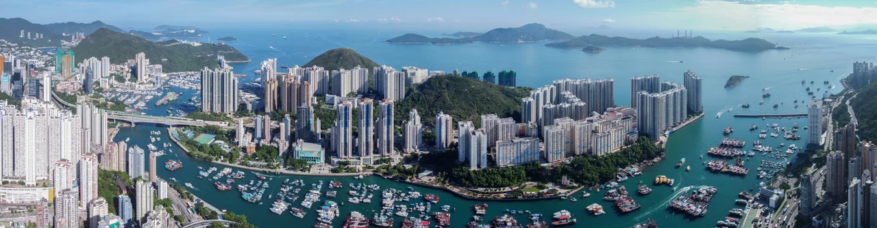

Ap Lei Chau
The island is shaped like a duck's tongue. Ap means duck, lei means tongue, chau means island — and once you know the etymology, the Cantonese name becomes both precise and oddly affectionate. Before the British arrived, before anyone counted populations or built tower blocks, Ap Lei Chau was a small fishing village whose natural harbour provided shelter from typhoons and whose settlements appeared on Ming-era maps as "Fragrant Harbour Village." That Cantonese phrase — hēung góng — is the probable origin of Hong Kong's name, though the town eventually took the name of the island it faced. The island kept its duck tongue.
The Island That Named a City
The connection between Ap Lei Chau and the name Hong Kong runs through linguistic history. The island's early settlement, called Fragrant Harbour Village, used the Cantonese phrase hēung góng, which translates variously as "fragrant harbour" or "incense harbour" — likely a reference to the fragrant wood or incense traded along these shores. When British ships surveyed these waters before the First Opium War, they heard the name applied to this small island and its settlement. It transferred, through the usual imprecision of colonial cartography, to the harbour between the island and the mainland, and from there to the whole territory. The 1842 Treaty of Nanking that ceded "Hong Kong Island" to Britain was therefore, in a sense, a document about a place named after a duck-tongue island's fishing village. Ap Lei Chau itself went on to live a quieter history under British rule until the second half of the twentieth century.
Towers on a Duck's Tongue
In the 2000s, Guinness World Records listed Ap Lei Chau as the world's most densely populated island. The numbers support the claim: a population of 79,727 people living on 1.30 square kilometres after land reclamation. That's not density as an abstraction — it's the physical reality of multiple clusters of high-rise residential towers packed onto a small landmass, with very little horizontal space between them and the water. The northern part of the island holds the highest concentration of people, spread across four main residential areas: Lei Tung Estate, Ap Lei Chau Main Street, South Horizons, and Ap Lei Chau Estate. Each comprises several tower blocks. Public space is the island's chronic shortage: when the government sold a former driving school site on Lee Nam Road for luxury apartment development in 2016, residents objected that it should have become a park. The land sold in 2017 for a record HK$16.86 billion.
Power Station to Residential District
In 1968, Hongkong Electric opened a power station on Ap Lei Chau to supply electricity to the whole of Hong Kong Island. The station ran for two decades before the generators were relocated to Lamma Island in 1989. The old station site, combined with land reclaimed from the sea, became the South Horizons residential development — towers rising on what had been industrial ground. The transformation is visible in Ap Lei Chau's patchwork character: the industrial estate still operates on the island's southern tip, while the residential towers crowd the northern and central areas, and the MTR South Island line, opened 28 December 2016, connects the island to Hong Kong Island proper via two stations, Lei Tung and South Horizons. Before the MTR and before the bridges, sampans were the primary link to Aberdeen, a connection that still runs regularly between Main Street and the harbour.
Temples That Watch the Harbour
Not everything on the island was built in the last century. The Hung Shing Temple on Hung Shing Street dates to 1773, making it the oldest temple in the Aberdeen and Ap Lei Chau areas and a declared monument. Hung Shing is a deity associated with the sea and good weather — appropriate for a community of fishermen who depended on both. Nearby, the Shui Yuet Temple on Main Street, built at the end of the nineteenth century, is dedicated to Kwun Yum, the goddess of mercy, and also houses Kwan Tai, Tin Hau, Chai Kung, and Wong Tai Sin. The temple sits adjacent to the site of the former Aberdeen Police Station. When it was built, the placement was deliberate — the temple's feng shui position was chosen specifically so that the superior dragons it housed would protect the community from the "tiger's jaw" of the police station beside it. The police station is gone. The dragons remain.
From the Air
Ap Lei Chau sits at approximately 22.242°N, 114.156°E, directly south of Aberdeen across the typhoon shelter channel. From the air, it is unmistakable: a compact, heavily built-up island separated from Hong Kong Island by a narrow channel, with the Ap Lei Chau Bridge visible as a road link crossing the gap. The island's highest point, Yuk Kwai Shan (Mount Johnston) at 196 metres, forms a green ridge on the south side contrasting with the tower density to the north. At 2,000 to 3,500 feet, the island's outline and the channel separating it from Hong Kong Island are clearly visible. Hong Kong International Airport (VHHH) is approximately 20 nautical miles to the northwest. Lamma Island lies to the southwest and is visible on clear days.
Nearby Stories
- Lok Ma Chau Loop 2.3 km away
- Portas do Cerco 2.3 km away
- Kweilin Incident 17 km away
- Wanshan Archipelago Campaign 34 km away
- Nanxiong Formation 115 km away
- Battle of Nanpeng Island 148 km away
- Heyuan 169 km away
- Cape Maobitou 632 km away