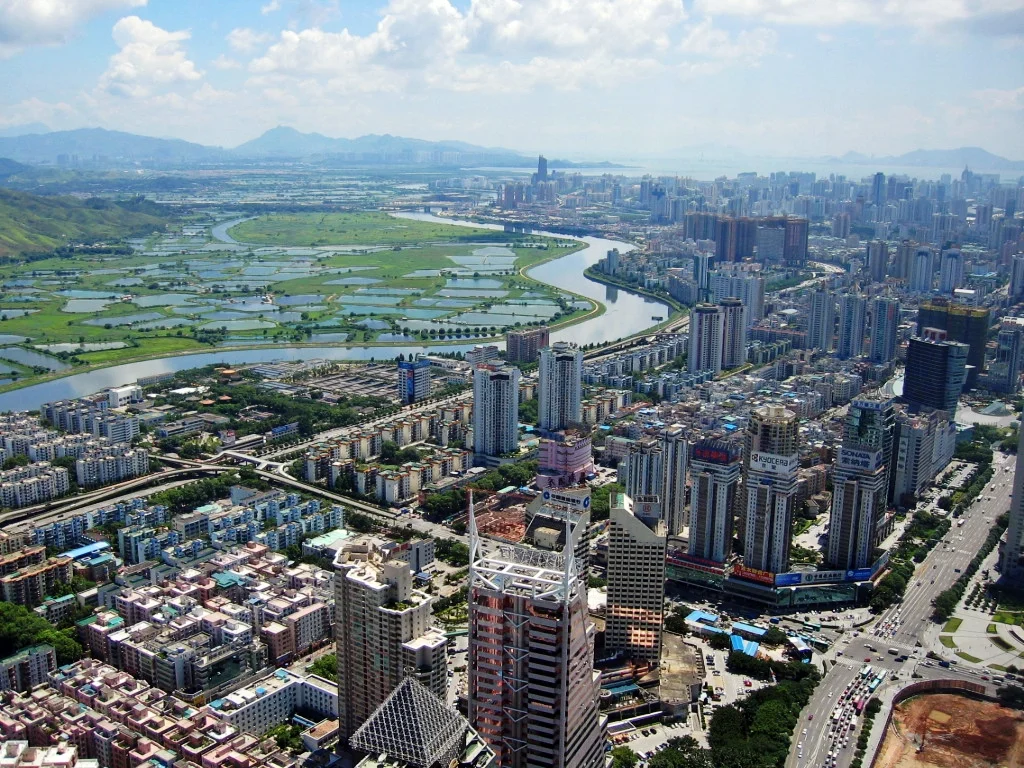

Lok Ma Chau Loop
A river made the Lok Ma Chau Loop. Or rather, engineers straightening a river made it. Until the late 1990s, the piece of land now called the Loop was unambiguously part of mainland China. Then the governments of Hong Kong and Shenzhen undertook works to straighten the winding course of the Sham Chun River — the waterway that forms the natural boundary between the two jurisdictions. When the river's new, straighter channel was complete, the natural border had moved north, and a small parcel of land was suddenly accessible only from the Hong Kong side. The border had shifted without anyone intending to create a political anomaly. What followed was years of territorial dispute, a technology park proposal, a COVID isolation facility, and an ongoing argument about whether the place should be a research hub, a real estate play, or a wetland.
A Border Moved by Engineering
The Sham Chun River has been actively managed for decades. In 1995, Hong Kong and Shenzhen jointly completed environmental impact studies for the first phase of river improvement works — straightening approximately 3.2 kilometers of meandering channel near Lok Ma Chau and Liu Pok to reduce flooding and improve water quality. The unintended consequence of this practical engineering was geographical. The Loop — a roughly oval parcel of 0.97 square kilometers — found itself cut off from mainland China by the new river alignment, reachable only from Hong Kong. Technically it remained Chinese territory; practically, it was an island in a foreign jurisdiction. The dispute over sovereignty took years to resolve, and was ultimately settled not through a formal boundary adjustment but through the announcement of a joint development project: the Hong Kong-Shenzhen Innovation and Technology Park. The agreement to develop the Loop together made the question of who owned it answerable — both, in a sense, through the technology park — and in January 2017 the Loop was formally transferred to Hong Kong.
The Only Unincorporated Land in Hong Kong
For years after the transfer, the Lok Ma Chau Loop occupied a peculiar constitutional position. With an area of 0.97 km², it was the only unincorporated territory in Hong Kong — not formally part of any of the territory's 18 administrative districts. It was also, by extension, the only unincorporated land under the People's Republic of China, since Chinese administrative law requires every parcel to belong to a county-level administrative division. Legislative Council member Eddie Chu raised the question formally in March 2019, asking authorities to incorporate the Loop into one of Hong Kong's existing districts. The answer came in June 2025, when the Hong Kong government gazetted the Loop's inclusion in the New Territories North constituency, and submitted the proposal to the Legislative Council. Once that process is complete, the Loop will cease to be the anomaly it has been since the river moved — fully integrated into Hong Kong's administrative structure for the first time.
A Technology Park with a Complicated Argument
The Hong Kong-Shenzhen Innovation and Technology Park was announced with considerable ambition: 87 hectares of cross-border development space, expected to provide 1.2 million square meters of office space for companies from both cities, intended to position the Pearl River Delta region as a global technology hub. The joint ceremony marking the announcement took place on January 3, 2017. The criticisms followed quickly. Environmental groups pointed to the site's ecological value — it sits within a migratory bird flight path, adjacent to wetland systems that connect to Deep Bay, the Hong Kong Wetland Park, and the Mai Po Marshes. Estimates suggested the development would cost the area 4,000 trees, 11 hectares of reed marsh, and 9 hectares of ponds. Questions arose about contaminated mud beneath the site. And observers noted that Hong Kong had already built two high-profile technology parks — Cyberport and Science Park — both conceived after the 1997 Asian financial crisis, both slow to achieve their ambitions. Whether the Loop's park would avoid those precedents remained unanswered as planning continued.
The Pandemic Interlude
Before the technology park broke ground, the Loop served a different purpose. During the COVID-19 surge driven by the Omicron variant in early 2022, the site was rapidly converted into an isolation and treatment facility. A temporary bridge connecting the Loop to Shenzhen was erected to allow workers and construction materials to flow freely across the border — an irony given that the Loop's entire history had been defined by border disputes. The facility was planned to provide 50,000 beds, staffed by care workers from mainland China. The speed of construction and the scale of the response demonstrated both what the site's blank-slate character made possible and the degree to which Hong Kong-mainland cooperation could be mobilized under emergency conditions. The pandemic facility was temporary. The technology park moved forward: the Hong Kong-Shenzhen Innovation and Technology Park was inaugurated on 22 December 2025, with three of the eight planned first-phase building complexes — two laboratories and an accommodation block — completed and more than 80 percent of laboratory floor space already leased.
From the Air
The Lok Ma Chau Loop sits at approximately 22.52°N, 114.08°E, directly adjacent to the Sham Chun River on the western section of the Hong Kong–Shenzhen border, between the Lok Ma Chau border crossing to the south and Shenzhen's Futian district to the north. From the air, the Loop is visible as an oval of relatively open, low-lying land surrounded by the river to the north and west — distinctly greener than the dense development of Shenzhen's Futian district immediately adjacent. The Lok Ma Chau immigration control point and its road infrastructure are visible to the south. The Mai Po Marshes and Deep Bay lie to the west. This site straddles the zone covered by both Hong Kong International Airport (VHHH, approximately 35 km to the southwest) and Shenzhen Bao'an International Airport (ZGSZ, approximately 30 km to the west). Best viewed at 3,000–5,000 feet to appreciate both the riverside geography and the contrast between the Loop's open ground and the surrounding urban fabric.
Nearby Stories
- Hong Kong Disneyland 4.1 km away
- Mount Guanyin (Dongguan) 7 km away
- 2024 Lixinsha Bridge Collapse 7.4 km away
- Portas do Cerco 12 km away
- Lotus Hill 15 km away
- Nanxiong Formation 78 km away
- Heyuan 130 km away
- Checheng Fu'an Temple 629 km away