Aparecida de Goiânia
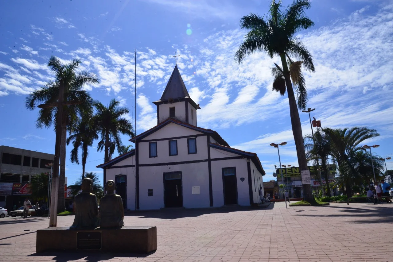
In 1922, a group of devotees of Our Lady of Aparecida - Brazil's patron saint, a small black terracotta Virgin pulled from a river by three fishermen in 1717 - decided their neighbors needed a proper chapel. They donated land on the southern edge of the recently planned state capital. A hundred years later, that chapel sits at the heart of a city of nearly 600,000 people, the second largest in Goiás, with 964 industries lining the BR-153 highway and the population growing faster than nearly any other city in the state. Aparecida de Goiânia was never supposed to be this big. It pulled it off anyway.
A Chapel on the Edge
The math on Goiânia is worth understanding before anything else. The state capital was only founded in 1933 - a planned city built to replace the colonial-era capital, Vila Boa. Aparecida's founding gift in 1922 therefore predated the capital it would eventually become a suburb of. The region remained sparsely settled for decades. In 1958 the community was elevated to vila - essentially a municipal status - as a district of Goiânia. The name at that point was Aparecida de Goiás. In the same year it switched again, this time to Goialândia. That lasted until 1963, when the community finally got its independence from Goiânia and chose a third name: Aparecida de Goiânia, anchoring the town's identity both to its patron saint and to the capital it had hoped to escape.
A Suburb That Grew Up
The population numbers read like a time-lapse sped up too fast. In 1980 the city had 42,000 people. By 2007 that number had jumped past 400,000. The 2020 estimate put it at 590,146. Population growth between 2000 and 2007 averaged 5.06 percent per year - remarkable for a Brazilian city in that period and well above state averages. The explanation is simple enough. Goiânia's center lies 21 kilometers to the north, and housing in the capital kept getting more expensive. Aparecida offered cheaper homes, lots, and rentals close enough that workers could commute. Density now sits at 1,647 inhabitants per square kilometer, one of the higher figures in the Central-West. The Meia Ponte River cuts through the city, separating neighborhoods and providing what greenery there is.
The Industrial Spine
What really turned Aparecida from dormitory into city was industry. Four distinct industrial zones line the BR-153, the Goiânia-São Paulo highway that bisects the municipality. DAIAG - the Distrito Agroindustrial de Aparecida de Goiânia - anchors one of them. Dimag anchors another. Pólo Empresarial Goiás and Cidade Empresarial complete the set. Mabel, the cookie manufacturer, set up major operations here. Vepeza followed. By 2007 the municipality counted 964 industries, a number that had doubled in just a few years. The city became Goiás's third-largest industrial center, with a 2018 GDP of 11.98 billion reais - trailing only Goiânia and Anápolis. Thirteen financial institutions had branches in the city by 2007.
What Survived the Boom
Despite the industrialization, agriculture did not entirely disappear. The cattle herd was 11,700 in 2003. Farmers still produce rice, manioc, bananas, coconut, and sugarcane on land that has not yet been swallowed by subdivisions or factories. The climate helps: tropical savanna, rainfall around 1,500 millimeters concentrated in November through March, annual mean temperature around 21 degrees Celsius. The festival of the city's patroness, Nossa Senhora Aparecida, still draws Catholic pilgrims and remains the most significant tourist event on the calendar - a connection back to the 1922 land donation that started everything. The contrast between the chapel and the Hyundai billboards along BR-153 is the whole story in one image.
Living Next to the Capital
Aparecida ranks 49th out of 242 Goiás municipalities on the human development index. Literacy rose from 85.2 percent in 1991 to 92.1 percent in 2000. Infant mortality dropped from 35.4 per 1,000 live births in 1990 to 20.9 in 2000 - the kind of steady improvement that reflects expanding hospital infrastructure and a growing middle class. Eight hospitals with 782 beds now serve the city. Six universities and colleges operate here, including the State University of Goiás and the Faculdade Alfredo Nasser. In October 2008 Maguito Vilela was elected mayor and took office the following January. Aparecida had 224,835 eligible voters by then - more than most entire cities in Goiás. For a place whose founding story is about religious pilgrims donating land for a chapel, Aparecida has become something very different, but the original faith - and its festival - still pull crowds through town each October.
From the Air
Coordinates 16.82°S, 49.24°W, elevation roughly 750-800 m on the central Brazilian plateau. Recommended viewing altitude 3,000-5,000 ft AGL to appreciate the industrial corridor along BR-153 and the contiguous urban area merging into Goiânia to the north. Nearest major airport is Santa Genoveva Airport (SBGO) in Goiânia, 21 km north. The Meia Ponte River provides a useful ground reference cutting through the city. Expect substantial urban traffic and industrial haze; best visibility during the cerrado dry season (May-September).
Nearby Stories
- Anicuns 8.2 km away
- Nerópolis 23 km away
- Silvânia 31 km away
- São Luís de Montes Belos 56 km away
- Alexânia 62 km away
- Pires do Rio 68 km away
- Morrinhos, Goiás 82 km away
- Rio Verde, Goiás 135 km away