
Arlington County, Virginia
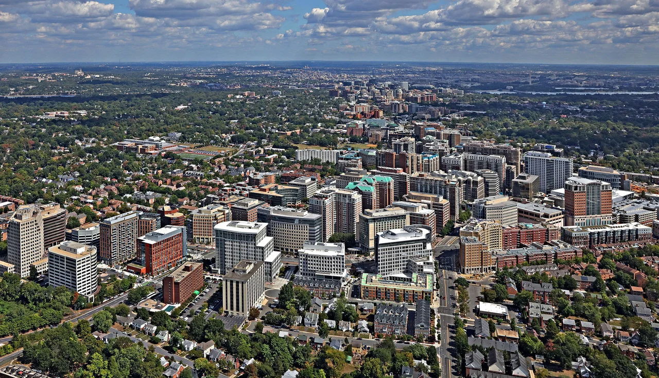
Arlington County is small enough to walk across. At 26 square miles, it is the smallest self-governing county in the United States by area. It contains, in that small space, the Pentagon, Arlington National Cemetery, the Marine Corps War Memorial, Ronald Reagan Washington National Airport, the southern half of three Potomac River bridges, the headquarters of Amazon's second headquarters, several billion dollars of federal contracting offices, two major Metro corridors, a two-century-old plantation house that became the cemetery, and about 240,000 residents whose median household income is among the highest in the country. There is no city government in Arlington. The whole county functions as a unified jurisdiction governed by a five-member board. Most of it was originally part of Washington, D.C. - which is why it has the same name as the cemetery and the same street grid as the capital across the river.
The Retroceded Square
When Congress established the District of Columbia in 1790, the federal district included a sizable chunk of Virginia on the south bank of the Potomac. The Virginia portion - what is now Arlington County and the City of Alexandria - had been part of Fairfax County since 1742. From 1801 it was called Alexandria County, D.C. The townspeople of Alexandria and the planters of the country part were both unhappy with their federal status: Congress provided little infrastructure investment, Alexandria's debts from the Alexandria Canal grew enormous, and the residents had no congressional representation. In an 1846 county-wide referendum, the residents voted to leave D.C. and rejoin Virginia. Congress approved. In 1847 the retrocession was complete. Alexandria County remained part of Virginia thereafter, and in 1920 the country part - the rural portion outside the City of Alexandria - was renamed Arlington County, after the plantation house where Robert E. Lee had lived before the Civil War. The plantation grounds were already a federal cemetery.
From Plantation to Cemetery
George Washington Parke Custis - George Washington's step-grandson - inherited 18,000 acres and built Arlington House on the heights above the Potomac in the early 1800s. He owned about 200 enslaved people across his Virginia properties. When his daughter Mary Anna Custis married Robert E. Lee in 1831, the Arlington estate passed eventually to her. When Virginia seceded and Lee resigned his U.S. Army commission to lead the Confederate army, the federal government seized the estate for unpaid property taxes. In 1864 Quartermaster General Montgomery Meigs - whose son had been killed in the war and who was furious at Lee for what he saw as treason - ordered Union dead to be buried in Mary Lee's flower garden, ensuring the house could never be reoccupied as a home. The cemetery began with 65 graves in 1864. By war's end there were 16,000. Today Arlington National Cemetery holds the remains of more than 400,000 service members and their dependents, including John F. Kennedy under the eternal flame, the Unknown Soldiers, and most of those killed in nearly every American war since the Civil War. About 3 million people visit each year. Arlington House, restored as a memorial, still stands at the top of the hill.
Desegregation Before Massive Resistance Lost
Arlington County in the 1950s was Virginia. It had Jim Crow segregation laws like the rest of the state, racially separate schools, and Senator Harry F. Byrd's Massive Resistance campaign actively opposed integration even after Brown v. Board of Education ordered it. In Arlington, however, the federal employees who increasingly made up the population were less politically rooted in Virginia's segregationist tradition than the longtime planter and farmer class. A federal court ruled Virginia's school placement law unconstitutional in January 1959. On February 2, 1959 - the same day Norfolk integrated - four Black students walked into Stratford Junior High in Arlington under heavy police protection. Arlington became the first county in Virginia to desegregate its public schools. The next year, Black students led sit-ins at lunch counters along Lee Highway and along the Wilson Boulevard corridor, and by June 1960, Arlington was the first county in Virginia to desegregate its businesses. The Arlington Cinema 'N' Drafthouse on Columbia Pike was forced open in 1963 after Dorothy Hamm's lawsuit. Arlington had been first in Virginia because Arlington had become a federal town.
The Metro Corridors
The decisions that defined modern Arlington were made in the 1960s and 1970s, when the county government insisted that the new Washington Metrorail system put its Orange and Silver Line stations directly under the urban corridors of Rosslyn, Court House, Clarendon, Virginia Square, and Ballston - rather than along the more convenient Interstate 66 right-of-way. The county then rezoned the corridor for high-density mixed use immediately around each station, with strict height limits a few blocks away to protect adjacent single-family neighborhoods. The result is sometimes called the Arlington Way - transit-oriented development decades before the term was coined. The Rosslyn-Ballston corridor today is the densest urban office market in northern Virginia. Crystal City, immediately south, hosts the new HQ2 of Amazon, announced in November 2018 and now home to roughly 8,500 employees. About 70 percent of all jobs in the county are concentrated in these planning corridors. Outside the corridors, single-family neighborhoods of bungalows and Colonials remain mostly intact. The contrast is intentional - and contested, as Arlington's housing prices have made the single-family rule increasingly controversial. A 2023 zoning change cautiously permitted small multifamily buildings on previously single-family lots. The board members who supported it have been replaced. The argument continues.
From the Air
Arlington County spans roughly 38.83 to 38.91 degrees N and 77.04 to 77.17 degrees W on the southwest bank of the Potomac, directly across from Washington, D.C. The county is bisected by Interstates 66 and 395, the George Washington Memorial Parkway along the river, and the Metro Orange/Silver and Blue/Yellow line corridors. Ronald Reagan National (KDCA) sits in the southeast corner. The entire county is inside Class B airspace and the Washington Special Flight Rules Area. P-56A over the Capitol and P-56B over the Pentagon dominate the eastern side. Coordinate with Potomac TRACON. Watch for DCA approach and departure corridors.
Nearby Stories
- Gunston Hall 1.1 km away
- 2023 Baltimore Shooting 4.9 km away
- Battle of Middleburg 6.6 km away
- Crownsville Hospital Center 10 km away
- Battle of Loudoun Heights 13 km away
- First Battle of Rappahannock Station 20 km away
- Howard County, Maryland 21 km away
- Harriet Tubman Underground Railroad 50 km away