Asir
The diurnal temperature range in the highlands of Asir is among the greatest in the world. Afternoons climb past 30 degrees Celsius; mornings freeze. Fog cuts visibility to near zero. Coniferous forests - actual coniferous forests, in Saudi Arabia - cling to sheltered slopes where the moisture collects. This is the country's wettest, coolest, and most vertically dramatic province, and it was also one of the last territories to accept Saudi rule. The Asiris did not surrender easily. They fought the Ottoman Egyptian forces in 1818 after the First Saudi State fell. They fought the Ottomans themselves in the 1870s. They fought the Idrisis and then the Hashemites. Asir was an internationally recognized sovereign state into the 1920s - and it is still, in many quiet ways, a place that does things its own way.
Where the Sarawat Peaks
The province sits on a high plateau in southwestern Saudi Arabia, bounded by Mecca Province to the north and west, Al-Bahah to the northwest, Riyadh Province to the northeast, Najran Province to the southeast, and Yemen's Saada Governorate to the south. Covering 76,693 square kilometers, it holds roughly 2 million people as of 2022. The capital is Abha, the largest city is Khamis Mushait, and the crown of the province is Jabal Soudah, rising to 3,015 meters near Abha - the highest peak in Saudi Arabia. The average annual rainfall in the highlands reaches 300 millimeters or more, falling mostly in March and April with some summer rain. Asir National Park, established in 1981, sweeps from the Red Sea coast through the western foothills and up the escarpment. Agriculture clings to the slopes: wheat, fruit, and - historically - coffee, senna, and frankincense. Villages wove tents from straw. The high plateau has always been, by Saudi Arabian standards, a green country.
The Emirate That Almost Was
When the First Saudi state was destroyed by the Ottoman Empire in 1818, the Asiris refused to accept Ottoman rule. They fought. With the Ottoman withdrawal in 1840, the Al-Ayedh dynasty took control of the highlands. They aligned with the Saudis - who had by then re-established themselves - without formally submitting. When the Al-Ayedh tried to expand into the Tihamah lowlands, the Ottomans returned, defeated and executed the Al-Ayedh leader in 1872, and tried to rule Asir through a sub-governorate attached to the Yemen vilayet. Their rule rarely extended beyond the walls of their forts. In about 1906, Muhammad ibn Ali al-Idrisi, a descendant of the Sufi scholar Ahmad ibn Idris al-Fasi, began consolidating political control. He negotiated with Italy, fought the Ottomans, was defeated by the Hashemites in 1911, then signed a secret military alliance with Britain in 1915. After World War I he was ruler of an internationally recognized state - the Emirate of Asir - reaching from Abha in the north to Hodeidah in the south, until his death in 1920. His successors could not hold it together. Ibn Saud took Abha in 1920, and the rest of Asir by 1923. In 1935 it was reorganized as a separate governorate of Saudi Arabia.
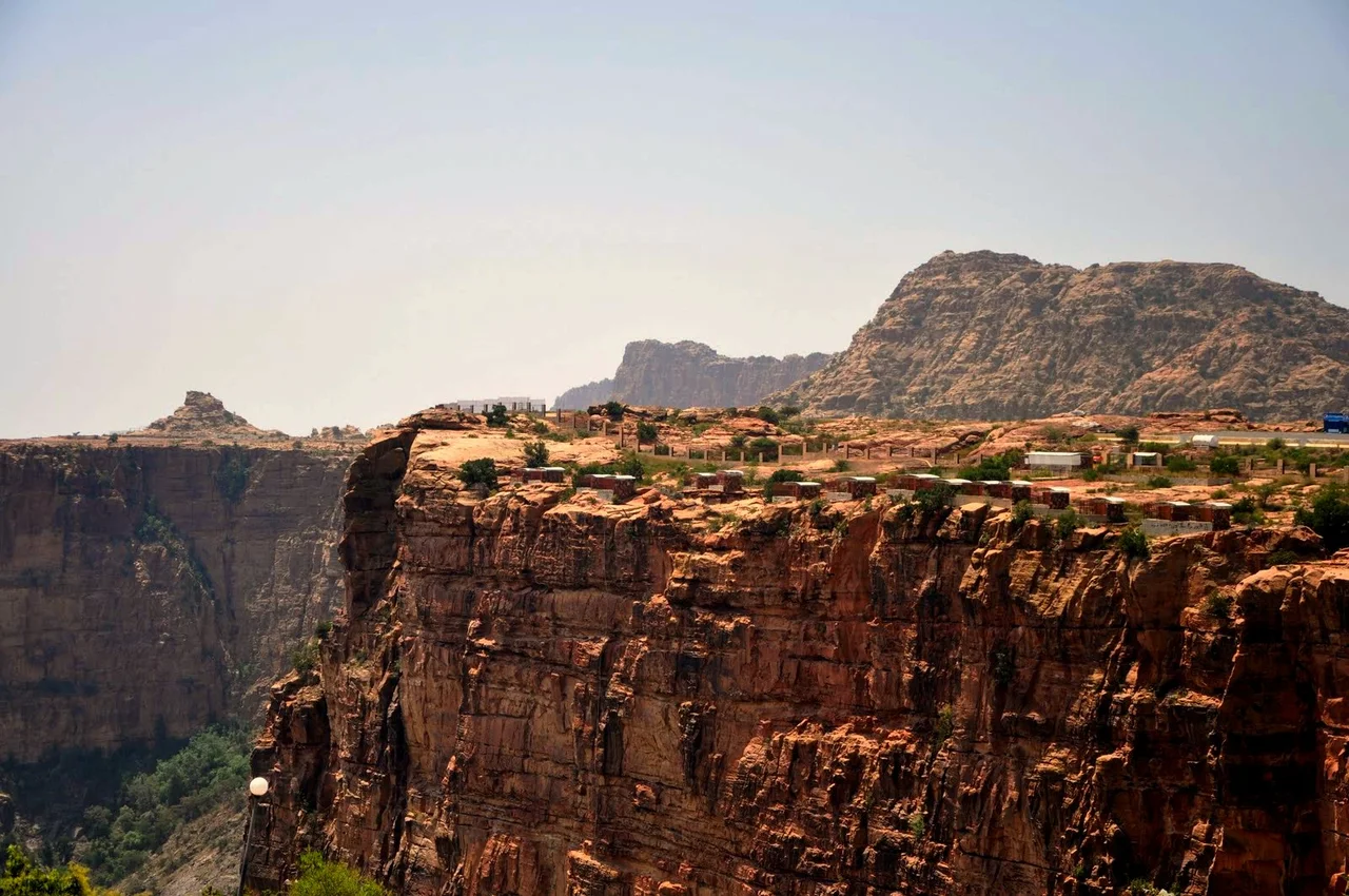
The Vertical Garden
Traditional Asiri houses are stone towers painted on the inside with geometric designs in vivid colors - a women's art form called al-Qatt al-Asiri, recognized by UNESCO in 2017. The paintings cover interior walls in red, yellow, green, and black, the patterns passed down matrilineally and applied fresh at weddings and births. Outside, the villages step down mountainsides in terraces, some of them centuries old. Jabal Soudah, near Abha, draws visitors in summer from across the kingdom: the cable car, the mountain air, the juniper woods that survive here and almost nowhere else in Saudi Arabia. Habala Valley once housed a community accessible only by rope - its people called the Hanging People, the houses stacked on ledges hundreds of meters below the clifftop. The road and cable car arrived later. Many residents relocated. The empty houses remain.
Soudah Peaks and the Future
Since 2019, the Saudi government has poured more than a billion riyals into the province's infrastructure - health care, transportation, municipal services - as part of Vision 2030's push to diversify the economy away from oil. The headline project is Soudah Peaks, a planned luxury mountain resort at 3,015 meters above sea level, announced as one of Saudi Arabia's premier tourism destinations. The Asir Development Authority has outlined cable car networks, improved connections between airports and tourist sites, and environmental protections meant to preserve what makes the province unique in the first place. King Khalid University, established in 1998 through the merger of satellite campuses from two older universities, anchors higher education. The province is changing quickly. Whether its traditional villages and terraced fields survive the transformation is a question the next decade will answer.
The Border Nobody Talks About
Asir shares a long border with Yemen, and that border has a grim recent history. Since 2014, hundreds of Ethiopian migrants attempting to cross from Yemen into Saudi Arabia through Asir have been killed. A 2023 Human Rights Watch report documented at least several hundred deaths between March 2022 and June 2023, with patterns the report called widespread and systematic. Women have reported rape. The deaths fall on people who left East Africa seeking work, traveled across Yemen's war, and met Saudi border guards at the last stretch of a journey that was supposed to change their families' lives. These are not the people the tourism brochures mention. They deserve to be remembered in any honest description of the province - alongside the mountains, the paintings, the forests, and the old emirate that once ruled here.
From the Air
Asir Province spans southwestern Saudi Arabia centered near 19.00 N, 43.00 E. The Sarawat escarpment includes Jabal Soudah near Abha, at approximately 2,990 m, the highest peak in Saudi Arabia. Abha International Airport (OEAB) is the primary airfield. Expect severe terrain with rapid altitude changes, orographic cloud on the western escarpment, and extreme diurnal temperature swings. Morning fog is common in the highlands. Winter visibility can drop sharply with thunderstorms coming off the Red Sea. The Yemen border to the south and east has sensitive airspace - verify current restrictions. Highway 10 connects Abha eastward to Najran.
Nearby Stories
- Dhorm Mountain 43 km away
- Bareq 65 km away
- Shadah Al-asfal 129 km away
- Al-Okhdood 157 km away
- Jazan Province 157 km away
- Qaryat al-Faw 171 km away
- Al-Baha Province 180 km away
- Houthi–Saudi Arabian conflict 185 km away