The River That Connects Borneo to Madagascar
Somewhere around the seventh century, people from the interior of Borneo boarded boats and sailed west. They crossed the Indian Ocean, a journey of some 7,000 kilometers, and settled on an island off the east coast of Africa. Today, the language spoken by 25 million people on Madagascar traces roughly 90 percent of its vocabulary to a tongue still spoken by about 70,000 Ma'anyan Dayaks living along the banks of a single river in southeastern Borneo. That river is the Barito, and it is one of the more quietly astonishing places on Earth -- not for what it looks like, though it is striking, but for what it set in motion.
A River Through the Heart of Borneo
The Barito stretches 1,090 kilometers from the Muller Mountain Range in the deep interior of Borneo southward to the Java Sea, making it the island's second longest river after the Kapuas. Its drainage basin covers more than 80,000 square kilometers of South and Central Kalimantan, an expanse of tropical rainforest, peat swamp, and floodplain that has shaped the ecology and human settlement of southeastern Borneo for millennia. The river is wide enough in its lower reaches to carry oceangoing vessels, and at its mouth near Banjarmasin it fans into a broad delta laced with tributaries. The Negara and Martapura rivers join it from the east, their confluences creating the watery crossroads where the city of Banjarmasin -- the 'City of a Thousand Rivers' -- took root in 1526.
The Crossing No One Expected
Linguists in the nineteenth century noticed something strange: the Malagasy language of Madagascar bore no resemblance to the Bantu languages of nearby mainland Africa. Instead, it belonged to the Austronesian family, the same group that includes Malay, Javanese, and Tagalog. Further analysis narrowed the connection to the Greater Barito East subgroup, and specifically to the Ma'anyan language spoken by Dayak communities along the upper Barito River. How did an inland people without seafaring traditions cross the Indian Ocean? The prevailing theory holds that Malay traders, who had established trading posts in southeastern Borneo, brought Ma'anyan people as subordinates or trading partners on voyages westward, probably around 650 CE. The result was one of the longest maritime migrations in pre-modern history, and it left the Barito River valley as the unlikely linguistic motherland of an island nation 7,000 kilometers away.
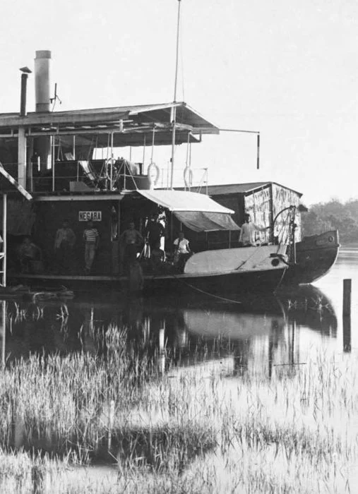
Timber Rafts and Colonial Ambitions
Long before linguists traced those connections, the Barito was a highway of commerce. Dayak communities traded forest products -- rattan, resin, and rare woods -- downstream to coastal markets. When the Dutch East India Company arrived in the seventeenth century, the river became a conduit for colonial extraction. Carl Schwaner's 1844 expedition up the Barito led to the discovery of coal deposits at Riam Kiwa, opening the first coal mines in the Dutch East Indies. Timber rafts, some large enough to carry workers' housing on their decks, floated downriver to the coast. Early twentieth-century photographs from the Tropenmuseum show these floating platforms drifting past jungle banks, a paddlewheel steamer chugging alongside -- the industrial age arriving by water in one of the most remote landscapes on the planet.
The Living River
The Barito basin sits within a tropical rainforest climate zone, warm and wet year-round. October is the warmest month; December the wettest. The river sustains one of Borneo's most biodiverse corridors, its banks home to proboscis monkeys, freshwater dolphins, and dense stands of ironwood and meranti. But the same qualities that make it ecologically rich also make it vulnerable. Artisanal gold mining along tributaries has introduced mercury contamination, and deforestation in the upper watershed has altered sediment loads and flood patterns. The Barito remains a working river -- barges still carry coal and timber downstream, speedboats shuttle passengers between riverside villages, and floating markets near its confluence with the Martapura carry on traditions centuries old. It is a river that connects deep jungle to open sea, an ancient inland culture to a distant island nation, and a colonial past to an uncertain ecological future.
From the Air
The Barito River is visible as a wide, dark-water channel flowing south through dense tropical forest in southeastern Borneo. Coordinates: 3.52S, 114.49E. The river mouth and delta near Banjarmasin are unmistakable from altitude. Nearest airport: Syamsudin Noor International Airport (ICAO: WAOO), approximately 25 km southeast of Banjarmasin. Best viewed at 5,000-10,000 feet to appreciate the river's full course through the rainforest canopy. The confluence with the Martapura River near Banjarmasin is a prominent landmark.
Nearby Stories
- The Million-Hectare Mistake 74 km away
- Sixty Seconds Over Banjarmasin 95 km away
- Borneo Orangutan Survival 118 km away
- The Monsun Boat That Almost Outlasted the War 171 km away
- The Night Kasongan Market Burned 178 km away
- Forty Hours in the Masalembo Sea 180 km away
- The Ocean's Hidden River Between Two Worlds 216 km away
- The Destroyer That Almost Changed History 243 km away