The Ocean's Hidden River Between Two Worlds
Every second, roughly 15 million cubic meters of warm Pacific water pour through the Indonesian archipelago and spill into the Indian Ocean. That is more volume than all the rivers on Earth combined, flowing continuously through a maze of straits and passages between Borneo, Java, Sulawesi, and the Lesser Sunda Islands. Oceanographers call it the Indonesian Throughflow, and despite its obscurity outside scientific circles, it is one of the most consequential features of global ocean circulation -- a hidden river that helps regulate climate from the coasts of East Africa to the monsoon systems of Southeast Asia and the rainfall patterns of Australia.
Downhill Between Oceans
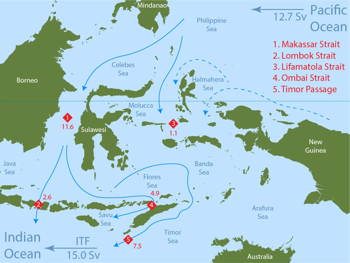
The Throughflow exists because of a deceptively simple fact: the sea surface in the western Pacific is slightly higher than in the adjacent Indian Ocean. The difference amounts to just centimeters, but across thousands of kilometers of ocean, that gentle slope creates an enormous pressure gradient. Warm water from the Pacific's upper layers flows "downhill" through Makassar Strait, the deep north-south channel between Borneo and Sulawesi, and enters the combined Java Sea and Banda Sea system. From there, the water finds its way out through three main exits: about 15 percent slips through the narrow Lombok Strait, which is just 35 kilometers wide and 300 meters deep, while the remaining 85 percent exits through the broader Timor Passage and the narrow Ombai Strait. The flow is not passive -- tides, Ekman pumping, and heat exchange all churn the water as it passes through, mixing it thoroughly before it reaches the Indian Ocean.
Governed by Monsoons
The Throughflow breathes with the seasons. During the southwest monsoon from June through August, southeasterly winds drive strong divergence in the surface waters around Indonesia, effectively pulling more water through the passages and boosting the flow to around 15 Sverdrups. When the northwest monsoon arrives from December to February, the pattern reverses: westerly winds push against the flow, slowing it down. The minimum comes in April, during the monsoon transition, when strong westerly winds in the eastern Indian Ocean generate equatorial Kelvin waves -- long, slow pressure waves that propagate through the Indonesian passages and temporarily raise sea levels on the Indian Ocean side, reducing the pressure gradient that drives the current. The result is a flow that drops to around 9 Sverdrups, roughly 60 percent of its peak. El Nino events add another layer of variability, generating Rossby waves in the Pacific that propagate into the Indonesian passages and can reduce the Throughflow by an additional 3 Sverdrups.
Warmth Across 10,000 Kilometers
What makes the Indonesian Throughflow globally important is not just its volume but its temperature. The western Pacific holds some of the warmest surface water on Earth, and that warmth flows through the Indonesian passages into the Indian Ocean, carrying roughly 1 petawatt of heat -- a figure comparable to the energy output of a million large power plants running continuously. Once in the Indian Ocean, this warm, relatively fresh water is swept westward by the South Equatorial Current toward the coast of East Africa. There, it joins the Agulhas Current and eventually rounds the southern tip of Africa into the Atlantic Ocean. The Throughflow thus serves as a critical link in the global thermohaline circulation, the vast oceanic conveyor belt that distributes heat around the planet. Block it -- as geological shifts have done in the deep past -- and climate models predict significant cooling in the Indian Ocean, altered monsoon patterns across Asia, and shifts in rainfall from Australia to the Sahel.
A Laboratory of Turbulence
The passages of the Indonesian Throughflow are among the most turbulent places in the world's oceans. The narrowness of Lombok Strait forces currents up to 0.67 meters per second westward, while the deeper Ombai Strait funnels water through a channel 1,250 meters deep and 35 kilometers across. Timor Passage, the widest exit at 160 kilometers, compensates with sheer volume despite gentler speeds. Between 2004 and 2006, the INSTANT program -- International Nusantara Stratification and Transport -- deployed eleven moorings across these passages, producing the first precise measurements of each channel's contribution to the total flow. The data confirmed what models had predicted: this narrow archipelagic region dissipates enormous amounts of kinetic energy, with turbulence levels in the upper layers a thousand times greater than in the open ocean. For oceanographers, the Indonesian Throughflow is both a bottleneck and a mixing bowl, transforming the character of the water before releasing it into the Indian Ocean.
Visible from Above
From the air, the Indonesian Throughflow is invisible in the way that all ocean currents are -- you cannot see it, but you can see its consequences. The waters east of Lombok Strait are noticeably warmer and clearer than those to the west, where cooler Indian Ocean water meets the outflow. Fishermen in the Lesser Sunda Islands have known for centuries that the straits behave differently with the seasons, that the currents shift and the fish move with them. What they understood intuitively, oceanography has since quantified: the Indonesian Throughflow transports Pacific warmth roughly 10,000 kilometers to the southwest Indian Ocean, connecting a strait that a strong swimmer could almost cross to weather patterns that shape life on three continents. It is one of the planet's great circulatory systems, hidden in plain sight between a chain of volcanic islands.
From the Air
The Indonesian Throughflow region is centered around 5.61°S, 115.28°E, in the waters between the Indonesian islands of Java, Borneo, Sulawesi, and the Lesser Sunda Islands. From cruising altitude, the key straits are visible: Makassar Strait between Borneo and Sulawesi, Lombok Strait between Bali and Lombok, and the broader Timor Passage to the south. Major nearby airports include Ngurah Rai International Airport (WADD) in Bali, Juanda International Airport (WARR) near Surabaya, and Lombok International Airport (WADL). Visibility is generally good at altitude, though tropical convective clouds are common, especially during the wet monsoon season from December through February.
Nearby Stories
- Forty Hours in the Masalembo Sea 47 km away
- The Ship That Lost Its Name 145 km away
- Where Three Worlds Meet: The Great Mosque of Sumenep 158 km away
- The U-Boat That Planted a Secret on Two Continents 158 km away
- The River That Connects Borneo to Madagascar 196 km away
- The Sultanate of Banjar 221 km away
- Forty-Five Men and Thirty-Six Depth Charges 228 km away
- Two Minutes of Distraction 328 km away